Login
Register
CYVR
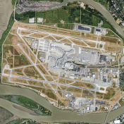
Vancouver International Airport
VFR Chart of CYVR
Sectional Charts at SkyVector.com
IFR Chart of CYVR
Enroute Charts at SkyVector.com
Location Information for CYVR
Coordinates: N49°11.68' / W123°10.95'View all Airports in British Columbia, Canada.
Elevation is 13 feet MSL.
Magnetic Variation from 2015 is 17° East
Time Zone is UTC-8(7).
Operations Data
|
|
Customs Information
AOE 888-226-7277
Airport Communications
| Remote Communications Outlet (RCO) | Pacific Radio 123.15 (FISE) |
|---|---|
| Automated Terminal Information Service (ATIS) | 124.6 restrictions are bcst on ATIS 1-877-517-2847 |
| Clearance Delivery (CLNC DEL) | 121.4 all dep acft ctc clnc del |
| Ground Control (GND) | 121.7 (South) 127.15 (North) 275.8 |
| Control Tower (TWR) | 118.7 (South) 119.55 (North) VFR 124.02 125.65 226.5 236.6 (E) (Emergency 604-775-9531) |
| Terminal (TML) | 125.2 |
| Arrival (ARR) | 128.6/128.17 (Outer) 133.1 (Inner) 134.225 (Inner) 352.7 |
| Departure (DEP) | 126.125 (North) 132.3 (South) 363.8 |
Nearby Navigation Aids
|
| ||||||||||||||||||||||||||||||||||||||||||||||||||||||||||||
Runway 08R/26L
| Dimensions: | 12188 x 200 feet. | |
|---|---|---|
| Surface: | ||
| Remarks | ASPH/CONC | |
| Runway 08R | Runway 26L | |
| Runway Heading: | 083° | 263° |
| Displaced Threshold: | 696 feet | 689 feet |
| Approach Lights | ALSF-2: Category II/III High Intensity Approach Lighting System. | ALSF-2: Category II/III High Intensity Approach Lighting System. |
| Glide Slope Indicator | PAPI for aircraft with eye-to-wheel height up to 45 feet. | PAPI for aircraft with eye-to-wheel height up to 45 feet. |
Runway 08L/26R
| Dimensions: | 9941 x 200 feet. | |
|---|---|---|
| Surface: | ||
| Remarks | CONC Rwy 08L first 2027' down 0.3% | |
| Runway 08L | Runway 26R | |
| Runway Heading: | 083° | 263° |
| Approach Lights | ALSF-2: Category II/III High Intensity Approach Lighting System. | ALSF-2: Category II/III High Intensity Approach Lighting System. |
| Glide Slope Indicator | PAPI for aircraft with eye-to-wheel height up to 45 feet. | PAPI for aircraft with eye-to-wheel height up to 45 feet. |
Runway 13/31
| Dimensions: | 7300 x 200 feet. | |
|---|---|---|
| Surface: | ||
| Remarks | ASPH/CONC RESA: 08R/26L 984'; 08L 984'; 26R 492'; 13/31 492' Apron I, II, III, IV, V, VI, VIII: PPR Airport Ops is required. PPR for all engine airstarts | |
| Runway 13 | Runway 31 | |
| Runway Heading: | 125° | 305° |
| Approach Lights | Omni-Directional Approach Lighting System | Omni-Directional Approach Lighting System |
| Glide Slope Indicator | PAPI for aircraft with eye-to-wheel height up to 45 feet. | PAPI for aircraft with eye-to-wheel height up to 45 feet. |
Helipad Information
Pad C: FATO 108' dia CONC/ASPH TLOF 33' x 33' CONC Safety Area 148' dia
Max heli overall length 73'
Taxiway Information
Use of reverse thrust is to be avoided or reduced when conditions permit. M1, M3, M5
(rapid exit): Design speed in wet conditions is 50 kt (93 km/h).
Acft exiting onto D1, turn north on E, do not stop in Rwy area (See HOT SPOT 4). D1,
Services Available
| Fuel Available | 100LL, JA (FSII avbl), JA-1 (FSII avbl), HPR |
|---|---|
| Servicing Available | Storage, Minor Repairs, Major Repairs |
| Aircraft Rescue and Fire-fighting | DESIGNATED CAT 10 |
| Supporting Fluids, Systems, and Oxygen | LHOX D & A-ice |
| Jet Aircraft Starting Units (JASU) | CE16, Air Start |
| Private Advisory | Air Elite by World Fuel 122.85 604-270-2222; Million Air 122.95 604-273-6688; Signature Flight Support 123.325 604-279-9922; Seair Seaplanes 122.85 1-800-447-3247 604-273-8900 at adj water A/D. |
| Military Contract Fuel | Sky Service 523-720-4882 |
Public Facilities
Main tml bldg | Location | Facilities | Remarks |
|---|---|---|
| In Terminal Building | Telephone, Food, Taxi, Medical Aid, Accomodations, Car Rental | ; South side tml bldg |
| In Terminal Building | Telephone, Food, Taxi, Car Rental | |
| On Aerodrome | Accomodations |
Flight Planning
| Flight Information Centre (FIC) | Kamloops 866-WXBRIEF (Toll free within Canada) or 866-541-4101 (Toll free within Canada & USA) |
|---|---|
| Area Control Centre (ACC) | IFR 604-586-4590/4591 or 800-668-1333; IFR tng flts PPR ctc 604-586-4592 (collect calls accepted) |
| Weather (WX) | METAR H24. TAF H24, issue times: 00, 03, 06, 09, 12, 15, 18, 21Z. WxCam |
| Direct User Access Terminal (DUAT) | Esso Avitat, Landmark (Shell Aerocentre) |
Aerodrome Operator
Vancouver International Airport Authority 604-207-7022
H24 Cert Ldg fees
Nearby Airports with Instrument Procedures
| ID | Name | Heading / Distance | ||
|---|---|---|---|---|
 |
CYCD | Nanaimo Airport | 235° | 28.4 |
 |
CYXX | Abbotsford Airport | 090° | 34.0 |
 |
CYYJ | Victoria International Airport | 179° | 34.3 |
 |
CYQQ | Comox Airport | 278° | 73.6 |
 |
CYBL | Campbell River Airport | 282° | 93.4 |
 |
CYAZ | Tofino/Long Beach Airport | 250° | 102.3 |
 |
CYDC | Princeton Airport | 063° | 106.1 |
 |
CYKA | Kamloops Airport | 031° | 139.4 |


