Login
Register
1J9
Fort Walton Beach Airport
Official FAA Data Effective 2025-01-23 0901Z
VFR Chart of 1J9
Sectional Charts at SkyVector.com
IFR Chart of 1J9
Enroute Charts at SkyVector.com
Location Information for 1J9
Coordinates: N30°24.38' / W86°49.75'Located 02 miles E of Navarre, Florida on 15 acres of land. View all Airports in Florida.
Surveyed Elevation is 22 feet MSL.
Operations Data
|
|
Airport Communications
| UNICOM: | 122.700 |
|---|---|
| CTAF: | 122.700 |
| ATIS at HRT (7.4 E): | 134.475 |
| ATIS at VPS (16.4 E): | 134.625 |
| ASOS at DTS (18.5 E): | 133.925 850-654-7128 |
Nearby Navigation Aids
|
| ||||||||||||||||||||||||||||||||||||||||||||||||||||||||||||
Runway 18/36
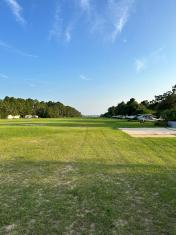
DEP RWY 18; ARR RWY 36. RWY SLOPES TO 2 FT AT S END. UNLGTD BRUSH, TREES, PRKG & BLDG 65-125 FT W OF CNTRLN FULL LEN. | ||
| Dimensions: | 2100 x 65 feet / 640 x 20 meters | |
|---|---|---|
| Surface: | Turf in Poor Condition BARE SPOTS SOFT & SANDY S OF MID POINT. | |
| Runway 18 | Runway 36 | |
| Coordinates: | N30°24.55' / W86°49.75' | N30°24.21' / W86°49.75' |
| Elevation: | 22.0 | 2.0 |
| Traffic Pattern: | Left | Left |
| Runway Heading: | 181° True | 1° True |
| Markings: | Non-Standard | Non-Standard |
| Obstacles: | 15 ft Building 87 ft from runway, 45 ft left of center | 3 ft Brush 57 ft from runway, 45 ft right of center |
Services Available
| Fuel: | NONE |
|---|---|
| Transient Storage: | NONE |
| Airframe Repair: | NONE |
| Engine Repair: | NONE |
| Bottled Oxygen: | NONE |
| Bulk Oxygen: | NONE |
Ownership Information
| Ownership: | Privately Owned | |
|---|---|---|
| Owner: | BOOMER AVIATION INC. | |
| P.O. BOX 1075 | ||
| FORT WALTON, FL 32549 | ||
| 850-244-1313 | ||
| Manager: | SANDY WILLIAMS | |
| P.O. BOX 1075, P.O. BOX | ||
| FT WALTON BEACH, FL 32549 | ||
| (850) 244-1313 | ||
Other Remarks
- BANNER TOWING.
- HEL MORE THAN 2500 LB NA.
- FOR CD CTC EGLIN APCH 850-882-9152 OR 850-882-9151.
- WHITE CONES.
- WHITE CONES.
Nearby Airports with Instrument Procedures
| ID | Name | Heading / Distance | ||
|---|---|---|---|---|
 |
KHRT | Hurlburt Field Airport | 079° | 7.4 |
 |
2R4 | Peter Prince Field Airport | 328° | 16.3 |
 |
KVPS | Eglin AFB/Destin-Ft Walton Beach Airport | 073° | 16.4 |
 |
KDTS | Destin Exec Airport | 091° | 18.6 |
 |
KPNS | Pensacola International Airport | 282° | 19.0 |
 |
KNDZ | Whiting Field NAS South Airport | 331° | 20.0 |
 |
KNSE | Whiting Field NAS North Airport | 331° | 21.4 |
 |
KEGI | Duke Field,(Eglin Af Aux Nr 3) Airport | 047° | 21.5 |
 |
KNPA | Pensacola NAS (Forrest Sherman Field) Airport | 262° | 25.6 |
 |
KCEW | Bob Sikes Airport | 035° | 27.4 |
 |
54J | Defuniak Springs Airport | 060° | 40.0 |
 |
12J | Brewton Municipal Airport | 342° | 40.5 |


