Login
Register


1O5
Montague-Yreka Rohrer Field Airport
Official FAA Data Effective 2026-02-19 0901Z
Chart Supplement

VFR Chart of 1O5
Sectional Charts at SkyVector.com
IFR Chart of 1O5
Enroute Charts at SkyVector.com
Location Information for 1O5
Coordinates: N41°43.80' / W122°32.67'Located 01 miles W of Montague, California on 90 acres of land. View all Airports in California.
Estimated Elevation is 2527 feet MSL.
Operations Data
|
|
Airport Communications
| CTAF: | 122.800 |
|---|---|
| UNICOM: | 122.800 |
| ASOS at SIY (4.3 NE): | 121.125 530-459-0267 |
| ASOS at MHS (26.8 S): | 120.775 530-918-8864 |
| ATIS at MFR (41.4 N): | 127.25 |
- COMMUNICATIONS PRVDD BY RANCHO MURIETA RADIO ON FREQ 122.4 (ANTELOPE MTN RCO)
Nearby Navigation Aids
|
| ||||||||||||||||||||||||||||||||||||||||||


Runway 15/33
| Dimensions: | 3360 x 50 feet / 1024 x 15 meters | |
|---|---|---|
| Surface: | Asphalt in Good Condition | |
| Weight Limits: | S-12 | |
| Edge Lighting: | Medium Intensity | |
| Runway 15 | Runway 33 | |
| Coordinates: | N41°44.06' / W122°32.79' | N41°43.54' / W122°32.55' |
| Elevation: | 2524.0 | 2517.0 |
| Traffic Pattern: | Right | Left |
| Displaced Threshold: | 150 Feet | |
| Markings: | Basic in good condition. | Basic in good condition. |
| Obstacles: | 15 ft Road 350 ft from runway | |
Runway 05/23
| Dimensions: | 2080 x 100 feet / 634 x 30 meters | |
|---|---|---|
| Surface: | Turf in Good Condition | |
| Runway 05 | Runway 23 | |
| Traffic Pattern: | Left | Right |
| Markings: | None | None |
Services Available
| Fuel: | 100LL (blue) |
|---|---|
| Transient Storage: | Tiedowns |
| Airframe Repair: | MINOR |
| Engine Repair: | MINOR |
| Bottled Oxygen: | NOT AVAILABLE |
| Bulk Oxygen: | NOT AVAILABLE |
| Other Services: | CARGO HANDLING SERVICES,GLIDER SERVICE,PILOT INSTRUCTION,AIRCRAFT RENTAL,GLIDER TOWING SERVICES |
Ownership Information
| Ownership: | Publicly owned | |
|---|---|---|
| Owner: | CITY OF MONTAGUE | |
| PO BOX 428 | ||
| MONTAGUE, CA 96064 | ||
| 530-459-3030 | ||
| Manager: | BOB STEELMAN | |
| 11423 AXINITE COURT | ||
| MONTAGUE, CA 96064 | ||
| (530) 459-3392 | ||
Other Remarks
- DEER ON & INVOF ARPT.
- BE ALERT TO MOUNTAIN NORTH AND HILLS EAST AND WEST OF AIRPORT.
- OCNL GLD AND BLN LAUNCHES.
- USE OF RY TRAFFIC PATTERNS STRONGLY RECOMMENDED. AVOID OVERFLIGHT OF TOWN EAST OF ARPT.
- APRT RESTRICTED TO ACFT WITH MAX CERT TKOF WEIGHT OF 12,500 LBS OR LESS; FOR MORE INFO CALL APT OPS (530) 459-5204.
- FOR CD CTC SEATTLE ARTCC AT 253-351-3694.
- RY 05/23 EDGES MARKED WITH WHITE TIRES.
- MIRL RY 15/33 PRESET LOW INTST; TO INCR INTST ACTVT - CTAF.
Nearby Airports with Instrument Procedures
| ID | Name | Heading / Distance | ||
|---|---|---|---|---|
 |
O46 | Weed Airport | 164° | 15.5 |
|
KMFR | Rogue Valley International/Medford Airport | 339° | 41.4 |
|
KLMT | Crater Lake/Klamath Regional Airport | 054° | 44.4 |
|
3S8 | Grants Pass Airport | 321° | 60.1 |
|
O85 | Benton Field Airport | 174° | 69.6 |
|
KRDD | Redding Regional Airport | 171° | 74.1 |
|
KCEC | Jack Mc Namara Field Airport | 272° | 76.0 |
|
KBOK | Brookings Airport | 285° | 80.9 |
|
KACV | California Redwood Coast-Humboldt County Airport | 237° | 83.8 |
|
KEKA | Murray Field Airport | 232° | 90.1 |
|
KAAT | Alturas Municipal Airport | 098° | 90.3 |
|
4S1 | Gold Beach Municipal Airport | 296° | 93.5 |
Airport Images
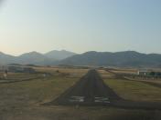
By: jgills240


