Login
Register
1U7
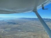
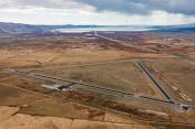
Bear Lake County Airport
Official FAA Data Effective 2025-12-25 0901Z
VFR Chart of 1U7
Sectional Charts at SkyVector.com
IFR Chart of 1U7
Enroute Charts at SkyVector.com
Location Information for 1U7
Coordinates: N42°14.99' / W111°20.50'Located 03 miles E of Paris, Idaho on 1180 acres of land. View all Airports in Idaho.
Surveyed Elevation is 5932 feet MSL.
Operations Data
|
|
Airport Communications
| AWOS-3: | 118.525 Tel. 208 847 0613 |
|---|---|
| UNICOM: | 122.800 |
| CTAF: | 122.800 |
| AWOS-3P at AFO (33.0 NE): | 119.025 307-885-2654 |
| ASOS at LGU (35.9 SW): | 135.275 435-752-6941 |
| AWOS-3PT at EMM (43.3 SE): | 119.675 307-877-9838 |
- APCH/DEP CTL SVC PRVDD BY SALT LAKE ARTCC (ZLC) ON 128.35/239.25 BLACKFOOT RCAG.
Nearby Navigation Aids
|
| ||||||||||||||||||||||||||||||||||||
Runway 10/28
| Dimensions: | 5728 x 75 feet / 1746 x 23 meters | |
|---|---|---|
| Surface: | Asphalt in Excellent Condition | |
| Weight Limits: | S-14, D-28, ST-60 | |
| Edge Lighting: | Medium Intensity | |
| Runway 10 | Runway 28 | |
| Coordinates: | N42°15.28' / W111°20.86' | N42°14.88' / W111°19.72' |
| Elevation: | 5930.2 | 5932.9 |
| Traffic Pattern: | Left | Left |
| Runway Heading: | 115° True | 295° True |
| Markings: | Non-Precision Instrument in good condition. | Non-Precision Instrument in good condition. |
| Glide Slope Indicator | P2L (3.50° Glide Path Angle) PAPI UNSUBL BYD 8 NM FM THR DUE TO MOUNTAINOUS TRRN. | P2L (3.50° Glide Path Angle) |
| REIL: | Yes | Yes |
| Obstacles: | 60 ft Power Line 2500 ft from runway | 12 ft Road 500 ft from runway |
Runway 16/34
NO SNOW REMOVAL RWY 16/34. | ||
| Dimensions: | 4590 x 60 feet / 1399 x 18 meters | |
|---|---|---|
| Surface: | Asphalt in Good Condition | |
| Weight Limits: | S-50, D-64, ST-102 | |
| Runway 16 | Runway 34 | |
| Coordinates: | N42°15.24' / W111°20.80' | N42°14.49' / W111°20.71' |
| Elevation: | 5930.0 | 5929.6 |
| Traffic Pattern: | Left | Left |
| Runway Heading: | 175° True | 355° True |
| Markings: | Basic in good condition. | Basic in good condition. |
Services Available
| Fuel: | 100LL (blue) |
|---|---|
| Transient Storage: | Tiedowns |
| Airframe Repair: | NONE |
| Engine Repair: | NONE |
| Bottled Oxygen: | NONE |
| Bulk Oxygen: | NONE |
Ownership Information
| Ownership: | Publicly owned | |
|---|---|---|
| Owner: | BEAR LAKE COUNTY | |
| PO BOX 190 | ||
| PARIS, ID 83261 | ||
| 208-945-2212 | ||
| Manager: | TREVOR KEETCH | |
| P O BOX 163 | ||
| MONTPELIER, ID 83254 | ||
| 208-223-0416 | 208-223-0416 CELL, AVBL 24 HRS. | |
Other Remarks
- BIRDS ON & INVOF OF ARPT.
- REFLECTORS ON ALL TWYS AND APRONS.
- PARTIAL TWY 25 FT WIDE.
- NO SNOW REMOVAL RWY 16/34.
- FOR CD CTC SALT LAKE ARTCC AT 801-320-2568.
- COLD TEMPERATURE AIRPORT. ALTITUDE CORRECTION REQUIRED AT OR BELOW -22C.
- RUNWAY 16/34 HAS RUNWAY SIDE STRIPE MARKING
- 0LL 100 LL FUEL AVBL 24 HRS WITH CREDIT CARD SELF SVC.
- ACTVT REIL RWY 10 & 28; MIRL RWY 10/28 - CTAF.
Weather Minimums
Instrument Approach Procedure (IAP) Charts
Departure Procedure Obstacles (DPO) Charts
Nearby Airports with Instrument Procedures
| ID | Name | Heading / Distance | ||
|---|---|---|---|---|
 |
KAFO | Afton Lincoln County/General Boyd L Eddins Field Airport | 032° | 32.7 |
 |
KLGU | Logan-Cache Airport | 219° | 35.7 |
 |
KEMM | Kemmerer Municipal Airport | 125° | 43.4 |
 |
KBMC | Brigham City Regional Airport | 217° | 52.7 |
 |
KBPI | Miley Memorial Field Airport | 069° | 58.3 |
 |
KEVW | Evanston-Uinta County Burns Field Airport | 166° | 60.1 |
 |
KFBR | Fort Bridger Airport | 140° | 66.3 |
 |
KPIH | Pocatello Regional Airport | 305° | 68.3 |
 |
KOGD | Ogden-Hinckley Airport | 205° | 70.1 |
 |
U02 | Mccarley Field Airport | 322° | 72.8 |
 |
KHIF | Hill AFB Airport | 203° | 73.2 |
 |
KPNA | Ralph Wenz Field Airport | 063° | 75.4 |


