Login
Register


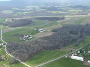
2MD8
Greater Gortner Airport
Official FAA Data Effective 2026-01-22 0901Z
VFR Chart of 2MD8
Sectional Charts at SkyVector.com
IFR Chart of 2MD8
Enroute Charts at SkyVector.com
Location Information for 2MD8
Coordinates: N39°20.01' / W79°26.49'Located 05 miles SW of Oakland, Maryland on 15 acres of land. View all Airports in Maryland.
Estimated Elevation is 2500 feet MSL.
Operations Data
|
|
Airport Communications
| AWOS-3 at 2G4 (15.7 N): | 120.125 301-746-8443 |
|---|---|
| AWOS-3 at W99 (24.5 SE): | 124.475 304-257-2477 |
| ASOS at MGW (29.2 NW): | 120.675 304-371-2021 |
Nearby Navigation Aids
|
| ||||||||||||||||||||||||||||||||||||||||||||||||||||||||||||


Runway 04/22
| Dimensions: | 2034 x 50 feet / 620 x 15 meters | |
|---|---|---|
| Surface: | Turf | |
| Runway 04 | Runway 22 | |
Ownership Information
| Ownership: | Privately Owned | |
|---|---|---|
| Owner: | PAUL & NAOMI YODER | |
| 2244 BLUE RIBBON RD | ||
| OAKLAND, MD 21550 | ||
| (301) 334-9663 | ||
| Manager: | THOMAS SWARTZENTRUBER | |
| 100 GENERAL KELLY ROAD | ||
| OAKLAND, MD 21550 | ||
| (301) 616-4766 | ||
Other Remarks
- FOR CD CTC WASHINGTON ARTCC AT 703-771-3587.
Nearby Airports with Instrument Procedures
| ID | Name | Heading / Distance | ||
|---|---|---|---|---|
 |
2G4 | Garrett County Airport | 018° | 15.6 |
|
W99 | Grant County Airport | 145° | 24.5 |
|
KMGW | Morgantown Municipal/Walter L Bill Hart Field Airport | 310° | 28.9 |
|
79D | Philippi/Barbour County Regional Airport | 251° | 30.6 |
|
KEKN | Elkins/Randolph County (Jennings Randolph Field) Airport | 216° | 32.9 |
|
4G7 | Fairmont Municipal-Frankman Field Airport | 281° | 34.5 |
|
KCBE | Greater Cumberland Regional Airport | 061° | 35.8 |
|
KCKB | North Central West Virginia Airport | 266° | 36.7 |
|
KVVS | Joseph A Hardy Connellsville Airport | 345° | 38.8 |
|
W22 | Upshur County Regional Airport | 243° | 43.7 |
|
KWAY | Greene County Airport | 317° | 46.7 |
|
2G9 | Somerset County Airport | 024° | 46.7 |
Airport Images

By: Big Orange Bird
By: Big Orange Bird


