Login
Register


39P
Strom Field Airport
Official FAA Data Effective 2025-12-25 0901Z
Chart Supplement

VFR Chart of 39P
Sectional Charts at SkyVector.com
IFR Chart of 39P
Enroute Charts at SkyVector.com
Location Information for 39P
Coordinates: N46°33.02' / W122°16.00'Located 00 miles SE of Morton, Washington on 13 acres of land. View all Airports in Washington.
Estimated Elevation is 941 feet MSL.
Operations Data
|
|
Airport Communications
| CTAF: | 122.900 |
|---|---|
| AWOS-3 at CLS (30.5 W): | 118.025 360-740-5164 |
| AWOS-3 at PLU (33.0 N): | 128.575 253-848-2748 |
| ATIS at GRF (34.3 N): | 124.65 |
Nearby Navigation Aids
|
| ||||||||||||||||||||||||||||||||||||||||||


Runway 07/25
| Dimensions: | 1810 x 40 feet / 552 x 12 meters | |
|---|---|---|
| Surface: | Asphalt in Failed Condition WDSPR RAVELLING AND ALLIGATOR CRACKING. | |
| Edge Lighting: | Medium Intensity | |
| Runway 07 | Runway 25 | |
| Coordinates: | N46°33.02' / W122°16.21' | N46°33.02' / W122°15.78' |
| Traffic Pattern: | Left | Left |
| Runway Heading: | 90° True | 270° True |
| Displaced Threshold: | 200 Feet | |
| Markings: | Basic in poor condition. | Basic in poor condition. |
| Obstacles: | 50 ft Power Line 324 ft from runway APCH SLOPE 8:1 TO DSPLCD THLD. +3 FT FENCE AT 35 FT FM THR AND 32 FT R; GUARD RAIL AND ROAD 98 FT FM THR; 15 FT SIGN, 18 FT R, 65 FT FM THR; TREE, 51 FT HIGH, 2 FT R, 120 FT FM THR, 10 FT SIGN 84 FT L, 30 FT FM THR; FENCE 102 FT L, 15 FT FM THR; ROAD 120 FT L. |
RWY 25 +2 FT ROAD AND GUARD RAIL AT 15 FT FM THR; TREE, 15 FT HIGH, 49 FT R, 74 FT FM THR; POLE, 4 FT HIGH, 79 FT R, 8 FT FM THR. |
Services Available
| Fuel: | NONE |
|---|---|
| Transient Storage: | Tiedowns PILOTS BRING OWN TIEDOWNS. |
| Airframe Repair: | NONE |
| Engine Repair: | NONE |
| Bottled Oxygen: | NOT AVAILABLE |
| Bulk Oxygen: | NOT AVAILABLE |
Ownership Information
| Ownership: | Publicly owned | |
|---|---|---|
| Owner: | CITY OF MORTON | |
| PO BOX 1089 | ||
| MORTON, WA 98356 | ||
| 360-496-6881 | ||
| Manager: | ANDERS POLLMAN | PUB. WKS. SUP. |
| PO BOX 1089, PO BOX 1089 | ||
| MORTON, WA 98356 | ||
| (360) 496-5210 | ||
Other Remarks
- TREES NEAR RWY.
- TREES, STREAM, AND BRUSH IN PRIM SFC.
- DEER AND ELK ON & INVOF RWY.
- DITCH PARL RWY ON EASTSIDE.
- FOR CD CTC SEATTLE ARTCC AT 253-351-3694.
- SLP ON N SIDE ON RWY MID-FIELD BGNG AT SHOULDER.
- MARKINGS FADED.
- MARKINGS FADED.
- ACTVT MIRL RY 07/25 - CTAF.
- ACTVT ROTG BCN - CTAF.
Nearby Airports with Instrument Procedures
| ID | Name | Heading / Distance | ||
|---|---|---|---|---|
 |
KTDO | Ed Carlson Memorial Field/South Lewis County Airport | 259° | 22.8 |
|
KCLS | Chehalis-Centralia Airport | 284° | 30.6 |
|
KPLU | Pierce County/Thun Field Airport | 358° | 33.2 |
|
KGRF | Gray AAF (Joint Base Lewis-Mcchord) Airport | 337° | 34.3 |
|
KOLM | Olympia Regional Airport | 314° | 36.3 |
|
KTCM | Mcchord Field (Joint Base Lewis-Mcchord) Airport | 346° | 36.3 |
|
KKLS | Southwest Washington Regional Airport | 225° | 36.9 |
|
KTIW | Tacoma Narrows Airport | 343° | 44.9 |
|
S50 | Auburn Municipal Airport | 002° | 46.7 |
|
KSPB | Scappoose Airport | 208° | 53.0 |
|
KSEA | Seattle-Tacoma International Airport | 358° | 54.0 |
|
KSHN | Sanderson Field Airport | 318° | 54.7 |
Airport Images
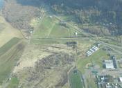
By: baronet68


Comments
Strom 39P Windsock, Beacon & Terrain.
Windsock & Rotating Beacon on roof of west hangar. High terrain southwest of airport boundary.
22blades