Login
Register


4T2
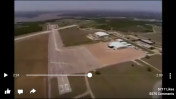
Kenneth Copeland Airport
Official FAA Data Effective 2026-02-19 0901Z
Chart Supplement

VFR Chart of 4T2
Sectional Charts at SkyVector.com
IFR Chart of 4T2
Enroute Charts at SkyVector.com
Location Information for 4T2
Coordinates: N32°58.66' / W97°29.54'Located 18 miles NW of Fort Worth, Texas. View all Airports in Texas.
Surveyed Elevation is 693 feet MSL.
Operations Data
|
|
Airport Communications
| LONE STAR APPROACH: | 125.8 257.95 |
|---|---|
| LONE STAR DEPARTURE: | 125.8 257.95 |
| CTAF: | 123.075 |
| UNICOM: | 123.075 |
| ASOS at AFW (8.7 E): | 817-491-6188 |
| ATIS at AFW (8.7 E): | 126.925 |
| ASOS at FTW (11.2 SE): | 817-740-3346 |
Nearby Navigation Aids
|
| ||||||||||||||||||||||||||||||||||||||||||||||||||||||||||||


Runway 17/35
| Dimensions: | 5943 x 127 feet / 1811 x 39 meters | |
|---|---|---|
| Surface: | Asphalt-Concrete in Poor Condition OUTER 50 FT OF EACH SIDE OF RY IS ASPH, CENTER 40 FT IS CONC ON RY 17 END; ASPH ON RY 35 END. ASPH CRACKING W. LOOSE AGGREGATE. | |
| Edge Lighting: | Low Intensity | |
| Runway 17 | Runway 35 | |
| Coordinates: | N32°59.15' / W97°29.58' | N32°58.17' / W97°29.49' |
| Elevation: | 687.5 | 660.1 |
| Runway Heading: | 175° True | 355° True |
| Markings: | Non-Precision Instrument in fair condition. | Non-Precision Instrument in fair condition. |
| Obstacles: | 15 ft Road 201 ft from runway, 122 ft right of center CONTROLLING OBSTN IS A PVT RD WITH OCCASIONAL 13-15 FT EQUIPMENT. 15 FT ROAD 0-199 FT FM RWY END, ACRS APCH. |
55 ft Trees 1180 ft from runway, 240 ft left of center 10 FT RD 0-75 FT DSTC 145 L/R. |
Ownership Information
| Ownership: | Privately Owned | |
|---|---|---|
| Owner: | KEN COPELAND MINISTRIES | |
| 14355 MORRIS DIDO RD. | ||
| NEWARK, TX 76071 | ||
| 817-252-3500 | ||
| Manager: | JONATHAN OSORIO | |
| 14355 MORRIS DIDO RD | ||
| NEWARK, TX 76071 | ||
| 817-252-3510 | ||
Other Remarks
- TSNT ACFT 3 HRS PPR.
- TWY A POOR COND, OUTER 18 FT OF EACH SIDE IS ASPH, CNTR 39 FT IS CONC.
- EXTSV HEL ACT IN AREA.
- FOR CD CTC LONE STAR APCH AT 972-615-2799.
- 260 FT AGL TWR 0.7 NM NW RWY 17 END.
- ACTVT LIRL RWY 17/35; TWY - CTAF.
Weather Minimums

Instrument Approach Procedure (IAP) Charts


Nearby Airports with Instrument Procedures
| ID | Name | Heading / Distance | ||
|---|---|---|---|---|
 |
KAFW | Perot Field/Fort Worth Alliance Airport | 084° | 8.8 |
|
KFTW | Fort Worth Meacham International Airport | 145° | 11.5 |
|
KNFW | Fort Worth NAS Jrb (Carswell Field) Airport | 168° | 12.7 |
|
KWEA | Parker County Airport | 214° | 16.9 |
|
KLUD | Decatur Municipal Airport | 345° | 17.2 |
|
KDTO | Denton Enterprise Airport | 047° | 20.0 |
|
KXBP | Bridgeport Municipal Airport | 304° | 20.6 |
|
KDFW | Dallas-Fort Worth International Airport | 101° | 23.5 |
|
50F | Bourland Field Airport | 191° | 24.2 |
|
KFWS | Fort Worth Spinks Airport | 159° | 26.4 |
|
KGKY | Arlington Municipal Airport | 132° | 27.5 |
|
KGPM | Grand Prairie Municipal Airport | 126° | 28.0 |
Airport Images

By: slowpoke96z28
By: slowpoke96z28


