Login
Register
67L
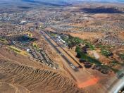
Mesquite Airport
Official FAA Data Effective 2025-12-25 0901Z
VFR Chart of 67L
Sectional Charts at SkyVector.com
IFR Chart of 67L
Enroute Charts at SkyVector.com
Location Information for 67L
Coordinates: N36°49.99' / W114°3.35'Located 02 miles N of Mesquite, Nevada on 155 acres of land. View all Airports in Nevada.
Surveyed Elevation is 1978 feet MSL.
Operations Data
|
|
Airport Communications
| AWOS-2: | 118.525 Tel. 702-345-7634 |
|---|---|
| UNICOM: | 122.800 |
| CTAF: | 122.800 |
| AWOS-3PT at SGU (29.4 NE): | 135.075 435-634-0940 |
| AWOS-3PT at AZC (50.6 E): | 118.375 928-875-8045 |
| AWOS-3PT at 1G4 (52.0 S): | 119.425 928-237-1354 |
- APCH/DEP CTL SVC PRVDD BY LOS ANGELES ARTCC (ZLA) ON FREQS 124.2/343.6 (CEDAR CITY RCAG).
Nearby Navigation Aids
|
| ||||||||||||||||||||||||||||||||||||
Runway 02/20
-20 FT DROPOFF 90 FT R & PARL TO CNTRLN. ARR RWY 02 & DEP RWY 20 RCMDD IN NO WIND COND DUE TO SLOPE. | ||
| Dimensions: | 5121 x 75 feet / 1561 x 23 meters | |
|---|---|---|
| Surface: | Asphalt in Excellent Condition | |
| Weight Limits: | S-30
PCR VALUE: 170/F/C/X/T
| |
| Edge Lighting: | Medium Intensity | |
| Runway 02 | Runway 20 | |
| Coordinates: | N36°49.62' / W114°3.61' | N36°50.36' / W114°3.10' |
| Elevation: | 1876.3 | 1978.1 |
| Traffic Pattern: | Left | Left |
| Runway Heading: | 29° True | 209° True |
| Markings: | Non-Precision Instrument in good condition. | Non-Precision Instrument in good condition. |
| Glide Slope Indicator | P2L (3.00° Glide Path Angle) | P2L (3.00° Glide Path Angle) |
| REIL: | Yes | Yes |
| Obstacles: | +3 FT FENCE 88 FT L & PARL TO CNTRLN. |
140 ft Hill 2800 ft from runway |
Helipad H1
| Dimensions: | 20 x 20 feet / 6 x 6 meters | |
|---|---|---|
| Surface: | Concrete in Good Condition | |
| Edge Lighting: | Perimeter | |
| Coordinates: | N36°49.90' / W114°3.50' | N0°0.00' / E0°0.00' |
| Elevation: | 1910.0 | |
| Markings: | Basic in fair condition. | |
Services Available
| Fuel: | 100LL (blue), Jet-A |
|---|---|
| Transient Storage: | Tiedowns |
| Airframe Repair: | NONE |
| Engine Repair: | NONE |
| Bottled Oxygen: | NONE |
| Bulk Oxygen: | NONE |
| Other Services: | AIR AMBULANCE SERVICES,CARGO HANDLING SERVICES,GLIDER SERVICE,PARACHUTE JUMP ACTIVITY |
Ownership Information
| Ownership: | Publicly owned | |
|---|---|---|
| Owner: | CITY OF MESQUITE | |
| 10 E MESQUITE BLVD | ||
| MESQUITE, NV 89027 | ||
| 702-346-5295 | ||
| Manager: | TRAVIS ANDERSON | |
| 10 E MESQUITE BLVD | ||
| MESQUITE, NV 89027 | ||
| 702-346-5237 | ||
Other Remarks
- NOISE ABATEMENT PROC; AVOID OVR FLT DOWNTOWN MESQUITE 2 NM SW.
- PUB ACT WI 1000 FT OF RWY.
- FOR CD CTC LOS ANGELES ARTCC AT 661-575-2079.
- OTR CTC FBO - 702-246-2841/262-707-5980.
- 0LL 100LL AVBL SELF SVC WITH CREDIT CARD.
- ACTVT MIRL RWY 02/20 - CTAF.
Weather Minimums
Instrument Approach Procedure (IAP) Charts
Nearby Airports with Instrument Procedures
| ID | Name | Heading / Distance | ||
|---|---|---|---|---|
 |
KSGU | St George Regional Airport | 064° | 28.9 |
 |
KAZC | Colorado City Municipal Airport | 081° | 50.7 |
 |
KLSV | Nellis AFB Airport | 233° | 59.3 |
 |
KBVU | Boulder City Municipal Airport | 216° | 65.9 |
 |
KVGT | North Las Vegas Airport | 236° | 66.5 |
 |
KCDC | Cedar City Regional Airport | 041° | 69.3 |
 |
KLAS | Harry Reid International Airport | 229° | 69.7 |
 |
KHND | Henderson Exec Airport | 225° | 73.4 |
 |
KKNB | Kanab Municipal Airport | 081° | 74.1 |
 |
KIGM | Kingman Airport | 176° | 94.5 |
 |
U55 | Panguitch Municipal Airport | 052° | 100.1 |
 |
KIFP | Laughlin/Bullhead International Airport | 193° | 103.5 |


Comments
Good Stop Over or Stay and Play at the Casino
Good runway and ramp. Runway is sloped. Recommend landing 01 and departing 19 in light winds. Nice pilots lounge with bathrooms and snacks. Friendly airport manager. A bit quieter than St. George, UT. I believe there is a courtesy car. Close to Mesquite.