Login
Register


BIL
Billings Logan International Airport
Official FAA Data Effective 2024-04-18 0901Z
Chart Supplement

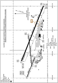
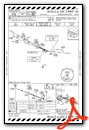
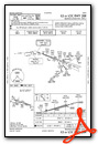
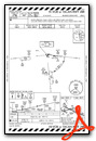
KBIL Airport Diagram
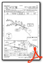
VFR Chart of KBIL
Sectional Charts at SkyVector.com
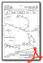
IFR Chart of KBIL
Enroute Charts at SkyVector.com
Location Information for KBIL
Coordinates: N45°48.47' / W108°32.61'Located 02 miles NW of Billings, Montana on 2500 acres of land. View all Airports in Montana.
Surveyed Elevation is 3662 feet MSL.
SINGLE ENGINE ACFT 4500 (838), MULTI ENGINE/TURBOJET ACFT 5000 (1338).
Operations Data
|
|
Airport Communications
| ATIS: | 126.3 |
|---|---|
| ASOS: | 126.3 Tel. 406-255-2790 |
| BILLINGS TOWER: | 127.2 257.8 |
| BILLINGS GROUND: | 121.9 |
| BILLINGS APPROACH: | 119.2 ;EAST 120.5 ;WEST 284.6 |
| BILLINGS DEPARTURE: | 119.2 ;EAST 120.5 ;WEST 284.6 |
| IC: | 120.5 ;WEST |
| CLEARANCE DELIVERY: | 121.9 |
| UNICOM: | 122.950 |
| PRE TAXI CLNC: | 121.9 |
| CLASS C: | 119.2 ;EAST 120.5 ;WEST 284.6 |
| EMERG: | 121.5 243.0 |
| AWOS-2 at 6S8 (10.9 SW): | 135.05 406-628-9867 |
| AWOS-3 at 00U (37.2 E): | 118.325 406-665-4241 |
| AWOS-3 at U68 (54.0 S): | 119.925 307-548-2560 |
Nearby Navigation Aids
|
| ||||||||||||||||||||||||||||||


Runway 10L/28R
| Dimensions: | 10518 x 150 feet / 3206 x 46 meters | |
|---|---|---|
| Surface: | Asphalt / Grooved in Good Condition | |
| Weight Limits: | 55 /F/B/X/T, S-120, D-214, ST-365 | |
| Edge Lighting: | High Intensity | |
| Runway 10L | Runway 28R | |
| Coordinates: | N45°48.76' / W108°33.29' | N45°48.12' / W108°30.99' |
| Elevation: | 3584.4 | 3488.2 |
| Runway Heading: | 111° True | 291° True |
| Declared Distances: | TORA:10518 TODA:10518 ASDA:10518 LDA:10518 | TORA:10518 TODA:10518 ASDA:10518 LDA:10518 |
| Markings: | Precision Instrument in good condition. | Precision Instrument in good condition. |
| Glide Slope Indicator | P4L (3.00° Glide Path Angle) | P4R (3.00° Glide Path Angle) |
| RVR Equipment | Touchdown | Rollout |
| Approach Lights: | MALSR 1,400 Foot Medium-intensity Approach Lighting System with runway alignment indicator lights. | |
| REIL: | Yes | |
| Obstacles: | 12 ft Ground 200 ft from runway, 400 ft left of center +12' GND 0-200' FM RY END 400' L. |
|
Runway 07/25
| Dimensions: | 5501 x 75 feet / 1677 x 23 meters | |
|---|---|---|
| Surface: | Asphalt / Grooved in Good Condition | |
| Weight Limits: | 7 /F/B/X/U, S-12 | |
| Edge Lighting: | Medium Intensity | |
| Runway 07 | Runway 25 | |
| Coordinates: | N45°48.46' / W108°33.50' | N45°48.56' / W108°32.22' |
| Elevation: | 3636.3 | 3533.8 |
| Runway Heading: | 84° True | 264° True |
| Declared Distances: | TORA:5501 TODA:5501 ASDA:5501 LDA:5501 | TORA:5501 TODA:5501 ASDA:5501 LDA:5501 |
| Markings: | Non-Precision Instrument in good condition. | Non-Precision Instrument in good condition. |
| Glide Slope Indicator | P4L (3.00° Glide Path Angle) | P4R (3.00° Glide Path Angle) |
| REIL: | Yes | |
| Obstacles: | 20 ft Ground 600 ft from runway | |
Runway 10R/28L
| Dimensions: | 3800 x 75 feet / 1158 x 23 meters | |
|---|---|---|
| Surface: | Asphalt in Good Condition | |
| Weight Limits: | 4 /F/B/X/U, S-12 | |
| Edge Lighting: | Medium Intensity | |
| Runway 10R | Runway 28L | |
| Coordinates: | N45°48.61' / W108°33.98' | N45°48.38' / W108°33.15' |
| Elevation: | 3662.3 | 3614.0 |
| Runway Heading: | 111° True | 291° True |
| Declared Distances: | TORA:3801 TODA:3801 ASDA:3801 LDA:3801 | TORA:3801 TODA:3801 ASDA:3801 LDA:3801 |
| Markings: | Basic in fair condition. | Basic in fair condition. |
| Obstacles: | 52 ft Ground 2251 ft from runway | |
Services Available
| Fuel: | 100LL (blue), Jet-A |
|---|---|
| Transient Storage: | Hangars,Tiedowns |
| Airframe Repair: | MAJOR |
| Engine Repair: | MAJOR |
| Bottled Oxygen: | HIGH/LOW |
| Bulk Oxygen: | HIGH/LOW |
| Other Services: | AIR FREIGHT SERVICES,AIR AMBULANCE SERVICES,AVIONICS,CARGO HANDLING SERVICES,CHARTER SERVICE,PILOT INSTRUCTION,AIRCRAFT RENTAL,AIRCRAFT SALES |
Ownership Information
| Ownership: | Publicly owned | |
|---|---|---|
| Owner: | CITY OF BILLINGS | |
| CITY HALL | ||
| BILLINGS, MT 59101 | ||
| 406-657-8495 | ||
| Manager: | JEFF ROACH, MANAGER | |
| 1901 TERMINAL CIRCLE DR., ROOM 216 | ||
| BILLINGS, MT 59105 | ||
| (406) 657-8484 | 406-657-8495 | |
Operational Statistics
| Single Engine Aircraft Based on Field: | 106 | Statistics collected for 12 month period ending 2023-12-31 | |
|---|---|---|---|
| Multi-Engine Aircraft Based on Field: | 62 | Annual Commercial Operations: | 12182 |
| Jet Aircraft Based on Field: | 22 | Annual Commuter Operations: | none |
| Helicopters Based on Field: | 7 | Annual Air Taxi Operations: | 29794 |
| Military Aircraft Based on Field: | none | Annual Military Operations: | 1523 |
| Gliders Based on Field: | none | Annual GA Local Operations: | 24906 |
| Ultralights Based on Field: | none | Annual GA Itinerant Operations: | 31343 |
Other Remarks
- TWY D 35 FT WIDE CLSD TO ACFT OVER 12,500 LBS.
- NO CUSTOMS, REMOTE ACFT PARKING, LTD GROUND HANDLING SVCS
- 180 DEG TURNS RY 10L/28R BY ACFT OVER 25000 LBS PROHIBITED.
- MIGRATORY WATERFOWL INVOF ARPT.
- RYS 07/25 AND 10R/28L CLSD TO ACFT OVER 12,500 LBS.
- ATC-CTL. FOR MIRL RYS 10R/28L & 07/25; HIRL RY 10L/28R; MALSR RY 10L & REIL RYS 25 & 28R - CTC ATCT.
- SINGLE ENGINE ACFT 4500 (838), MULTI ENGINE/TURBOJET ACFT 5000 (1338).
Weather Minimums
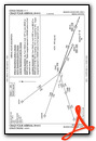
Standard Terminal Arrival (STAR) Charts
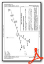
Instrument Approach Procedure (IAP) Charts
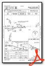
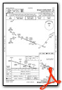
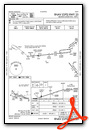
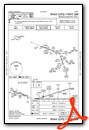
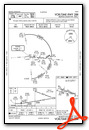
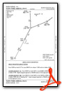
Departure Procedure (DP) Charts

Nearby Airports with Instrument Procedures
| ID | Name | Heading / Distance | ||
|---|---|---|---|---|
 |
6S8 | Laurel Municipal Airport | 236° | 11.0 |
|
00U | Big Horn County Airport | 095° | 37.3 |
|
KRPX | Roundup Airport | 000° | 40.0 |
|
U68 | North Big Horn County Airport | 175° | 53.9 |
|
KPOY | Powell Municipal Airport | 190° | 57.4 |
|
6S0 | Big Timber At Howard Field Airport | 270° | 60.2 |
|
KHWQ | Wheatland County At Harlowton Airport | 305° | 66.8 |
|
M46 | Colstrip Airport | 087° | 77.0 |
|
KGEY | South Big Horn County Airport | 165° | 79.8 |
|
KCOD | Yellowstone Regional Airport | 194° | 79.9 |
|
KLVM | Mission Field Airport | 266° | 80.3 |
|
KLWT | Lewistown Municipal Airport | 333° | 83.8 |
Fuel Providers

Airport Images
Do you have a recent image of this airport? Upload it here!


