Login
Register


BNG
Banning Municipal Airport
Official FAA Data Effective 2025-11-27 0901Z
Chart Supplement

VFR Chart of KBNG
Sectional Charts at SkyVector.com
IFR Chart of KBNG
Enroute Charts at SkyVector.com
Location Information for KBNG
Coordinates: N33°55.35' / W116°51.06'Located 01 miles SE of Banning, California on 295 acres of land. View all Airports in California.
Surveyed Elevation is 2222 feet MSL.
Operations Data
|
|
Airport Communications
| AWOS-3: | 134.625 Tel. 951-922-4674 |
|---|---|
| CTAF: | 122.800 |
| UNICOM: | 122.800 |
| AWOS-3PT at HMT (14.5 SW): | 118.375 951-925-6886 |
| ATIS at PSP (18.0 E): | 124.65 |
| ASOS at PSP (18.3 E): | 760-322-7597 |
Nearby Navigation Aids
|
| ||||||||||||||||||||||||||||||||||||||||||


Runway 08/26
| Dimensions: | 4955 x 100 feet / 1510 x 30 meters | |
|---|---|---|
| Surface: | Asphalt in Fair Condition | |
| Weight Limits: | S-12 | |
| Edge Lighting: | Medium Intensity | |
| Runway 08 | Runway 26 | |
| Coordinates: | N33°55.36' / W116°51.55' | N33°55.35' / W116°50.57' |
| Elevation: | 2222.4 | 2103.8 |
| Traffic Pattern: | Left | Right |
| Markings: | Basic in good condition. | Basic in good condition. |
| Glide Slope Indicator | P2L (3.50° Glide Path Angle) | |
Services Available
| Fuel: | 100LL (blue) |
|---|---|
| Transient Storage: | Tiedowns |
| Airframe Repair: | NONE |
| Engine Repair: | NONE |
| Bottled Oxygen: | NONE |
| Bulk Oxygen: | NONE |
Ownership Information
| Ownership: | Publicly owned | |
|---|---|---|
| Owner: | CITY OF BANNING | |
| P.O. BOX 998 | ||
| BANNING, CA 92220 | ||
| (951) 922-3105 | ||
| Manager: | CARL SZOYKA | |
| 176 EAST LINCOLN STREET, PO BOX 998 | ||
| BANNING, CA 92220-0998 | ||
| 951-922-3286 | ||
Other Remarks
- NO INTERSECTION TAKEOFFS TO THE WEST.
- RY 08/26 NO STRAIGHT-IN LANDINGS.
- RWY 26 AFTER TAKEOFF AVOID OVERFLYING HOUSES 4 MILES WEST.
- FOR CD CTC LOS ANGELES ARTCC AT 661-575-2079.
- 0LL FUEL AVBL WITH 24 HR SELF SVC CREDIT CARD. FUEL APN NOT LEVEL AND ACFT MAY NOT FILL COMPLETELY.
- ACTVT MIRL RWY 08/26 - CTAF.
Nearby Airports with Instrument Procedures
| ID | Name | Heading / Distance | ||
|---|---|---|---|---|
 |
KHMT | Hemet-Ryan Airport | 217° | 14.2 |
|
KREI | Redlands Municipal Airport | 303° | 17.7 |
|
KPSP | Palm Springs International Airport | 107° | 18.1 |
|
KRIV | March Arb Airport | 263° | 20.5 |
|
L35 | Big Bear City Airport | 359° | 20.4 |
|
KSBD | San Bernardino International Airport | 298° | 21.8 |
|
F70 | French Valley Airport | 213° | 25.1 |
|
KRIR | Flabob Airport | 278° | 28.2 |
|
KRAL | Riverside Airport | 273° | 29.7 |
|
KUDD | Bermuda Dunes Airport | 109° | 30.6 |
|
KAJO | Corona Municipal Airport | 267° | 37.6 |
|
KONT | Ontario International Airport | 282° | 38.3 |
Airport Images

By: Barnstormers Bi...
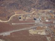
By: Dave


Comments
Fuel Prices
Fuel pumps are available 24 hrs (self-serve).
what are fuel prices - avgas
what are fuel prices for avgas