Login
Register


DED
Deland Municipal-Sidney H Taylor Field Airport
Official FAA Data Effective 2026-01-22 0901Z
Chart Supplement

VFR Chart of KDED
Sectional Charts at SkyVector.com
IFR Chart of KDED
Enroute Charts at SkyVector.com
Location Information for KDED
Coordinates: N29°4.02' / W81°17.03'Located 03 miles NE of Deland, Florida on 1289 acres of land. View all Airports in Florida.
Surveyed Elevation is 79 feet MSL.
Operations Data
|
|
Airport Communications
| AWOS-3: | 119.575 Tel. 386-740-5811 |
|---|---|
| DAYTONA APPROACH: | 125.35 322.3 |
| DAYTONA DEPARTURE: | 125.35 322.3 |
| UNICOM: | 123.075 |
| CTAF: | 123.075 |
| TTHOR STAR: | 118.85 353.825 |
| ASOS at DAB (12.8 NE): | 386-232-5134 |
| ATIS at DAB (13.6 NE): | 132.875 |
| AWOS-3 at OMN (16.6 NE): | 118.475 386-615-7084 |
Nearby Navigation Aids
|
| ||||||||||||||||||||||||||||||||||||||||||


Runway 12/30
| Dimensions: | 6001 x 100 feet / 1829 x 30 meters | |
|---|---|---|
| Surface: | Asphalt in Fair Condition | |
| Weight Limits: | 35 /F/B/X/T, D-60 | |
| Edge Lighting: | High Intensity | |
| Runway 12 | Runway 30 | |
| Coordinates: | N29°4.34' / W81°17.56' | N29°3.89' / W81°16.55' |
| Elevation: | 73.9 | 70.1 |
| Traffic Pattern: | Left | Left |
| Runway Heading: | 117° True | 297° True |
| Markings: | Non-Precision Instrument in poor condition. | Non-Precision Instrument in poor condition. |
| Glide Slope Indicator | P2L (3.00° Glide Path Angle) | P4L (3.00° Glide Path Angle) |
| REIL: | Yes | Yes |
| Obstacles: | 26 ft Trees 1105 ft from runway, 75 ft left of center | 66 ft Trees 2220 ft from runway, 235 ft right of center |
Runway 05/23
| Dimensions: | 4301 x 75 feet / 1311 x 23 meters | |
|---|---|---|
| Surface: | Asphalt in Fair Condition | |
| Weight Limits: | 14 /F/B/Y/T, D-40 | |
| Edge Lighting: | Medium Intensity | |
| Runway 05 | Runway 23 | |
| Coordinates: | N29°3.65' / W81°17.29' | N29°4.12' / W81°16.68' |
| Elevation: | 78.3 | 67.9 |
| Traffic Pattern: | Left | Left |
| Runway Heading: | 48° True | 228° True |
| Markings: | Non-Precision Instrument in poor condition. | Non-Precision Instrument in poor condition. |
| Glide Slope Indicator | P2L (3.00° Glide Path Angle) | P2L (3.00° Glide Path Angle) |
| Obstacles: | 50 ft Trees 1455 ft from runway, 230 ft left of center | 54 ft Trees 2055 ft from runway, 200 ft left of center |
Services Available
| Fuel: | 100LL (blue), Jet-A, UL94 |
|---|---|
| Transient Storage: | Hangars,Tiedowns |
| Airframe Repair: | MAJOR |
| Engine Repair: | MAJOR |
| Bottled Oxygen: | NONE |
| Bulk Oxygen: | NONE |
| Other Services: | AVIONICS,PILOT INSTRUCTION,PARACHUTE JUMP ACTIVITY,AIRCRAFT RENTAL |
Ownership Information
| Ownership: | Publicly owned | |
|---|---|---|
| Owner: | CITY OF DELAND | |
| 120 S FLORIDA AVE | ||
| DELAND, FL 32720 | ||
| 386-626-7107 | ||
| Manager: | JOHN EIFF | ARPT PHYS ADS: 1000 FLIGHTLINE BLVD. |
| 1000 FLIGHTLINE BLVD | ||
| DELAND, FL 32724 | ||
| 386-626-7240 | ||
Other Remarks
- UNLIGTD OBSTNS IN THE APCH TO RWY 05 DUE TO TREES 51 FT TALL 1455 FT BFR AER.
- TOUCH & GO OPNS PROHIBITED IF THERE ARE 3 OR MORE ACFT IN THE TFC PATTERN.
- NOISE ABATEMENT PROCEDURES IN EFFECT, CALL AMGR (386) 740-6955.
- EXTSV PARACHUTE & FLT TRNG OPNS. AVOID OVER FLYING ARPT DURG PARACHUTE OPNS.
- NOISE SENSITIVE ARPT. AVOID OVER FLT OF RESIDENTIAL AREA S OF ARPT; AVOID WIDE DOWNWIND RY 23. JET ACFT USE NBAA NOISE ABATEMENT PROCEDURES.
- CALM WIND RY 05.
- LMTD SIGHT DISTANCES ALL RYS.
- CTC UNICOM FOR TIE DOWN INFO.
- FOR CD OR TO CNL IFR CTC DAYTONA APCH AT 386-226-3939.
- RWY 05 MRKGS FADED & DISCOLORED.
- RWY 12 MRKGS FADED & DISCOLORED.
- RWY 23 MRKGS FADED & DISCOLORED.
- RWY 30 MRKGS FADED & DISCOLORED.
- 0LL SELF SERVE 100LL AVBL 24 HRS WITH CREDIT CARD.
- ACTVT REIL RWY 12 & 30; PAPI RWY 30; MIRL RWY 05/23, HIRL RWY 12/30 - CTAF. PAPI RWY 05, 12, & 23 OPER CONSLY.
Weather Minimums

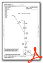
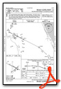
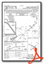
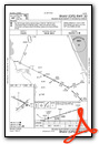
Standard Terminal Arrival (STAR) Charts
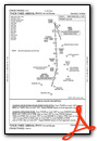
Instrument Approach Procedure (IAP) Charts
Nearby Airports with Instrument Procedures
| ID | Name | Heading / Distance | ||
|---|---|---|---|---|
 |
7FL6 | Spruce Creek Airport | 086° | 12.5 |
|
KDAB | Daytona Beach International Airport | 060° | 13.7 |
|
KOMN | Ormond Beach Municipal Airport | 032° | 16.6 |
|
KEVB | New Smyrna Beach Municipal (Jack Bolt Field) Airport | 092° | 17.6 |
|
KSFB | Orlando Sanford International Airport | 171° | 17.5 |
|
X50 | Massey Ranch Airpark Airport | 105° | 19.6 |
|
X23 | Umatilla Municipal Airport | 246° | 21.2 |
|
KFIN | Flagler Exec Airport | 009° | 24.2 |
|
X04 | Orlando Apopka Airport | 216° | 26.7 |
|
KLEE | Leesburg International Airport | 242° | 31.2 |
|
KORL | Orlando Exec Airport | 184° | 31.3 |
|
X21 | Arthur Dunn Air Park Airport | 138° | 35.6 |
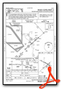
Airport Images
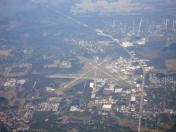
By: Dave


