Login
Register


DYA
Demopolis Regional Airport
Official FAA Data Effective 2024-04-18 0901Z
Chart Supplement

VFR Chart of KDYA
Sectional Charts at SkyVector.com
IFR Chart of KDYA
Enroute Charts at SkyVector.com
Location Information for KDYA
Coordinates: N32°27.83' / W87°57.24'Located 06 miles SW of Demopolis, Alabama on 438 acres of land. View all Airports in Alabama.
Surveyed Elevation is 111 feet MSL.
Operations Data
|
|
Airport Communications
| AWOS-3P: | 119.475 Tel. 334-289-1466 |
|---|---|
| MERIDIAN APPROACH: | 121.275 348.7 |
| MERIDIAN DEPARTURE: | 121.275 348.7 |
| CTAF: | 122.800 |
| UNICOM: | 122.800 |
| AWOS-3P at A08 (29.0 E): | 119.350 334-683-4423 |
| ATIS at NMM (30.9 W): | 290.525 |
| ATIS at MEI (41.2 W): | 291.675 |
- APCH/DEP SVC PRVDD BY ATLANTA ARTCC ON FREQS 132.25/263.025 (UNIONTOWN RCAG) WHEN MERIDIAN APCH CTL CLSD.
Nearby Navigation Aids
|
| ||||||||||||||||||||||||||||||||||||||||||||||||||||||


Runway 04/22
| Dimensions: | 5002 x 100 feet / 1525 x 30 meters 20 FT SHOULDERS ON BOTH SIDES OF RWY. | |
|---|---|---|
| Surface: | Asphalt in Good Condition | |
| Weight Limits: | S-30, D-38, ST-60 | |
| Edge Lighting: | Medium Intensity | |
| Runway 04 | Runway 22 | |
| Coordinates: | N32°27.53' / W87°57.57' | N32°28.13' / W87°56.91' |
| Elevation: | 111.7 | 105.3 |
| Traffic Pattern: | Left | Left |
| Runway Heading: | 43° True | 223° True |
| Markings: | Non-Precision Instrument in good condition. | Non-Precision Instrument in good condition. |
| Glide Slope Indicator | P2R (3.25° Glide Path Angle) | P2L (3.25° Glide Path Angle) |
| Obstacles: | 17 ft Trees 429 ft from runway, 234 ft left of center | 139 ft Trees 2026 ft from runway, 307 ft left of center |
Services Available
| Fuel: | 100LL (blue), Jet A+ |
|---|---|
| Transient Storage: | Hangars,Tiedowns |
| Airframe Repair: | MINOR |
| Engine Repair: | MINOR |
| Bottled Oxygen: | NONE |
| Bulk Oxygen: | NONE |
| Other Services: | PILOT INSTRUCTION,AIRCRAFT RENTAL |
Ownership Information
| Ownership: | Publicly owned | |
|---|---|---|
| Owner: | CITY OF DEMOPOLIS | |
| PO BOX 580 | ||
| DEMOPOLIS, AL 36732 | ||
| 334-289-0577 | ||
| Manager: | JASON PENDERGRASS | |
| 744 BOYKIN FIELD ROAD | ||
| DEMOPOLIS, AL 36732 | ||
| 334-289-0455 | ||
Operational Statistics
| Single Engine Aircraft Based on Field: | 14 | Statistics collected for 12 month period ending 2017-11-01 | |
|---|---|---|---|
| Multi-Engine Aircraft Based on Field: | 1 | Annual Commercial Operations: | none |
| Jet Aircraft Based on Field: | none | Annual Commuter Operations: | none |
| Helicopters Based on Field: | 2 | Annual Air Taxi Operations: | none |
| Military Aircraft Based on Field: | none | Annual Military Operations: | 75 |
| Gliders Based on Field: | none | Annual GA Local Operations: | 755 |
| Ultralights Based on Field: | none | Annual GA Itinerant Operations: | 4420 |
Other Remarks
- DEER ON AND INVOF ARPT.
- FOR CD CTC MERIDIAN APCH 601-679-3691, WHEN MERIDIAN APCH CLSD CTC ATLANTA ARTCC AT 770-210-7692.
- ACTVT PAPI RWY 04 & 22; MIRL RWY 04/22 - CTAF.
Weather Minimums

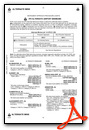
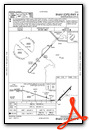
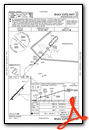
Instrument Approach Procedure (IAP) Charts
Nearby Airports with Instrument Procedures
| ID | Name | Heading / Distance | ||
|---|---|---|---|---|
 |
7A0 | Greensboro Municipal Airport | 048° | 19.7 |
|
09A | Butler/Choctaw County Airport | 203° | 22.4 |
|
A08 | Vaiden Field Airport | 084° | 29.0 |
|
KNMM | Meridian NAS (Mc Cain Field) Airport | 280° | 31.0 |
|
KAIV | George Downer Airport | 342° | 40.4 |
|
KMEI | Key Field Airport | 259° | 41.3 |
|
61A | Camden Municipal Airport | 132° | 42.7 |
|
KTCL | Tuscaloosa Ntl Airport | 020° | 48.5 |
|
KSEM | Craig Field Airport | 098° | 49.6 |
|
0A8 | Bibb County Airport | 056° | 52.1 |
|
3M8 | North Pickens Airport | 357° | 55.3 |
|
4R3 | Jackson Municipal Airport | 177° | 59.5 |
Airport Images
Do you have a recent image of this airport? Upload it here!


