Login
Register


FIT
Fitchburg Municipal Airport
Official FAA Data Effective 2026-02-19 0901Z
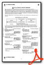
Chart Supplement

VFR Chart of KFIT
Sectional Charts at SkyVector.com
IFR Chart of KFIT
Enroute Charts at SkyVector.com
Location Information for KFIT
Coordinates: N42°33.23' / W71°45.55'Located 03 miles SE of Fitchburg, Massachusetts on 376 acres of land. View all Airports in Massachusetts.
Surveyed Elevation is 344 feet MSL.
Operations Data
|
|
Airport Communications
| ASOS: | 135.175 Tel. 978-343-9121 |
|---|---|
| BOSTON APPROACH: | 124.4 279.6 |
| BOSTON DEPARTURE: | 124.4 279.6 |
| CTAF: | 122.700 |
| UNICOM: | 122.700 |
| AWOS-3PT at ASH (17.4 NE): | 125.1 603-578-0473 |
| ATIS at ASH (17.5 NE): | 125.1 |
| ATIS at ORH (18.0 S): | 126.55 |
Nearby Navigation Aids
|
| ||||||||||||||||||||||||||||||||||||||||||||||||||||||||||||


Runway 14/32
| Dimensions: | 5001 x 100 feet / 1524 x 30 meters | |
|---|---|---|
| Surface: | Asphalt / Grooved in Excellent Condition | |
| Weight Limits: | S-30, D-41 | |
| Edge Lighting: | Medium Intensity | |
| Runway 14 | Runway 32 | |
| Coordinates: | N42°33.50' / W71°45.98' | N42°32.97' / W71°45.12' |
| Elevation: | 344.5 | 328.5 |
| Traffic Pattern: | Left | Left |
| Runway Heading: | 130° True | 310° True |
| Displaced Threshold: | 163 Feet | 300 Feet |
| Declared Distances: | TORA:5001 TODA:5001 ASDA:4701 LDA:4538 | TORA:5001 TODA:5001 ASDA:4838 LDA:4538 |
| Markings: | Non-Precision Instrument in good condition. | Non-Precision Instrument in good condition. |
| Glide Slope Indicator | P4L (3.00° Glide Path Angle) PAPI UNUSBL BYD 5 DEGS L & R OF CNTRLN. | P4L (3.50° Glide Path Angle) |
| REIL: | Yes | Yes |
| Obstacles: | 50 ft Trees 600 ft from runway, 125 ft left of center | 42 ft Trees 800 ft from runway, 125 ft right of center |
Services Available
| Fuel: | 100LL (blue), Jet-A, Jet A+ |
|---|---|
| Transient Storage: | Hangars,Tiedowns |
| Airframe Repair: | MAJOR |
| Engine Repair: | MAJOR |
| Bottled Oxygen: | NONE |
| Bulk Oxygen: | NONE |
| Other Services: | AIR AMBULANCE SERVICES,AVIONICS,CHARTER SERVICE,GLIDER SERVICE,PILOT INSTRUCTION,AIRCRAFT RENTAL PWRD PARAGLIDERS. |
Ownership Information
| Ownership: | Publicly owned | |
|---|---|---|
| Owner: | CITY OF FITCHBURG | |
| CITY HALL, 718 MAIN ST | ||
| FITCHBURG, MA 01420 | ||
| 978-829-1800 | ||
| Manager: | RUSSEL CORNELIA | |
| FITCHBURG MUNICIPAL AIRPORT, 567 CRAWFORD ST | ||
| FITCHBURG, MA 01420 | ||
| 618-681-1771 | PKETTLE@FITCHBURGMA.GOV. | |
Other Remarks
- WILDLIFE ON & INVOF ARPT.
- FOR CD CTC BOSTON APCH AT 603-594-5552.
- COLD TEMPERATURE AIRPORT. ALTITUDE CORRECTION REQUIRED AT OR BELOW -21C.
- NOISE SENSITIVE AREA: DEP ACFT CLIMB TO TPA BFR TURNING CROSSWIND.
- ACTVT REIL RWY 14 & 32; PAPI RWY 14 & 32; MIRL RWY 14/32 - 123.0.
Weather Minimums

Instrument Approach Procedure (IAP) Charts


Nearby Airports with Instrument Procedures
| ID | Name | Heading / Distance | ||
|---|---|---|---|---|
 |
KGDM | Gardner Municipal Airport | 268° | 11.4 |
|
6B6 | Minute Man Air Field Airport | 117° | 12.1 |
|
KASH | Boire Field Airport | 038° | 17.5 |
|
KORH | Worcester Regional Airport | 196° | 18.0 |
|
KAFN | Jaffrey Airfield Silver Ranch Airport | 324° | 18.5 |
|
KBED | Laurence G Hanscom Field Airport | 103° | 21.5 |
|
KORE | Orange Municipal Airport | 272° | 23.5 |
|
KMHT | Manchester Boston Regional Airport | 032° | 26.9 |
|
1B6 | Hopedale Industrial Park Airport | 157° | 29.0 |
|
KLWM | Lawrence Municipal Airport | 070° | 29.8 |
|
3B0 | Southbridge Municipal Airport | 204° | 29.9 |
|
KEEN | Dillant/Hopkins Airport | 312° | 30.6 |
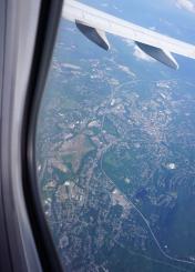
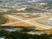
Airport Images
By: Shalinij
By: charley valera


