Login
Register


GOK
Guthrie/Edmond Regional Airport
Official FAA Data Effective 2025-12-25 0901Z
Chart Supplement

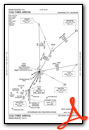
VFR Chart of KGOK
Sectional Charts at SkyVector.com
IFR Chart of KGOK
Enroute Charts at SkyVector.com
Location Information for KGOK
Coordinates: N35°51.09' / W97°24.97'Located 02 miles S of Guthrie, Oklahoma on 411 acres of land. View all Airports in Oklahoma.
Surveyed Elevation is 1069 feet MSL.
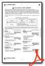
Operations Data
|
|
Airport Communications
| ASOS: | 133.975 Tel. 405-282-0478 |
|---|---|
| OKE CITY APPROACH: | 124.2 336.4 |
| OKE CITY DEPARTURE: | 124.2 336.4 |
| CTAF: | 122.800 |
| UNICOM: | 122.800 |
| AWOS-3 at HSD (20.7 SW): | 120.975 405-283-9848 |
| ASOS at PWA (22.1 SW): | 405-798-2013 |
| ATIS at PWA (22.1 SW): | 128.725 |
Nearby Navigation Aids
|
| ||||||||||||||||||||||||||||||||||||||||||||||||||||||||||||


Runway 16/34
RWY 16 CALM WIND RWY. | ||
| Dimensions: | 5001 x 75 feet / 1524 x 23 meters | |
|---|---|---|
| Surface: | Concrete in Good Condition | |
| Weight Limits: | S-30, D-48, ST-78 | |
| Edge Lighting: | Medium Intensity | |
| Runway 16 | Runway 34 | |
| Coordinates: | N35°51.49' / W97°25.10' | N35°50.69' / W97°24.84' |
| Elevation: | 1049.6 | 1066.0 |
| Traffic Pattern: | Left | Left |
| Runway Heading: | 165° True | 345° True |
| Markings: | Non-Precision Instrument in good condition. | Non-Precision Instrument in good condition. |
| Glide Slope Indicator | P4L (3.00° Glide Path Angle) | P4L (3.00° Glide Path Angle) |
| Approach Lights: | ODALS Omnidirectional Approach Lighting System | |
| REIL: | Yes | Yes |
| Obstacles: | 23 ft Trees 489 ft from runway, 218 ft left of center | |
Services Available
| Fuel: | 100LL (blue), Jet-A |
|---|---|
| Transient Storage: | Hangars,Tiedowns FOR HNGR AVBLTY CTC FBO (405) 282-4250. |
| Airframe Repair: | MAJOR |
| Engine Repair: | MAJOR |
| Bottled Oxygen: | NONE |
| Bulk Oxygen: | NONE |
| Other Services: | PILOT INSTRUCTION,AIRCRAFT RENTAL |
Ownership Information
| Ownership: | Publicly owned | |
|---|---|---|
| Owner: | CITY OF GUTHRIE | |
| PO BOX 908, 101 N. SECOND ST. | ||
| GUTHRIE, OK 73044 | ||
| 405-282-0488 | ||
| Manager: | CADEN YOUNG | |
| 520 AIRPORT RD | ||
| GUTHRIE, OK 73044 | ||
| 405-282-2312 | ||
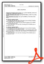
Other Remarks
- FOR CD CTC OKE CITY APCH AT 405-681-5683
- CTN: BIRD AND OTR WILDLIFE ACT ON AND INVOF ARPT.
- ACTVT ODALS RWY 16; REIL RWY 34 - CTAF. MIRL RWY 16/34 SS-SR PRESET MED INTST; INCR INTST - CTAF. PAPI RWY 16 & 34 ON CONSLY.
Weather Minimums
Standard Terminal Arrival (STAR) Charts
Instrument Approach Procedure (IAP) Charts


Nearby Airports with Instrument Procedures
| ID | Name | Heading / Distance | ||
|---|---|---|---|---|
 |
KHSD | Sundance Airport | 223° | 20.6 |
|
KPWA | Wiley Post Airport | 210° | 22.1 |
|
KSWO | Stillwater Regional Airport | 040° | 24.6 |
|
KTIK | Tinker AFB Airport | 176° | 26.2 |
|
KOKC | Okc Will Rogers International Airport | 198° | 28.9 |
|
KRCE | Clarence E Page Municipal Airport | 222° | 29.5 |
|
KCQB | Chandler Regional Airport | 104° | 30.1 |
|
KCUH | Cushing Municipal Airport | 079° | 31.9 |
|
F22 | Perry Municipal Airport | 011° | 32.7 |
|
KWDG | Enid Woodring Regional Airport | 330° | 36.3 |
|
KOUN | University of Oklahoma Westheimer Airport | 184° | 36.4 |
|
KRQO | El Reno Regional Airport | 231° | 36.7 |
Airport Images
Do you have a recent image of this airport? Upload it here!


