Login
Register


HVR
Havre City-County Airport
Official FAA Data Effective 2025-12-25 0901Z
Chart Supplement

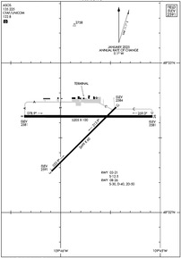
KHVR Airport Diagram
VFR Chart of KHVR
Sectional Charts at SkyVector.com
IFR Chart of KHVR
Enroute Charts at SkyVector.com
Location Information for KHVR
Coordinates: N48°32.58' / W109°45.74'Located 03 miles W of Havre, Montana on 720 acres of land. View all Airports in Montana.
Surveyed Elevation is 2591 feet MSL.
Operations Data
|
|
Airport Communications
| ASOS: | 135.225 Tel. 406-265-6638 |
|---|---|
| CTAF: | 122.800 |
| UNICOM: | 122.800 |
| AWOS-AV at S71 (20.6 E): | 118.35 406-357-3453 |
| AWOS-3PT at 79S (54.6 SW): | 121.125 406-622-5976 |
| AWOS-3 at M75 (74.2 E): | 119.250 406 654 1279 |
- COMMUNICATIONS PRVDD BY GREAT FALLS RADIO ON FREQ 122.5 (HAVRE RCO).
- APCH/DEP CTL SVC PRVDD BY SALT LAKE ARTCC (ZLC) ON 133.4/285.4 (JUDITH MOUNTAIN RCAG).
Nearby Navigation Aids
|
| ||||||||||||||||||||||||


Runway 08/26
| Dimensions: | 5205 x 100 feet / 1586 x 30 meters | |
|---|---|---|
| Surface: | Asphalt in Excellent Condition | |
| Weight Limits: | S-30, D-40, ST-50 | |
| Edge Lighting: | Medium Intensity | |
| Runway 08 | Runway 26 | |
| Coordinates: | N48°32.64' / W109°46.37' | N48°32.64' / W109°45.08' |
| Elevation: | 2581.4 | 2580.5 |
| Traffic Pattern: | Left | Left |
| Runway Heading: | 90° True | 270° True |
| Declared Distances: | TORA:5205 TODA:5205 ASDA:5205 LDA:5205 | TORA:5205 TODA:5205 ASDA:5205 LDA:5205 |
| Markings: | Non-Precision Instrument in good condition. | Non-Precision Instrument in good condition. |
| Glide Slope Indicator | V4L (3.00° Glide Path Angle) | V4L (3.00° Glide Path Angle) |
| REIL: | Yes | Yes |
Runway 03/21
| Dimensions: | 3699 x 60 feet / 1127 x 18 meters | |
|---|---|---|
| Surface: | Asphalt in Excellent Condition | |
| Weight Limits: | S-12 | |
| Edge Lighting: | Medium Intensity | |
| Runway 03 | Runway 21 | |
| Coordinates: | N48°32.27' / W109°46.09' | N48°32.70' / W109°45.44' |
| Elevation: | 2590.7 | 2584.4 |
| Runway Heading: | 45° True | 225° True |
| Declared Distances: | TORA:3699 TODA:3699 ASDA:3699 LDA:3699 | TORA:3699 TODA:3699 ASDA:3699 LDA:3699 |
| Markings: | Basic in good condition. | Basic in good condition. |
| Glide Slope Indicator | P2R (3.00° Glide Path Angle) | |
Services Available
| Fuel: | 100LL (blue), Jet A+ |
|---|---|
| Transient Storage: | Hangars,Tiedowns |
| Airframe Repair: | MINOR |
| Engine Repair: | MINOR |
| Bottled Oxygen: | NONE |
| Bulk Oxygen: | NONE |
| Other Services: | AIR FREIGHT SERVICES,CROP DUSTING SERVICES,AIR AMBULANCE SERVICES,CARGO HANDLING SERVICES |
Ownership Information
| Ownership: | Publicly owned | |
|---|---|---|
| Owner: | CITY OF HAVRE & HILL CO | |
| 520 4 TH ST, PO BOX 231 | ||
| HAVRE, MT 59501 | ||
| (406) 265-6719 | ||
| Manager: | TONY DOLPHAY | |
| 5180 9TH ST W, P.O. BOX 231 | ||
| HAVRE, MT 59501 | ||
| 406-265-4326 | CELL NUMBER 406-390-5689 | |
Other Remarks
- THIS AIRPORT HAS BEEN SURVEYED BY THE NATIONAL GEODETIC SURVEY.
- POTENTIAL LARGE FLOCKS OF WATERFOWL NEAR APPROACH END RY 26.
- FOR CD IF UNA TO CTC ON FSS FREQ, CTC SALT LAKE ARTCC AT 801-320-2568.
- ACTVT REIL RWY 08 & 26; PAPI RWY 21; VASI RWY 08 & 26; MIRL RWY 03/21 - CTAF
Weather Minimums

Instrument Approach Procedure (IAP) Charts

Nearby Airports with Instrument Procedures
| ID | Name | Heading / Distance | ||
|---|---|---|---|---|
 |
79S | Fort Benton Airport | 220° | 54.7 |
|
M75 | Malta Airport | 097° | 74.4 |
|
KSBX | Shelby Airport | 270° | 84.1 |
|
S64 | Stanford/Biggerstaff Field Airport | 192° | 85.9 |
|
KLWT | Lewistown Municipal Airport | 172° | 90.5 |
|
KGTF | Great Falls International Airport | 226° | 90.8 |
|
S01 | Conrad Airport | 256° | 91.4 |
|
KCTB | Cut Bank International Airport | 273° | 104.2 |
|
KCII | Choteau Airport | 246° | 105.7 |
|
KHLN | Helena Regional Airport | 218° | 147.1 |
Airport Images
Do you have a recent image of this airport? Upload it here!


Comments
New FBO
The FBO in Havre(HVR) is under new ownership (MRKT AVIATION). They are available and responsive. Give them a try as you fly through, you won't be disappointed.