Login
Register
LCH
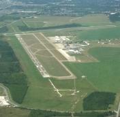
Lake Charles Regional Airport
Official FAA Data Effective 2026-01-22 0901Z
VFR Chart of KLCH
Sectional Charts at SkyVector.com
IFR Chart of KLCH
Enroute Charts at SkyVector.com
Location Information for KLCH
Coordinates: N30°7.57' / W93°13.40'Located 05 miles S of Lake Charles, Louisiana on 1878 acres of land. View all Airports in Louisiana.
Surveyed Elevation is 14 feet MSL.
Operations Data
|
|
Airport Communications
| ATIS: | 118.75 |
|---|---|
| ASOS: | Tel. 337-240-9596 |
| LAKE CHARLES TOWER: | 120.7 257.8 |
| LAKE CHARLES GROUND: | 121.8 |
| LAKE CHARLES APPROACH: | 119.35 ;WEST 119.8 ;EAST 282.3 ;EAST 353.75 ;WEST |
| LAKE CHARLES DEPARTURE: | 119.35 ;WEST 119.8 ;EAST 282.3 ;EAST 353.75 ;WEST |
| IC: | 119.35 ;WEST 353.75 ;WEST |
| CLEARANCE DELIVERY: | 126.25 |
| CTAF: | 120.700 |
| TRSA: | 119.35 ;WEST 119.8 ;EAST 282.3 ;EAST 353.75 ;WEST |
| UNICOM: | 122.950 |
| HEL OPS: | 119.75 ;OFFSHORE HELICOPTER OPERATIONS |
| EMERG: | 121.5 243.0 |
| AWOS-3 at CWF (6.6 NE): | 120.0 337-214-2134 |
| ATIS at CWF (6.6 NE): | 120.0 |
| AWOS-3PT at UXL (7.9 W): | 118.175 337-558-5321 |
- APCH/DEP SVC PRVDD BY HOUSTON ARTCC (ZHU) ON FREQS 124.7/317.4 (LAKE CHARLES RCAG) WHEN LAKE CHARLES APCH CTL (LCH) CLSD.
Nearby Navigation Aids
|
| ||||||||||||||||||||||||||||||||||||||||||||||||||||||||||||
Runway 15/33
| Dimensions: | 6500 x 150 feet / 1981 x 46 meters | |
|---|---|---|
| Surface: | Concrete / Grooved in Good Condition SOUTH 900 FT GRVD. | |
| Weight Limits: | S-100, D-145, ST-260
PCR VALUE: 287/R/D/X/T
| |
| Edge Lighting: | High Intensity | |
| Runway 15 | Runway 33 | |
| Coordinates: | N30°7.72' / W93°13.68' | N30°6.75' / W93°13.15' |
| Elevation: | 11.2 | 9.8 |
| Traffic Pattern: | Right | Left |
| Runway Heading: | 155° True | 335° True |
| Declared Distances: | TORA:6500 TODA:6500 ASDA:6500 LDA:6500 | TORA:6500 TODA:6500 ASDA:6500 LDA:6500 |
| Markings: | Precision Instrument in good condition. | Precision Instrument in good condition. |
| Glide Slope Indicator | P4L (3.00° Glide Path Angle) | P4R (3.00° Glide Path Angle) |
| RVR Equipment | Touchdown Midfield | Midfield |
| Approach Lights: | MALSR 1,400 Foot Medium-intensity Approach Lighting System with runway alignment indicator lights. | MALSF 1,400 Foot Medium-intensity Approach Lighting System with sequenced flashers. |
| Obstacles: | 28 ft Pole 1412 ft from runway, 421 ft left of center | |
Runway 05/23
| Dimensions: | 5200 x 100 feet / 1585 x 30 meters | |
|---|---|---|
| Surface: | Asphalt in Good Condition | |
| Weight Limits: | S-70, D-90, ST-140
PCR VALUE: 89/F/D/X/T
| |
| Edge Lighting: | Medium Intensity | |
| Runway 05 | Runway 23 | |
| Coordinates: | N30°7.71' / W93°13.78' | N30°8.24' / W93°13.01' |
| Elevation: | 10.1 | 14.5 |
| Traffic Pattern: | Left | Right |
| Runway Heading: | 52° True | 232° True |
| Declared Distances: | TORA:5200 TODA:5200 ASDA:5200 LDA:5200 | TORA:5200 TODA:5200 ASDA:5200 LDA:5200 |
| Markings: | Non-Precision Instrument in fair condition. | Non-Precision Instrument in fair condition. |
| Glide Slope Indicator | P4L (3.00° Glide Path Angle) | V4L (3.00° Glide Path Angle) |
| REIL: | Yes | Yes |
| Obstacles: | 65 ft Tree 1620 ft from runway, 455 ft right of center | |
Services Available
| Fuel: | 100LL (blue), Jet A-1+ |
|---|---|
| Transient Storage: | Hangars,Tiedowns |
| Airframe Repair: | MAJOR |
| Engine Repair: | MAJOR |
| Bottled Oxygen: | NONE |
| Bulk Oxygen: | NONE |
| Other Services: | AIR FREIGHT SERVICES,AVIONICS,CHARTER SERVICE,PILOT INSTRUCTION,AIRCRAFT RENTAL |
Ownership Information
| Ownership: | Publicly owned | |
|---|---|---|
| Owner: | CALCASIEU PARISH | |
| PO BOX 5820 | ||
| LAKE CHARLES, LA 70607 | ||
| 337-477-6051 | ||
| Manager: | HEATH ALLEN | |
| PO DRAWER 5820 | ||
| LAKE CHARLES, LA 70607-5820 | ||
| 337-477-6051 | ||
Other Remarks
- ATCT BLIND SPOT ON TWY J.
- BIRDS ON & INVOF ARPT.
- FOR CD IF UNA TO CTC ON FSS FREQ, CTC HOUSTON ARTCC AT 281-230-5622.
- WHEN ATCT CLSD ACTVT MALSR RWY 15; MALSF RWY 33; HIRL RWY 15/33; MIRL RWY 05/23 - CTAF. PAPI RWY 33 OPR CONSLY.
Weather Minimums
Instrument Approach Procedure (IAP) Charts
Nearby Airports with Instrument Procedures
| ID | Name | Heading / Distance | ||
|---|---|---|---|---|
 |
KCWF | Chennault International Airport | 039° | 6.6 |
 |
KUXL | Southland Field Airport | 272° | 8.0 |
 |
6R1 | Welsh Airport | 071° | 21.6 |
 |
5R8 | De Quincy Industrial Airpark Airport | 325° | 22.9 |
 |
3R7 | Jennings Airport | 076° | 29.4 |
 |
KORG | Orange County Airport | 263° | 30.4 |
 |
KBPT | Jack Brooks Regional Airport | 256° | 42.8 |
 |
KDRI | Beauregard Regional Airport | 351° | 42.7 |
 |
4R7 | Eunice Airport | 063° | 46.3 |
 |
KACP | Allen Parish Airport | 036° | 46.5 |
 |
KBMT | Beaumont Municipal Airport | 266° | 51.7 |
 |
45R | Hawthorne Field Airport | 283° | 55.2 |


