Login
Register


LFK
Angelina County Airport
Official FAA Data Effective 2026-01-22 0901Z
Chart Supplement

VFR Chart of KLFK
Sectional Charts at SkyVector.com
IFR Chart of KLFK
Enroute Charts at SkyVector.com
Location Information for KLFK
Coordinates: N31°14.04' / W94°45.00'Located 07 miles SW of Lufkin, Texas on 385 acres of land. View all Airports in Texas.
Surveyed Elevation is 295 feet MSL.
Operations Data
|
|
Airport Communications
| ASOS: | 120.625 Tel. 936-637-9420 |
|---|---|
| UNICOM: | 123.000 |
| CTAF: | 123.000 |
| AWOS-3PT at OCH (20.8 N): | 135.625 936-564-5074 |
| AWOS-3PT at DKR (33.9 W): | 118.775 936-545-8510 |
| AWOS-3 at JAS (42.3 SE): | 118.375 409-489-1603 |
- APCH/DEP CTL SVC PRVDD BY HOUSTON ARTCC (ZHU) ON FREQS 125.175/285.575 (LUFKIN RCAG).
Nearby Navigation Aids
|
| ||||||||||||||||||||||||||||||||||||||||||||||||||||||||||||


Runway 07/25
| Dimensions: | 5400 x 100 feet / 1646 x 30 meters | |
|---|---|---|
| Surface: | Asphalt in Good Condition | |
| Weight Limits: | S-60, D-90 | |
| Edge Lighting: | Medium Intensity | |
| Runway 07 | Runway 25 | |
| Coordinates: | N31°14.06' / W94°45.45' | N31°14.28' / W94°44.44' |
| Elevation: | 284.1 | 295.6 |
| Traffic Pattern: | Left | Left |
| Runway Heading: | 75° True | 255° True |
| Markings: | Precision Instrument in poor condition. | Non-Precision Instrument in poor condition. |
| Glide Slope Indicator | P4L (3.00° Glide Path Angle) | |
| Approach Lights: | MALSR 1,400 Foot Medium-intensity Approach Lighting System with runway alignment indicator lights. | |
| Obstacles: | 90 ft Tree 3320 ft from runway, 210 ft left of center | 75 ft Trees 530 ft from runway |
Runway 16/34
| Dimensions: | 4311 x 100 feet / 1314 x 30 meters 296 FT PAVED SWY NW END. | |
|---|---|---|
| Surface: | Asphalt in Fair Condition | |
| Weight Limits: | S-30 | |
| Edge Lighting: | Medium Intensity | |
| Runway 16 | Runway 34 | |
| Coordinates: | N31°14.21' / W94°45.21' | N31°13.55' / W94°44.93' |
| Elevation: | 289.2 | 273.6 |
| Traffic Pattern: | Left | Left |
| Runway Heading: | 160° True | 340° True |
| Displaced Threshold: | 107 Feet | |
| Markings: | Non-Precision Instrument in fair condition. | Non-Precision Instrument in fair condition. |
| Glide Slope Indicator | V4L (3.00° Glide Path Angle) | V4L (3.00° Glide Path Angle) |
| Obstacles: | 63 ft Tree 656 ft from runway, 190 ft right of center | 53 ft Trees 855 ft from runway, 170 ft left of center OBSTN CLNC 20:1 TO DSPLCD THR. |
Services Available
| Fuel: | 100LL (blue), Jet A+ |
|---|---|
| Transient Storage: | Hangars,Tiedowns |
| Airframe Repair: | MAJOR |
| Engine Repair: | MAJOR |
| Bottled Oxygen: | NONE |
| Bulk Oxygen: | NONE |
| Other Services: | AVIONICS |
Ownership Information
| Ownership: | Publicly owned | |
|---|---|---|
| Owner: | ANGELINA COUNTY | |
| COUNTY COURTHOUSE | ||
| LUFKIN, TX 75901 | ||
| 936-634-5413 | ||
| Manager: | GARY LETNEY | |
| 800 AIRPORT BLVD. | ||
| DIBOLL, TX 75941 | ||
| 936-634-7511 | ||
Other Remarks
- RWY 34 100 FT X 199 FT PAVED SAFETY AREA.
- FOR CD IF UNA TO CTC ON FSS FREQ, CTC HOUSTON ARTCC AT 281-230-5622.
- 0LL SVC FEE CHRGD FOR FUEL AFT 1900; CALL 936-635-1542.
- DUSK-DAWN. MIRL RWYS 07/25 & 16/34 PRESET MED INTST; TO INCR INTST AND ACTVT MALSR RWY 07 - CTAF.
- UNICOM MNT FM 0700-1900.
Weather Minimums


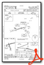
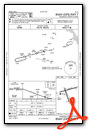
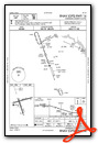
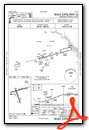
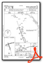
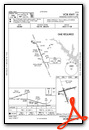
Instrument Approach Procedure (IAP) Charts

Nearby Airports with Instrument Procedures
| ID | Name | Heading / Distance | ||
|---|---|---|---|---|
 |
KOCH | Nacogdoches A L Mangham Jr Regional Airport | 005° | 20.7 |
|
KDKR | Houston County Airport | 277° | 33.9 |
|
00R | Livingston Municipal Airport | 202° | 35.6 |
|
KJAS | Jasper County/Bell Field Airport | 119° | 42.3 |
|
KJSO | Cherokee County Airport | 327° | 45.0 |
|
F17 | Center Municipal Airport | 040° | 47.0 |
|
KUTS | Huntsville Municipal Airport | 236° | 52.1 |
|
6R3 | Cleveland Municipal Airport | 194° | 54.2 |
|
KRFI | Rusk County Airport | 354° | 54.6 |
|
KPSN | Palestine Municipal Airport | 303° | 58.9 |
|
45R | Hawthorne Field Airport | 154° | 59.5 |
|
4F2 | Panola County-Sharpe Field Airport | 022° | 60.9 |
Airport Images

By: Bandco


