Login
Register


MEB
Laurinburg/Maxton Airport
Official FAA Data Effective 2026-02-19 0901Z
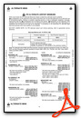
Chart Supplement

VFR Chart of KMEB
Sectional Charts at SkyVector.com
IFR Chart of KMEB
Enroute Charts at SkyVector.com
Location Information for KMEB
Coordinates: N34°47.53' / W79°21.95'Located 03 miles N of Maxton, North Carolina on 3108 acres of land. View all Airports in North Carolina.
Surveyed Elevation is 215 feet MSL.
Operations Data
|
|
Airport Communications
| ASOS: | 134.125 Tel. 910-844-5338 |
|---|---|
| FAYETTEVILLE APPROACH: | 127.8 343.725 |
| FAYETTEVILLE DEPARTURE: | 127.8 343.725 |
| CTAF: | 122.800 |
| UNICOM: | 122.800 |
| D-ATIS at HFF (16.0 NW): | 141.4 |
| ASOS at HFF (16.4 NW): | 141.25 910-396-7804 |
| ASOS at LBT (18.7 SE): | 134.775 910-739-7120 |
Nearby Navigation Aids
|
| ||||||||||||||||||||||||||||||||||||||||||||||||||||||||||||


Runway 05/23
| Dimensions: | 6503 x 100 feet / 1982 x 30 meters | |
|---|---|---|
| Surface: | Asphalt in Excellent Condition | |
| Weight Limits: | S-60, D-160, ST-256 | |
| Edge Lighting: | High Intensity | |
| Runway 05 | Runway 23 | |
| Coordinates: | N34°47.42' / W79°22.32' | N34°48.17' / W79°21.39' |
| Elevation: | 215.6 | 200.0 |
| Traffic Pattern: | Left | Right |
| Runway Heading: | 46° True | 226° True |
| Displaced Threshold: | 187 Feet | |
| Markings: | Precision Instrument in good condition. | Precision Instrument in good condition. |
| Glide Slope Indicator | P4L (3.00° Glide Path Angle) | P4L (3.00° Glide Path Angle) |
| Approach Lights: | MALSR 1,400 Foot Medium-intensity Approach Lighting System with runway alignment indicator lights. | |
| Obstacles: | 20 ft Road 534 ft from runway | |
Runway 13/31
| Dimensions: | 3536 x 75 feet / 1078 x 23 meters 2750 FT CONC STOPWAY ON SE END. | |
|---|---|---|
| Surface: | Concrete in Fair Condition | |
| Weight Limits: | S-25, D-35 | |
| Runway 13 | Runway 31 | |
| Coordinates: | N34°47.25' / W79°22.39' | N34°46.84' / W79°21.89' |
| Elevation: | 215.5 | 207.0 |
| Traffic Pattern: | Right | Left |
| Runway Heading: | 135° True | 315° True |
| Markings: | Basic in fair condition. | Basic in fair condition. |
| Obstacles: | 44 ft Trees 1721 ft from runway, 87 ft right of center | 45 ft Trees 749 ft from runway, 294 ft left of center |
Services Available
| Fuel: | 100LL (blue), Jet A-1+ |
|---|---|
| Transient Storage: | Hangars,Tiedowns |
| Airframe Repair: | MINOR CTC AMGR FOR ACFT RPR SVC. |
| Engine Repair: | MINOR |
| Bottled Oxygen: | NONE |
| Bulk Oxygen: | NONE |
| Other Services: | AIR AMBULANCE SERVICES,PILOT INSTRUCTION,PARACHUTE JUMP ACTIVITY,AIRCRAFT RENTAL |
Ownership Information
| Ownership: | Publicly owned | |
|---|---|---|
| Owner: | TOWN OF LAURINBURG & MAXTON | |
| 16701 AIRPORT RD | ||
| MAXTON, NC 28364 | ||
| 910-844-5081 | ||
| Manager: | SETH HATCHELL | |
| 16701 AIRPORT RD | ||
| MAXTON, NC 28364 | ||
| 910-390-6122 | ||
Other Remarks
- MIL ACFT FRQLY OPER FM CLSD PTN OF RWY 13/31 & CLSD RWY 18/36.
- HVY PAJA AT SOUTH END OF CLSD RWY 18/36 & SOUTH SIDE RWY 13/31.
- FARMING EQPT AND MIL OPS ON & INVOF ARPT.
- RWY 13/31 DALGT USE ONLY.
- NO LN OF SIGHT BTN RWY ENDS.
- FOR CD IF UNA VIA GCO CTC FAYETTEVILLE APCH AT 910-484-8012.
- 0LL 24 HR SELF SVC WITH CREDIT CARD.
- ACTVT MALSR RWY 05; PAPI RWY 05 & 23; HIRL RWY 05/23 - CTAF.
Weather Minimums

Instrument Approach Procedure (IAP) Charts


Nearby Airports with Instrument Procedures
| ID | Name | Heading / Distance | ||
|---|---|---|---|---|
 |
5W4 | P K Airpark Airport | 032° | 16.1 |
|
KLBT | Lumberton Regional Airport | 125° | 18.7 |
|
KRCZ | Richmond County Airport | 287° | 20.3 |
|
KDLC | Dillon County Airport | 180° | 20.6 |
|
KBBP | Marlboro County Jetport/H E Avent Field Airport | 240° | 20.9 |
|
KFAY | Fayetteville Regional/Grannis Field Airport | 063° | 26.8 |
|
KSOP | Moore County Airport | 357° | 26.7 |
|
KPOB | Pope AAF Airport | 037° | 28.5 |
|
KCQW | Cheraw Municipal/Lynch Bellinger Field Airport | 260° | 29.6 |
|
KUDG | Darlington County Airport | 231° | 33.0 |
|
KMAO | Marion County Airport | 177° | 36.6 |
|
KAFP | Anson County/Jeff Cloud Field Airport | 291° | 37.7 |
Airport Images
")
By: N714AJ
")
By: N714AJ


