Login
Register


MTJ
Montrose Regional Airport
Official FAA Data Effective 2024-04-18 0901Z
Chart Supplement

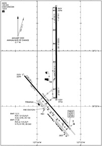
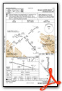
KMTJ Airport Diagram
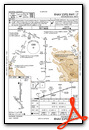
VFR Chart of KMTJ
Sectional Charts at SkyVector.com
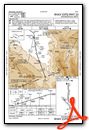
IFR Chart of KMTJ
Enroute Charts at SkyVector.com
Location Information for KMTJ
Coordinates: N38°30.59' / W107°53.65'Located 01 miles NW of Montrose, Colorado on 966 acres of land. View all Airports in Colorado.
Surveyed Elevation is 5758 feet MSL.
Operations Data
|
|
Airport Communications
| ASOS: | 135.225 Tel. 970-249-1534 |
|---|---|
| UNICOM: | 122.800 |
| CTAF: | 122.800 |
| AWOS-3 at AJZ (18.5 NW): | 134.0 970-874-3251 |
| AWOS-3 at TEX (33.4 S): | 118.325 970-728-1534 |
| AWOS-3 at AIB (35.6 SW): | 132.525 970-864-2325 |
- APCH/DEP CTLSVC PRVDD BY DENVER ARTCC (ZDV) ON 127.1(GRAND MESA/A/ RCAG & MONTROSE RCAG) 343.65 (MESA/A RCAG).
Nearby Navigation Aids
|
| ||||||||||||||||||||||||||||||||||||

Runway 17/35
RCMDD FOR APCH SPD MORE THAN 121 KT. | ||
| Dimensions: | 10000 x 150 feet / 3048 x 46 meters | |
|---|---|---|
| Surface: | Asphalt / Grooved in Good Condition | |
| Weight Limits: | 61 /F/C/X/T, S-75, D-190, ST-265 | |
| Edge Lighting: | High Intensity | |
| Runway 17 | Runway 35 | |
| Coordinates: | N38°31.79' / W107°53.56' | N38°30.14' / W107°53.56' |
| Elevation: | 5693.7 | 5734.1 |
| Runway Heading: | 180° True | 360° True |
| Declared Distances: | TORA:10000 TODA:10000 ASDA:10000 LDA:10000 | TORA:10000 TODA:10000 ASDA:10000 LDA:10000 |
| Markings: | Precision Instrument in good condition. | Precision Instrument in good condition. |
| Glide Slope Indicator | P4L (3.00° Glide Path Angle) | P4L (3.00° Glide Path Angle) |
| Approach Lights: | MALSR 1,400 Foot Medium-intensity Approach Lighting System with runway alignment indicator lights. | |
| REIL: | Yes | |
Runway 13/31
RCMDD FOR APCH SPD LESS THAN 121 KT. | ||
| Dimensions: | 7510 x 100 feet / 2289 x 30 meters | |
|---|---|---|
| Surface: | Asphalt / Grooved in Good Condition | |
| Weight Limits: | 13 /F/D/X/T, S-65, D-90, ST-150 | |
| Edge Lighting: | High Intensity | |
| Runway 13 | Runway 31 | |
| Coordinates: | N38°30.55' / W107°54.29' | N38°29.61' / W107°53.27' |
| Elevation: | 5698.5 | 5758.5 |
| Traffic Pattern: | Left | Left |
| Runway Heading: | 139° True | 319° True |
| Declared Distances: | TORA:7510 TODA:7510 ASDA:7510 LDA:7510 | TORA:7510 TODA:7510 ASDA:7510 LDA:7510 |
| Markings: | Non-Precision Instrument in good condition. | Non-Precision Instrument in good condition. |
| Glide Slope Indicator | V4L (3.00° Glide Path Angle) | V4L (3.00° Glide Path Angle) |
| REIL: | Yes | |
| Obstacles: | 41 ft Tree 2050 ft from runway, 575 ft right of center THREE MKD & LGTD POLES 1.5 MI NW RWY END. |
|
Services Available
| Fuel: | 100LL (blue), Jet A+ |
|---|---|
| Transient Storage: | Hangars,Tiedowns |
| Airframe Repair: | MAJOR |
| Engine Repair: | MAJOR |
| Bottled Oxygen: | HIGH |
| Bulk Oxygen: | HIGH |
| Other Services: | AIR AMBULANCE SERVICES,PILOT INSTRUCTION,AIRCRAFT RENTAL |
Ownership Information
| Ownership: | Publicly owned | |
|---|---|---|
| Owner: | MONTROSE COUNTY | |
| 161 S. TOWNSEND | ||
| MONTROSE, CO 81401 | ||
| 970-249-7755 | ||
| Manager: | LLOYD ARNOLD | |
| 2100 AIRPORT ROAD | ||
| MONTROSE, CO 81401 | ||
| 970-249-3433 | 970-249-3203 EXT 5811. | |
Operational Statistics
| Single Engine Aircraft Based on Field: | 70 | Statistics collected for 12 month period ending 2022-12-31 | |
|---|---|---|---|
| Multi-Engine Aircraft Based on Field: | 13 | Annual Commercial Operations: | 6034 |
| Jet Aircraft Based on Field: | 3 | Annual Commuter Operations: | none |
| Helicopters Based on Field: | 3 | Annual Air Taxi Operations: | 250 |
| Military Aircraft Based on Field: | none | Annual Military Operations: | 219 |
| Gliders Based on Field: | 3 | Annual GA Local Operations: | 7259 |
| Ultralights Based on Field: | 1 | Annual GA Itinerant Operations: | 9652 |
Other Remarks
- FOR CD, IFUN TO CTC ON DENVER ARTCC APP/DEP CTL FREQ, CTC DENVER ARTCC AT 303-651-4257.
- BIRDS & WILDLIFE ON & INVOF ARPT.
- ACR ACES TRML RAMP VIA TWY C; OUBD TFC TWY D.
- RAMP CNCTR ADJ TO T HNGR ROW CLSD INDEF; TWY E & E6 CLSD EXC WINGSPAN LESS THAN 78 FT.
- TWY B LTD TO SNGL WHEEL MAX 80000 LB; DBL WHEEL MAX 105000 LB; DBL TAND WHEEL MAX 170000 LB.
- PREFERRED LNDG RWY.
- PREFERRED LNDG RWY.
- PREFERRED TKOF RWY.
- PREFERRED TKOF RWY.
- ACTVT MALSR RWY 17; REIL RWY 31 & 35; HIRL RWY 13/31 & 17/35 - CTAF.
Weather Minimums
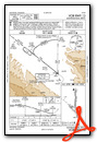
Instrument Approach Procedure (IAP) Charts
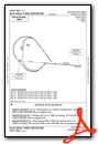
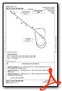
Departure Procedure (DP) Charts
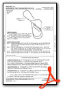
Departure Procedure Obstacles (DPO) Charts
Nearby Airports with Instrument Procedures
| ID | Name | Heading / Distance | ||
|---|---|---|---|---|
 |
KAJZ | Blake Field Airport | 334° | 18.3 |
|
KTEX | Telluride Regional Airport | 181° | 33.3 |
|
KAIB | Hopkins Field Airport | 242° | 35.5 |
|
KGUC | Gunnison-Crested Butte Regional Airport | 087° | 45.3 |
|
KGJT | Grand Junction Regional Airport | 321° | 47.2 |
|
KRIL | Rifle Garfield County Airport | 007° | 61.4 |
|
KASE | Aspen-Pitkin County/Sardy Field Airport | 048° | 64.3 |
|
U64 | Monticello Airport | 243° | 76.7 |
|
KCEZ | Cortez Municipal Airport | 205° | 80.3 |
|
KDRO | Durango-La Plata County Airport | 175° | 81.7 |
|
KEGE | Eagle County Regional Airport | 033° | 81.9 |
|
KPSO | Stevens Field Airport | 151° | 83.4 |
Airport Images
Do you have a recent image of this airport? Upload it here!


