Login
Register


MUT
Muscatine Municipal Airport
Official FAA Data Effective 2025-12-25 0901Z
Chart Supplement

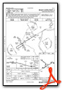
VFR Chart of KMUT
Sectional Charts at SkyVector.com
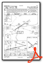
IFR Chart of KMUT
Enroute Charts at SkyVector.com
Location Information for KMUT
Coordinates: N41°22.07' / W91°8.89'Located 05 miles SW of Muscatine, Iowa on 604 acres of land. View all Airports in Iowa.
Surveyed Elevation is 547 feet MSL.
Operations Data
|
|
Airport Communications
| AWOS-3P: | 120.625 Tel. 563-263-0902 |
|---|---|
| QUAD CITY APPROACH: | 133.275 257.8 |
| QUAD CITY DEPARTURE: | 133.275 257.8 |
| CLEARANCE DELIVERY: | 119.125 |
| UNICOM: | 122.700 |
| CTAF: | 122.700 |
| ASOS at IOW (24.2 NW): | 128.075 319-339-9491 |
| AWOS-3 at AWG (24.3 W): | 127.825 319-653-4149 |
| ASOS at DVN (29.1 NE): | 120.175 563-388-2154 |
- APCH/DEP SVC PRVDD BY CHICAGO ARTCC ON FREQS 118.75/377.05 (MOLINE RCAG) WHEN QUAD CITY APCH CLSD.
Nearby Navigation Aids
|
| ||||||||||||||||||||||||||||||||||||||||||||||||||||||


Runway 06/24
| Dimensions: | 5500 x 100 feet / 1676 x 30 meters | |
|---|---|---|
| Surface: | Concrete / Grooved in Good Condition | |
| Weight Limits: | 20 /R/C/W/T, S-58, D-73 | |
| Edge Lighting: | Medium Intensity | |
| Runway 06 | Runway 24 | |
| Coordinates: | N41°21.74' / W91°9.27' | N41°22.21' / W91°8.24' |
| Elevation: | 544.7 | 541.4 |
| Traffic Pattern: | Left | Left |
| Runway Heading: | 58° True | 239° True |
| Markings: | Non-Precision Instrument in fair condition. | Precision Instrument in fair condition. |
| Glide Slope Indicator | V4L (3.00° Glide Path Angle) | P4R (3.00° Glide Path Angle) |
| Approach Lights: | MALSR 1,400 Foot Medium-intensity Approach Lighting System with runway alignment indicator lights. | |
| REIL: | Yes | |
| Obstacles: | 77 ft Tree 2097 ft from runway, 102 ft left of center | |
Runway 12/30
| Dimensions: | 4000 x 75 feet / 1219 x 23 meters | |
|---|---|---|
| Surface: | Concrete / Grooved in Good Condition | |
| Weight Limits: | 9 /R/C/W/T, S-28, D-39 | |
| Edge Lighting: | Medium Intensity | |
| Runway 12 | Runway 30 | |
| Coordinates: | N41°22.40' / W91°9.44' | N41°22.02' / W91°8.73' |
| Elevation: | 535.8 | 543.1 |
| Runway Heading: | 125° True | 305° True |
| Markings: | Non-Precision Instrument in fair condition. | Non-Precision Instrument in fair condition. |
| Glide Slope Indicator | P2L (3.25° Glide Path Angle) | P2L (3.00° Glide Path Angle) |
| REIL: | Yes | Yes |
| Obstacles: | 8 ft Tree 353 ft from runway, 13 ft right of center | |
Services Available
| Fuel: | 100LL (blue), Jet-A |
|---|---|
| Transient Storage: | Hangars,Tiedowns |
| Airframe Repair: | MINOR |
| Engine Repair: | MINOR |
| Bottled Oxygen: | NONE |
| Bulk Oxygen: | NONE |
| Other Services: | CHARTER SERVICE,PILOT INSTRUCTION,AIRCRAFT RENTAL,AIRCRAFT SALES |
Ownership Information
| Ownership: | Publicly owned | |
|---|---|---|
| Owner: | CITY OF MUSCATINE | |
| 215 SYCAMORE | ||
| MUSCATINE, IA 52761 | ||
| 563-264-1550 | ||
| Manager: | MIKE WOERLY | |
| 5701 SOUTH HIGHWAY 61 | ||
| MUSCATINE, IA 52761 | ||
| 563-263-8672 | ||
Other Remarks
- THIS AIRPORT HAS BEEN SURVEYED BY THE NATIONAL GEODETIC SURVEY.
- GLIDER OPN ON ARPT.
- FOR CD CTC CHICAGO ARTCC AT 630-906-8921.
- MIRL RYS 06/24 & 12/30 PRESET ON LOW INTST; TO INCR INTST & ACTVT VASI RY 06; MALSR RY 24; PAPI RYS 24, 12 & 30; REIL RYS 06; 12 & 30 - CTAF.
Weather Minimums
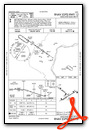
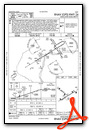
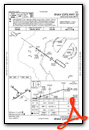
Instrument Approach Procedure (IAP) Charts
Nearby Airports with Instrument Procedures
| ID | Name | Heading / Distance | ||
|---|---|---|---|---|
 |
8C4 | Mathews Memorial Airport | 359° | 23.7 |
|
KIOW | Iowa City Municipal Airport | 312° | 24.3 |
|
KAWG | Washington Municipal Airport | 257° | 24.5 |
|
KDVN | Davenport Municipal Airport | 059° | 29.1 |
|
KMLI | Quad Cities International Airport | 080° | 29.3 |
|
KMPZ | Mount Pleasant Municipal Airport | 213° | 30.1 |
|
KBRL | Southeast Iowa Regional Airport | 178° | 35.1 |
|
C66 | Monmouth Municipal Airport | 138° | 35.2 |
|
KCID | The Eastern Iowa Airport | 320° | 40.0 |
|
KGBG | Harrel W Timmons Galesburg Regional Airport | 128° | 41.5 |
|
KFFL | Fairfield Municipal Airport | 243° | 42.1 |
|
C17 | Marion Airport | 336° | 43.3 |
Airport Images
Do you have a recent image of this airport? Upload it here!


