Login
Register


MZZ
Marion Municipal - Mckinney Field Airport
Official FAA Data Effective 2025-11-27 0901Z
Chart Supplement

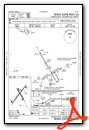
VFR Chart of KMZZ
Sectional Charts at SkyVector.com
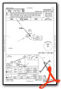
IFR Chart of KMZZ
Enroute Charts at SkyVector.com
Location Information for KMZZ
Coordinates: N40°29.40' / W85°40.79'Located 03 miles SW of Marion, Indiana on 506 acres of land. View all Airports in Indiana.
Surveyed Elevation is 858 feet MSL.
Operations Data
|
|
Airport Communications
| AWOS-3: | 108.6 Tel. 765-674-1317 |
|---|---|
| GRISSOM APPROACH: | 121.05 338.275 |
| GRISSOM DEPARTURE: | 121.05 338.275 |
| CLEARANCE DELIVERY: | 120.0 |
| CTAF: | 122.700 |
| UNICOM: | 122.700 |
| AWOS-3PT at OKK (17.3 W): | 128.675 765-452-3014 |
| ASOS at MIE (19.7 SE): | 114.4 765-288-9617 |
| ATIS at MIE (19.7 SE): | 133.25 |
- APCH/DEP SVC PRVDD BY CHICAGO ARTCC ON FREQS 121.05 (REMOTED FROM GRISSOM) WHEN GRISSOM APCH CTL CLSD.
Nearby Navigation Aids
|
| ||||||||||||||||||||||||||||||||||||||||||||||||||||||||||||


Runway 04/22
| Dimensions: | 6011 x 100 feet / 1832 x 30 meters | |
|---|---|---|
| Surface: | Asphalt / Grooved in Good Condition | |
| Weight Limits: | 28 /F/C/Y/T, S-60, D-90, ST-70 | |
| Edge Lighting: | High Intensity | |
| Runway 04 | Runway 22 | |
| Coordinates: | N40°29.01' / W85°41.22' | N40°29.79' / W85°40.43' |
| Elevation: | 858.1 | 850.0 |
| Traffic Pattern: | Left | Left |
| Runway Heading: | 37° True | 217° True |
| Markings: | Precision Instrument in good condition. | Non-Precision Instrument in good condition. |
| Glide Slope Indicator | P4L (3.00° Glide Path Angle) | |
| Approach Lights: | MALSR 1,400 Foot Medium-intensity Approach Lighting System with runway alignment indicator lights. | |
| REIL: | Yes | |
Runway 15/33
| Dimensions: | 3456 x 100 feet / 1053 x 30 meters | |
|---|---|---|
| Surface: | Asphalt / Grooved in Good Condition | |
| Weight Limits: | S-22, D-32 | |
| Edge Lighting: | Medium Intensity | |
| Runway 15 | Runway 33 | |
| Coordinates: | N40°29.64' / W85°40.91' | N40°29.14' / W85°40.54' |
| Elevation: | 857.5 | 849.5 |
| Traffic Pattern: | Left | Left |
| Runway Heading: | 150° True | 330° True |
| Markings: | Basic in good condition. | Basic in good condition. |
| Glide Slope Indicator | P2L (3.25° Glide Path Angle) | P2L (4.00° Glide Path Angle) PAPI UNUSBL BYD 9 DEGS LEFT OF CNTRLN. |
| REIL: | Yes | Yes |
| Obstacles: | 15 ft Tree 400 ft from runway, 120 ft left of center | 10 ft Trees 300 ft from runway, 190 ft left of center |
Services Available
| Fuel: | 100LL (blue), Jet-A |
|---|---|
| Transient Storage: | Hangars,Tiedowns |
| Airframe Repair: | MAJOR |
| Engine Repair: | MAJOR |
| Bottled Oxygen: | LOW |
| Bulk Oxygen: | LOW |
| Other Services: | PILOT INSTRUCTION,AIRCRAFT RENTAL |
Ownership Information
| Ownership: | Publicly owned | |
|---|---|---|
| Owner: | CITY OF MARION BOAC | |
| 5904 S WESTERN AVE | ||
| MARION, IN 46953 | ||
| 765-674-7777 | ||
| Manager: | ANDY DARLINGTON | |
| 5904 S WESTERN AVE | ||
| MARION, IN 46953 | ||
| 765-674-7777 | ||
Other Remarks
- FOR CD CTC CHICAGO ARTCC AT 630-906-8921.
- -12 FT DITCH 200 FT L OF CNTRLN; 8 - 10 FT GND 230 FT L OF CNTRLN PARL S HALF OF RWY.
- 0LL SELF SVC AVBL.
- ACTVT MALSR RWY 04; REIL RWY 15, 22 & 33; PAPI RWY 22- CTAF. PAPI RWY 15 & 33 ON DURG DAY; ACTVT AT NIGHT- CTAF. HIRL RWY 04/22; MIRL RWY 15/33 PRESET LOW INTST; INCR INTST - CTAF.
Weather Minimums

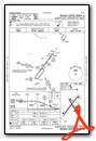
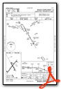
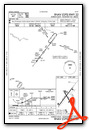
Instrument Approach Procedure (IAP) Charts

Nearby Airports with Instrument Procedures
| ID | Name | Heading / Distance | ||
|---|---|---|---|---|
 |
KIWH | Wabash Municipal Airport | 341° | 17.2 |
|
KOKK | Kokomo Municipal Airport | 277° | 17.5 |
|
KMIE | Delaware County Regional Airport | 138° | 19.7 |
|
KAID | Anderson Regional Airport | 172° | 23.1 |
|
KGUS | Grissom Arb Airport | 293° | 23.6 |
|
KHHG | Huntington Municipal Airport | 024° | 24.0 |
|
I76 | Peru Municipal Airport | 309° | 27.7 |
|
5I4 | Sheridan Airport | 233° | 30.9 |
|
KPLD | Portland Municipal Airport | 093° | 31.6 |
|
KGGP | Logansport/Cass County Airport | 292° | 34.3 |
|
KFWA | Fort Wayne International Airport | 036° | 36.7 |
|
KUMP | Indianapolis Metro Airport | 206° | 37.2 |
Airport Images

By: doublee3


