Login
Register
NM03
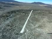
Grant Besley Airport
Official FAA Data Effective 2026-01-22 0901Z
VFR Chart of NM03
Sectional Charts at SkyVector.com
IFR Chart of NM03
Enroute Charts at SkyVector.com
Location Information for NM03
Coordinates: N36°39.73' / W105°43.21'Located 19 miles NW of Taos, New Mexico. View all Airports in New Mexico.
Estimated Elevation is 7646 feet MSL.
Operations Data
|
|
Airport Communications
| AWOS-3PT at N24 (10.2 NE): | 118.2 575-586-2019 |
|---|---|
| AWOS-3PT at SKX (12.4 S): | 132.975 575-758-5663 |
| AWOS-3 at AXX (25.3 SE): | 118.025 575-377-0526 |
Nearby Navigation Aids
|
| ||||||||||||||||||||||||||||||
Runway 18/36
| Dimensions: | 4500 x 50 feet / 1372 x 15 meters | |
|---|---|---|
| Surface: | Gravel | |
| Runway 18 | Runway 36 | |
Ownership Information
| Ownership: | Privately Owned | |
|---|---|---|
| Owner: | FLYING W RANCH, LLC | |
| 7631 CENTER BAY DRIVE | ||
| NORTH BAY VILLAGE, FL 33141 | ||
| 786-210-8684 | ||
| Manager: | S.M. WEISS | |
| 7631 CENTER BAY DRIVE | ||
| NORTH BAY VILLAGE, FL 33141 | ||
| 786-210-8684 | ||
Other Remarks
- MONITOR 122.9 IN VICINITY OF AIRPORT.
- LINE OF SIGHT NON-EXISTENT BETWEEN RUNWAY ENDS.
- FOR CD CTC ALBUQUERQUE ARTCC AT 505-856-4861.
Nearby Airports with Instrument Procedures
| ID | Name | Heading / Distance | ||
|---|---|---|---|---|
 |
KSKX | Taos Regional Airport | 169° | 12.8 |
 |
KAXX | Angel Fire Airport | 124° | 25.3 |
 |
KALS | San Luis Valley Regional/Bergman Field Airport | 351° | 46.9 |
 |
KLAM | Los Alamos Airport | 209° | 53.9 |
 |
KMVI | Monte Vista Municipal Airport | 343° | 54.2 |
 |
KRTN | Raton Municipal/Crews Field Airport | 084° | 59.0 |
 |
KSAF | Santa Fe Regional Airport | 196° | 65.1 |
 |
KLVS | Las Vegas Municipal Airport | 154° | 66.6 |
 |
KRCV | Astronaut Kent Rominger Airport | 334° | 69.9 |
 |
KPSO | Stevens Field Airport | 300° | 74.3 |
 |
KTAD | Perry Stokes Airport | 061° | 75.4 |
 |
4V1 | Spanish Peaks Airfield Airport | 035° | 76.5 |


