Login
Register


ONL
The O'Neill Municipal-John L Baker Field Airport
Official FAA Data Effective 2025-12-25 0901Z
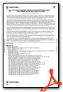
Chart Supplement

VFR Chart of KONL
Sectional Charts at SkyVector.com
IFR Chart of KONL
Enroute Charts at SkyVector.com
Location Information for KONL
Coordinates: N42°28.16' / W98°41.27'Located 02 miles NW of O'Neill, Nebraska on 316 acres of land. View all Airports in Nebraska.
Surveyed Elevation is 2033 feet MSL.
Operations Data
|
|
Airport Communications
| AWOS-3: | 121.125 Tel. 402-336-4834 |
|---|---|
| CTAF: | 122.800 |
| UNICOM: | 122.800 |
| AWOS-3PT at 4V9 (35.9 SE): | 119.275 402-887-5233 |
| AWOS-3P at AGZ (39.7 NE): | 128.325 605-384-3922 |
| ASOS at ODX (52.1 S): | 119.925 308-728-7954 |
- APCH/DEP SVC PRVDD BY MINNEAPOLIS ARTCC ON FREQS 128.0/257.95 (O'NEILL RCAG).
Nearby Navigation Aids
|
| ||||||||||||||||||||||||||||||||||||||||||||||||||||||


Runway 13/31
| Dimensions: | 4408 x 75 feet / 1344 x 23 meters | |
|---|---|---|
| Surface: | Concrete in Excellent Condition | |
| Weight Limits: | S-30 | |
| Edge Lighting: | Medium Intensity | |
| Runway 13 | Runway 31 | |
| Coordinates: | N42°28.47' / W98°41.61' | N42°27.92' / W98°40.96' |
| Elevation: | 2032.0 | 2031.7 |
| Traffic Pattern: | Left | Left |
| Runway Heading: | 139° True | 319° True |
| Markings: | Non-Precision Instrument in good condition. | Non-Precision Instrument in good condition. |
| Glide Slope Indicator | P2L (3.00° Glide Path Angle) | P2L (3.00° Glide Path Angle) |
| REIL: | Yes | Yes |
Runway 04/22
| Dimensions: | 3200 x 60 feet / 975 x 18 meters | |
|---|---|---|
| Surface: | Concrete | |
| Runway 04 | Runway 22 | |
| Coordinates: | N42°27.94' / W98°41.51' | N42°28.29' / W98°40.98' |
| Elevation: | 2033.5 | 2029.2 |
| Runway Heading: | 48° True | 228° True |
| Markings: | Non-Precision Instrument in good condition. | Non-Precision Instrument in good condition. |
Services Available
| Fuel: | 100LL (blue), Jet A+ |
|---|---|
| Transient Storage: | Hangars,Tiedowns |
| Airframe Repair: | MAJOR |
| Engine Repair: | MAJOR |
| Bottled Oxygen: | NONE |
| Bulk Oxygen: | NONE |
| Other Services: | CROP DUSTING SERVICES,PILOT INSTRUCTION,AIRCRAFT RENTAL |
Ownership Information
| Ownership: | Publicly owned | |
|---|---|---|
| Owner: | O'NEILL AIRPORT AUTHORITY | BARTON BECKER, CHAIRMAN OF ARPT AUTHORITY. |
| 87204 JOHN L. BAKER ROAD | ||
| O'NEILL, NE 68763-4614 | ||
| (402) 336-3377 | ||
| Manager: | CORY JOHNSON | |
| 87204 JOHN L BAKER ROAD | ||
| O'NEILL, NE 68763-4614 | ||
| 402-760-1232 | ||
Other Remarks
- WATCH FOR LRG FLOCKS OF WATERFOWL DRG MIGRATION SEASONS (FEBRUARY AND OCTOBER)
- FOR CD IF UNA TO CTC ON FSS FREQ, CTC MINNEAPOLIS ARTCC AT 651-463-5588.
- ACTVT REIL RWYS 13 & 31; PAPI RWYS 13 & 31; MIRL RWY 13/31 - CTAF.
Weather Minimums
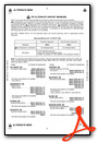
Instrument Approach Procedure (IAP) Charts


Nearby Airports with Instrument Procedures
| ID | Name | Heading / Distance | ||
|---|---|---|---|---|
 |
8V2 | Stuart-Atkinson Municipal Airport | 289° | 16.6 |
|
6K3 | Creighton Municipal Airport | 089° | 35.7 |
|
4V9 | Antelope County Airport | 126° | 35.9 |
|
KRBE | Rock County Airport | 279° | 39.6 |
|
KAGZ | Wagner Municipal Airport | 025° | 39.7 |
|
KBUB | Cram Field Airport | 206° | 46.3 |
|
KODX | Evelyn Sharp Field Airport | 193° | 52.1 |
|
KBVN | Albion Municipal Airport | 147° | 52.6 |
|
9D1 | Gregory Municipal/Flynn Field Airport | 325° | 55.1 |
|
KANW | Ainsworth Regional Airport | 276° | 58.3 |
|
8V3 | Parkston Municipal Airport | 029° | 62.6 |
|
KOFK | Norfolk Regional/Karl Stefan Memorial Field Airport | 117° | 62.9 |
Airport Images
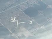
By: Big Orange Bird


