Login
Register


PSB
Mid-State Airport
Official FAA Data Effective 2024-04-18 0901Z
Chart Supplement

VFR Chart of KPSB
Sectional Charts at SkyVector.com
IFR Chart of KPSB
Enroute Charts at SkyVector.com
Location Information for KPSB
Coordinates: N40°53.06' / W78°5.24'Located 08 miles E of Philipsburg, Pennsylvania on 487 acres of land. View all Airports in Pennsylvania.
Surveyed Elevation is 1948 feet MSL.
Operations Data
|
|
Airport Communications
| AWOS-3: | 127.525 Tel. 814-343-4531 |
|---|---|
| CTAF: | 122.900 |
| AWOS-3 at UNV (11.0 E): | 127.65 814-865-8799 |
| D-ATIS at UNV (11.1 E): | 127.65 |
| ASOS at FLF (11.8 SE): | 814-237-5778 |
- APCH/DEP SVC PRVDD BY NEW YORK ARTCC ON FREQS 134.8/338.3 (PHILIPSBURG RCAG).
Nearby Navigation Aids
|
| ||||||||||||||||||||||||||||||||||||||||||||||||||||||


Runway 16/34
| Dimensions: | 5711 x 100 feet / 1741 x 30 meters | |
|---|---|---|
| Surface: | Asphalt in Poor Condition ASPH CRUMBLING AT INTXN OF RWYS CAUSING POTHOLES AND FOD. | |
| Weight Limits: | S-48, D-60, ST-90 | |
| Edge Lighting: | Medium Intensity | |
| Runway 16 | Runway 34 | |
| Coordinates: | N40°53.60' / W78°5.49' | N40°52.74' / W78°4.99' |
| Elevation: | 1947.8 | 1921.5 |
| Traffic Pattern: | Left | Left |
| Runway Heading: | 156° True | 336° True |
| Markings: | Precision Instrument in poor condition. | Precision Instrument in poor condition. |
| Obstacles: | 23 ft Brush 315 ft from runway, 263 ft right of center | 39 ft Trees 549 ft from runway, 237 ft left of center |
Runway 06/24
| Dimensions: | 5006 x 100 feet / 1526 x 30 meters | |
|---|---|---|
| Surface: | Asphalt in Poor Condition ASPH CRUMBLING AT INTXN OF RWYS CAUSING POTHOLES AND FOD. | |
| Weight Limits: | S-48, D-60, ST-90 | |
| Edge Lighting: | Medium Intensity | |
| Runway 06 | Runway 24 | |
| Coordinates: | N40°52.67' / W78°5.66' | N40°53.20' / W78°4.83' |
| Elevation: | 1866.9 | 1916.8 |
| Traffic Pattern: | Left | Left |
| Runway Heading: | 50° True | 230° True |
| Markings: | Non-Precision Instrument in poor condition. | Non-Precision Instrument in poor condition. |
| Obstacles: | 16 ft Trees 353 ft from runway, 81 ft left of center RWY 24 CLOSED FOR NGT VISUAL APCH DUE TO OBSTNS. |
35 ft Trees 328 ft from runway, 173 ft left of center |
Services Available
| Fuel: | NONE |
|---|---|
| Transient Storage: | Tiedowns |
| Airframe Repair: | NONE |
| Engine Repair: | NONE |
| Bottled Oxygen: | NONE |
| Bulk Oxygen: | NONE |
Ownership Information
| Ownership: | Publicly owned | |
|---|---|---|
| Owner: | MID STATE REG ARPT AUTH | |
| 451 AIRPORT ROAD | ||
| PHILIPSBURG, PA 16866 | ||
| 814-342-6296 | ||
| Manager: | DAVE PRYDE | |
| 451 AIRPORT ROAD | ||
| PHILIPSBURG, PA 16866 | ||
| 814-342-1080 | ||
Operational Statistics
| Single Engine Aircraft Based on Field: | 2 | Statistics collected for 12 month period ending 2023-05-16 | |
|---|---|---|---|
| Multi-Engine Aircraft Based on Field: | 1 | Annual Commercial Operations: | none |
| Jet Aircraft Based on Field: | none | Annual Commuter Operations: | none |
| Helicopters Based on Field: | none | Annual Air Taxi Operations: | none |
| Military Aircraft Based on Field: | none | Annual Military Operations: | 300 |
| Gliders Based on Field: | 9 | Annual GA Local Operations: | 700 |
| Ultralights Based on Field: | none | Annual GA Itinerant Operations: | 500 |
Other Remarks
- THIS AIRPORT HAS BEEN SURVEYED BY THE NATIONAL GEODETIC SURVEY.
- DEER ON & INVOF ARPT.
- HEAVY GLIDER ACTIVITY DURING DALGT HRS, ALL ALTS, ON AND INVOF AIRPORT AND WITHIN 15 NM EAST AND SOUTH OF ARPT.
- CTC NG OPS 30.5/122.85/242.4
- FOR CD IF UNA TO CTC ON FSS FREQ, CTC NEW YORK ARTCC AT 631-468-1425.
- ARPT ACES LTD; CTC MGR TO COORD 814-342-1080.
- MARKINGS EXTREMELY FADED.
- MARKINGS EXTREMELY FADED.
- MARKINGS EXTREMELY FADED.
- MRKGS EXTRMLY FADED.
- ACTVT MIRL RWY 06/24 & 16/34 - CTAF.
Weather Minimums
Instrument Approach Procedure (IAP) Charts
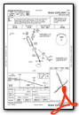
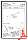
Nearby Airports with Instrument Procedures
| ID | Name | Heading / Distance | ||
|---|---|---|---|---|
 |
KUNV | State College Regional Airport | 100° | 11.1 |
|
N96 | Bellefonte Airport | 089° | 12.3 |
|
KFIG | Clearfield-Lawrence Airport | 303° | 17.9 |
|
KRVL | Mifflin County Airport | 120° | 24.4 |
|
KLHV | William T Piper Memorial Airport | 063° | 33.8 |
|
P34 | Mifflintown Airport | 118° | 35.5 |
|
KOYM | St Marys Municipal Airport | 329° | 36.8 |
|
KAOO | Altoona/Blair County Airport | 196° | 36.8 |
|
N35 | Punxsutawney Municipal Airport | 277° | 38.6 |
|
9G8 | Ebensburg Airport | 231° | 40.4 |
|
KDUJ | Dubois Regional Airport | 295° | 40.8 |
|
KJST | John Murtha Johnstown/Cambria County Airport | 225° | 48.3 |
Airport Images

By: N714AJ

By: N714AJ


