Login
Register


RYV
Watertown Municipal Airport
Official FAA Data Effective 2024-04-18 0901Z
Chart Supplement

VFR Chart of KRYV
Sectional Charts at SkyVector.com
IFR Chart of KRYV
Enroute Charts at SkyVector.com
Location Information for KRYV
Coordinates: N43°10.18' / W88°43.39'Located 00 miles S of Watertown, Wisconsin on 360 acres of land. View all Airports in Wisconsin.
Surveyed Elevation is 832 feet MSL.
Operations Data
|
|
Airport Communications
| AWOS-3: | 119.975 Tel. 920-261-0734 |
|---|---|
| MADISON APPROACH: | 119.15 343.7 |
| MADISON DEPARTURE: | 119.15 343.7 |
| CTAF: | 122.800 |
| UNICOM: | 122.800 |
| AWOS-3 at UNU (15.4 N): | 120.825 920-386-5682 |
| ATIS at UES (22.7 E): | 118.875 |
| AWOS-3 at UES (22.7 E): | 118.875 262-521-5226 |
- APCH/DEP SVC PRVDD BY CHICAGO ARTCC ON FREQS 133.3/257.925 (LONE ROCK RCAG) WHEN MADISON APCH CTL CLSD.
Nearby Navigation Aids
|
| ||||||||||||||||||||||||||||||||||||||||||||||||||||||


Runway 05/23
| Dimensions: | 4429 x 75 feet / 1350 x 23 meters | |
|---|---|---|
| Surface: | Asphalt in Fair Condition | |
| Weight Limits: | S-30, D-60 | |
| Edge Lighting: | Medium Intensity | |
| Runway 05 | Runway 23 | |
| Coordinates: | N43°9.91' / W88°43.85' | N43°10.35' / W88°43.05' |
| Elevation: | 817.4 | 822.9 |
| Traffic Pattern: | Right | Left |
| Runway Heading: | 53° True | 233° True |
| Displaced Threshold: | 190 Feet | |
| Declared Distances: | TORA:4430 TODA:5110 ASDA:4550 LDA:4430 | TORA:4430 TODA:4845 ASDA:4430 LDA:4430 |
| Markings: | Non-Precision Instrument in fair condition. | Non-Precision Instrument in fair condition. |
| Glide Slope Indicator | P2L (3.00° Glide Path Angle) | P2L (3.00° Glide Path Angle) |
| REIL: | Yes | Yes |
| Obstacles: | 40 ft Tree 950 ft from runway, 15 ft right of center APCH RATIO 23:1 TO DSPLCD THR. |
76 ft Tree 1450 ft from runway, 400 ft right of center |
Runway 11/29
| Dimensions: | 2801 x 75 feet / 854 x 23 meters | |
|---|---|---|
| Surface: | Asphalt in Fair Condition | |
| Weight Limits: | S-30 | |
| Edge Lighting: | Medium Intensity | |
| Runway 11 | Runway 29 | |
| Coordinates: | N43°10.34' / W88°43.60' | N43°10.17' / W88°43.01' |
| Elevation: | 822.8 | 832.9 |
| Traffic Pattern: | Right | |
| Runway Heading: | 112° True | 292° True |
| Markings: | Non-Precision Instrument in fair condition. | Non-Precision Instrument in fair condition. |
| Obstacles: | 42 ft Trees 900 ft from runway, 225 ft left of center | 64 ft Tree 1100 ft from runway, 350 ft right of center |
Services Available
| Fuel: | 100LL (blue), Jet-A |
|---|---|
| Transient Storage: | Hangars,Tiedowns |
| Airframe Repair: | MAJOR |
| Engine Repair: | MAJOR |
| Bottled Oxygen: | NOT AVAILABLE |
| Bulk Oxygen: | LOW |
| Other Services: | CHARTER SERVICE,PILOT INSTRUCTION,AIRCRAFT RENTAL,AIRCRAFT SALES |
Ownership Information
| Ownership: | Publicly owned | |
|---|---|---|
| Owner: | CITY OF WATERTOWN | |
| 106 JONES | ||
| WATERTOWN, WI 53094 | ||
| 920-262-4000 | ||
| Manager: | JEFF BAUM | |
| 1741 RIVER DRIVE | ||
| WATERTOWN, WI 53094 | ||
| 920-261-4567 | ||
Operational Statistics
| Single Engine Aircraft Based on Field: | 51 | Statistics collected for 12 month period ending 2021-05-24 | |
|---|---|---|---|
| Multi-Engine Aircraft Based on Field: | 7 | Annual Commercial Operations: | none |
| Jet Aircraft Based on Field: | 2 | Annual Commuter Operations: | none |
| Helicopters Based on Field: | none | Annual Air Taxi Operations: | 5500 |
| Military Aircraft Based on Field: | none | Annual Military Operations: | 1000 |
| Gliders Based on Field: | none | Annual GA Local Operations: | 35000 |
| Ultralights Based on Field: | none | Annual GA Itinerant Operations: | 16500 |
Other Remarks
- THIS AIRPORT HAS BEEN SURVEYED BY THE NATIONAL GEODETIC SURVEY.
- DEER ON & INVOF ARPT.
- DUCKS & SEAGULLS OCCASSIONALLY NEAR ARPT DURING SEASONAL MIGRATIONS.
- FOR CD CTC MADISON APP/DEP CON AT 608-249-8240. WHEN MADISON APCH CLSD, FOR CD CTC CHICAGO ARTCC AT 630-906-8921.
- ACTVT MIRL RYS 05/23 & 11/29, PAPI RYS 05 & 23 & REIL RYS 05 & 23 - CTAF.
Weather Minimums
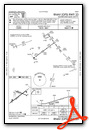
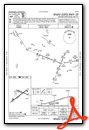
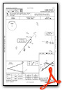
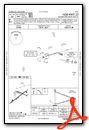
Instrument Approach Procedure (IAP) Charts
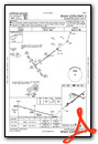
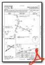
Nearby Airports with Instrument Procedures
| ID | Name | Heading / Distance | ||
|---|---|---|---|---|
 |
61C | Fort Atkinson Municipal Airport | 198° | 13.1 |
|
KUNU | Dodge County Airport | 003° | 15.4 |
|
KHXF | Hartford Municipal Airport | 053° | 18.2 |
|
87Y | Blackhawk Airfield Airport | 259° | 20.7 |
|
KUES | Waukesha County Airport | 109° | 22.7 |
|
KMSN | Dane County Regional/Truax Field Airport | 266° | 27.0 |
|
57C | East Troy Municipal Airport | 145° | 27.2 |
|
KETB | West Bend Municipal Airport | 059° | 30.2 |
|
KMWC | Lawrence J Timmerman Airport | 096° | 30.5 |
|
KBUU | Burlington Municipal Airport | 147° | 34.1 |
|
C29 | Middleton Municipal/Morey Field Airport | 264° | 35.7 |
|
KJVL | Southern Wisconsin Regional Airport | 203° | 35.8 |
Airport Images
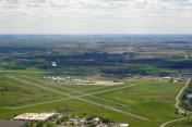
By: Shalinij


