Login
Register


JVL
Southern Wisconsin Regional Airport
Official FAA Data Effective 2024-05-16 0901Z
Chart Supplement

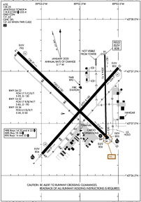
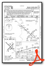
KJVL Airport Diagram
VFR Chart of KJVL
Sectional Charts at SkyVector.com
IFR Chart of KJVL
Enroute Charts at SkyVector.com
Location Information for KJVL
Coordinates: N42°37.22' / W89°2.49'Located 03 miles SW of Janesville, Wisconsin on 1343 acres of land. View all Airports in Wisconsin.
Surveyed Elevation is 807 feet MSL.
Operations Data
|
|
Airport Communications
| ATIS: | 128.25 |
|---|---|
| AWOS-3: | Tel. 608-758-1723 |
| JANESVILLE TOWER: | 118.8 225.4 |
| JANESVILLE GROUND: | 121.65 |
| ROCKFORD APPROACH: | 121.0 327.0 |
| ROCKFORD DEPARTURE: | 121.0 327.0 |
| CLEARANCE DELIVERY: | 121.65 121.65 ;WHEN TWR CLSD |
| CTAF: | 118.800 |
| UNICOM: | 122.950 |
| EMERG: | 121.5 243.0 |
| AWOS-3 at EFT (24.3 W): | 118.375 608-328-8359 |
| ASOS at RFD (25.6 S): | 815-484-6223 |
| ATIS at RFD (25.6 S): | 127.6 |
Nearby Navigation Aids
|
| ||||||||||||||||||||||||||||||||||||||||||||||||


Runway 14/32
| Dimensions: | 7302 x 150 feet / 2226 x 46 meters | |
|---|---|---|
| Surface: | Concrete / Grooved in Fair Condition | |
| Weight Limits: | 17 /R/B/W/T, S-85, D-190 | |
| Edge Lighting: | High Intensity | |
| Runway 14 | Runway 32 | |
| Coordinates: | N42°37.69' / W89°3.31' | N42°36.86' / W89°2.13' |
| Elevation: | 795.1 | 805.4 |
| Traffic Pattern: | Left | Left |
| Runway Heading: | 134° True | 314° True |
| Declared Distances: | TORA:7302 TODA:7302 ASDA:7302 LDA:7302 | TORA:7302 TODA:7302 ASDA:7302 LDA:7302 |
| Markings: | Precision Instrument in fair condition. | Precision Instrument in good condition. |
| Glide Slope Indicator | P4L (3.00° Glide Path Angle) | V4L (3.00° Glide Path Angle) |
| Approach Lights: | MALSR 1,400 Foot Medium-intensity Approach Lighting System with runway alignment indicator lights. | |
| REIL: | Yes | |
Runway 04/22
| Dimensions: | 6701 x 150 feet / 2042 x 46 meters | |
|---|---|---|
| Surface: | Asphalt / Grooved in Fair Condition | |
| Weight Limits: | 17 /F/C/X/T, S-95, D-130
APRONS & RAMPS RSTD TO 155 DTW GROSS WT.
| |
| Edge Lighting: | High Intensity | |
| Runway 04 | Runway 22 | |
| Coordinates: | N42°36.71' / W89°2.99' | N42°37.53' / W89°2.00' |
| Elevation: | 803.7 | 804.8 |
| Traffic Pattern: | Left | Left |
| Runway Heading: | 42° True | 222° True |
| Declared Distances: | TORA:6701 TODA:6701 ASDA:6701 LDA:6701 | TORA:6701 TODA:6701 ASDA:6701 LDA:6701 |
| Markings: | Precision Instrument in good condition. | Precision Instrument in good condition. |
| Glide Slope Indicator | P4L (3.00° Glide Path Angle) | P4L (3.00° Glide Path Angle) |
| Approach Lights: | MALSR 1,400 Foot Medium-intensity Approach Lighting System with runway alignment indicator lights. | |
| REIL: | Yes | |
| Obstacles: | 83 ft Tree 2792 ft from runway, 367 ft right of center | |
Runway 18/36
RWY 18/36 NOT AVBL FOR UNSKED ACR AT LEAST 31 PASGR SEATS. | ||
| Dimensions: | 5004 x 75 feet / 1525 x 23 meters | |
|---|---|---|
| Surface: | Asphalt in Fair Condition | |
| Weight Limits: | 6 /F/B/X/T, S-40, D-50 | |
| Edge Lighting: | Medium Intensity | |
| Runway 18 | Runway 36 | |
| Coordinates: | N42°37.67' / W89°2.17' | N42°36.85' / W89°2.16' |
| Elevation: | 807.8 | 805.7 |
| Traffic Pattern: | Left | Left |
| Runway Heading: | 179° True | 359° True |
| Declared Distances: | TORA:5004 TODA:5004 ASDA:5004 LDA:5004 | TORA:5004 TODA:5004 ASDA:5004 LDA:5004 |
| Markings: | Basic in fair condition. | Basic in fair condition. |
| Obstacles: | 16 ft Road 385 ft from runway, 20 ft right of center | |
Services Available
| Fuel: | 100LL (blue), Jet-A |
|---|---|
| Transient Storage: | Hangars,Tiedowns |
| Airframe Repair: | MAJOR |
| Engine Repair: | MAJOR |
| Bottled Oxygen: | NOT AVAILABLE |
| Bulk Oxygen: | NOT AVAILABLE |
| Other Services: | AVIONICS,CHARTER SERVICE,PILOT INSTRUCTION,AIRCRAFT RENTAL |
Ownership Information
| Ownership: | Publicly owned | |
|---|---|---|
| Owner: | ROCK COUNTY | |
| 51 SOUTH MAIN ST | ||
| JANESVILLE, WI 53545 | ||
| 608-757-5768 | ||
| Manager: | GREG CULLEN | |
| 1716 W. AIRPORT RD | ||
| JANESVILLE, WI 53546 | ||
| 608-757-5768 | ||
Operational Statistics
| Single Engine Aircraft Based on Field: | 45 | Statistics collected for 12 month period ending 2021-12-31 | |
|---|---|---|---|
| Multi-Engine Aircraft Based on Field: | 5 | Annual Commercial Operations: | none |
| Jet Aircraft Based on Field: | 33 | Annual Commuter Operations: | none |
| Helicopters Based on Field: | 4 | Annual Air Taxi Operations: | 5571 |
| Military Aircraft Based on Field: | none | Annual Military Operations: | 214 |
| Gliders Based on Field: | none | Annual GA Local Operations: | 23984 |
| Ultralights Based on Field: | none | Annual GA Itinerant Operations: | 24975 |
Other Remarks
- LGT SPORT ACFT WITH CRUISE SPEED OF 60 MPH OR LESS ENTER TFC PAT AT 500 AGL.
- RWY 32 & 36 APCH ENDS CLOSELY ALIGNED; VERIFY CORRECT RWY AND COMPASS HEADING PRIOR TO DEP.
- ACTVT MALSR RWY 04 & 32; REIL RWY 14 & 22; VASI RWY 32; HIRL RWY 04/22 & 14/32; MIRL RWY 18/36 - CTAF. WHEN ATCT CLSD HIRL RWY 04/22 PRESET ON LOW INTST; INCR INTST - CTAF. PAPI RWY 04, 14, & 22 OPR CONSLY.
Weather Minimums
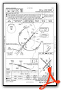
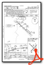
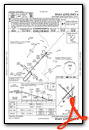
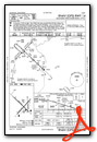
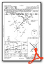
Instrument Approach Procedure (IAP) Charts
Nearby Airports with Instrument Procedures
| ID | Name | Heading / Distance | ||
|---|---|---|---|---|
 |
44C | Beloit Airport | 155° | 8.0 |
|
C77 | Poplar Grove Airport | 152° | 20.0 |
|
61C | Fort Atkinson Municipal Airport | 025° | 22.8 |
|
KEFT | Monroe Municipal Airport | 269° | 24.3 |
|
KRFD | Chicago/Rockford International Airport | 185° | 25.6 |
|
C02 | Grand Geneva Resort Airport | 090° | 28.9 |
|
87Y | Blackhawk Airfield Airport | 347° | 29.7 |
|
57C | East Troy Municipal Airport | 070° | 31.4 |
|
10C | Galt Field Airport | 113° | 32.3 |
|
KBUU | Burlington Municipal Airport | 082° | 32.9 |
|
KFEP | Albertus Airport | 227° | 32.9 |
|
KMSN | Dane County Regional/Truax Field Airport | 337° | 33.8 |
Fuel Providers

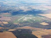
Airport Images

By: james_sm
By: skiwoods


