Login
Register


SEF
Sebring Regional Airport
Official FAA Data Effective 2024-04-18 0901Z
Chart Supplement

VFR Chart of KSEF
Sectional Charts at SkyVector.com
IFR Chart of KSEF
Enroute Charts at SkyVector.com
Location Information for KSEF
Coordinates: N27°27.38' / W81°20.54'Located 06 miles SE of Sebring, Florida on 1768 acres of land. View all Airports in Florida.
Surveyed Elevation is 61 feet MSL.
Operations Data
|
|
Airport Communications
| AWOS-3: | 119.475 Tel. 863-655-6424 |
|---|---|
| CTAF: | 122.700 |
| UNICOM: | 122.700 |
| AWOS-3 at AVO (12.9 NW): | 118.725 863-453-4223 |
| AWOS-3 at OBE (28.7 SE): | 118.675 863-467-1148 |
| AWOS-2 at CHN (29.0 W): | 118.35 863-767-0559 |
- APCH/DEP SVC PRVDD BY MIAMI ARTCC ON FREQS 134.55/257.7 (AVON PARK RCAG).
Nearby Navigation Aids
|
| ||||||||||||||||||||||||||||||||||||||||||||||||||||||


Runway 01/19
| Dimensions: | 5234 x 100 feet / 1595 x 30 meters | |
|---|---|---|
| Surface: | Asphalt in Good Condition | |
| Weight Limits: | 32 /F/A/X/T, S-26, D-50, ST-85 | |
| Edge Lighting: | Medium Intensity | |
| Runway 01 | Runway 19 | |
| Coordinates: | N27°26.89' / W81°20.58' | N27°27.76' / W81°20.58' |
| Elevation: | 55.9 | 58.5 |
| Traffic Pattern: | Left | Left |
| Runway Heading: | 360° True | 180° True |
| Markings: | Non-Precision Instrument in fair condition. | Non-Precision Instrument in fair condition. |
| Glide Slope Indicator | P4L (3.00° Glide Path Angle) | P4L (3.00° Glide Path Angle) UNUSBL BYD 8 DEGS LEFT AND 7 DEGS RIGHT OF COURSE. |
| REIL: | Yes | Yes |
| Obstacles: | 50 ft Tree 2585 ft from runway | 19 ft Tree 950 ft from runway, 45 ft right of center |
Runway 14/32
| Dimensions: | 4990 x 100 feet / 1521 x 30 meters | |
|---|---|---|
| Surface: | Asphalt in Fair Condition | |
| Weight Limits: | 9 /F/B/Y/T, S-26, D-50, ST-85 | |
| Runway 14 | Runway 32 | |
| Coordinates: | N27°27.73' / W81°20.83' | N27°27.15' / W81°20.17' |
| Elevation: | 53.5 | 57.0 |
| Runway Heading: | 135° True | 315° True |
| Displaced Threshold: | 289 Feet | |
| Markings: | Basic in good condition. | Basic in good condition. |
| Obstacles: | 23 ft Railroad 486 ft from runway RWY 14 APCH RATIO 25:1 AT DTHR. |
6 ft Fence 408 ft from runway |
Services Available
| Fuel: | 100LL (blue), Jet-A, UL94 |
|---|---|
| Transient Storage: | Hangars,Tiedowns |
| Airframe Repair: | MAJOR |
| Engine Repair: | MAJOR |
| Bottled Oxygen: | NONE |
| Bulk Oxygen: | NONE |
| Other Services: | CROP DUSTING SERVICES,AIR AMBULANCE SERVICES,PILOT INSTRUCTION,AIRCRAFT RENTAL,AIRCRAFT SALES |
Ownership Information
| Ownership: | Publicly owned | |
|---|---|---|
| Owner: | SEBRING AIRPORT AUTHORITY | CTC PERSON: MIKE WILLINGHAM 863-314-1300 FAX: 863-655-6444 |
| 128 AUTHORITY LANE | ||
| SEBRING, FL 33870 | ||
| 863-655-6444 | ||
| Manager: | SCOTT CARKEET | |
| SEBRING REGIONAL AIRPORT, 128 AUTHORITY LANE | ||
| SEBRING, FL 33870 | ||
| 863-314-1319 | ||
Operational Statistics
| Single Engine Aircraft Based on Field: | 73 | Statistics collected for 12 month period ending 2020-10-09 | |
|---|---|---|---|
| Multi-Engine Aircraft Based on Field: | 19 | Annual Commercial Operations: | none |
| Jet Aircraft Based on Field: | 3 | Annual Commuter Operations: | none |
| Helicopters Based on Field: | 9 | Annual Air Taxi Operations: | none |
| Military Aircraft Based on Field: | none | Annual Military Operations: | 400 |
| Gliders Based on Field: | none | Annual GA Local Operations: | 29795 |
| Ultralights Based on Field: | none | Annual GA Itinerant Operations: | 42475 |
Other Remarks
- THIS AIRPORT HAS BEEN SURVEYED BY THE NATIONAL GEODETIC SURVEY.
- FOR CD IF UNA TO CTC ON FSS FREQ, CTC MIAMI ARTCC AT 305-716-1731.
- 0LL FOR FUEL AFT HRS CALL 863-655-6455.
- ACTVT REILS RWY 1 & 19; PAPI RWY 1 & 19; MIRLS RWY 1/19- CTAF.
Weather Minimums


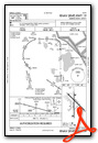
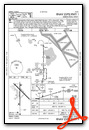
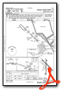
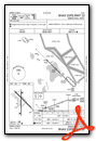
Instrument Approach Procedure (IAP) Charts
Nearby Airports with Instrument Procedures
| ID | Name | Heading / Distance | ||
|---|---|---|---|---|
 |
KAVO | Avon Park Exec Airport | 309° | 12.8 |
|
KOBE | Okeechobee County Airport | 113° | 28.6 |
|
KCHN | Wauchula Municipal Airport | 277° | 28.9 |
|
X07 | Lake Wales Municipal Airport | 330° | 30.1 |
|
X06 | Arcadia Municipal Airport | 239° | 30.8 |
|
KBOW | Bartow Exec Airport | 321° | 37.4 |
|
KGIF | Winter Haven Regional Airport | 329° | 42.4 |
|
X14 | La Belle Municipal Airport | 186° | 43.1 |
|
2IS | Airglades Airport | 160° | 45.9 |
|
KPGD | Punta Gorda Airport | 227° | 47.3 |
|
KLAL | Lakeland Linder International Airport | 311° | 48.0 |
|
X26 | Sebastian Municipal Airport | 064° | 49.9 |
Airport Images

By: ULP11550


