Login
Register


VRB
Vero Beach Regional Airport
Official FAA Data Effective 2025-11-27 0901Z
Chart Supplement

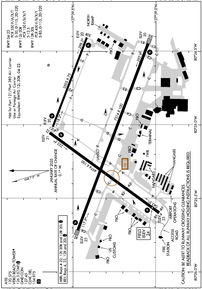
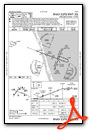
KVRB Airport Diagram
VFR Chart of KVRB
Sectional Charts at SkyVector.com
IFR Chart of KVRB
Enroute Charts at SkyVector.com
Location Information for KVRB
Coordinates: N27°39.33' / W80°25.08'Located 01 miles NW of Vero Beach, Florida on 1707 acres of land. View all Airports in Florida.
Surveyed Elevation is 23 feet MSL.
Operations Data
|
|
Airport Communications
| ATIS: | 120.575 |
|---|---|
| ASOS: | 120.575 Tel. 772-978-9535 |
| VERO BEACH TOWER: | 126.3 133.15 |
| VERO BEACH GROUND: | 127.45 |
| PALM BEACH APPROACH: | 123.625 ;NORTH 225.4 ;NORTH |
| PALM BEACH DEPARTURE: | 123.625 ;NORTH 225.4 ;NORTH |
| CLEARANCE DELIVERY: | 134.975 |
| UNICOM: | 122.950 |
| CTAF: | 126.300 |
| ASOS at FPR (9.7 S): | 772-489-4281 |
| ATIS at FPR (9.8 S): | 134.825 |
| AWOS-3PT at X26 (10.2 N): | 118.125 772-228-7020 |
Nearby Navigation Aids
|
| ||||||||||||||||||||||||||||||||||||||||||


Runway 12R/30L
| Dimensions: | 7314 x 100 feet / 2229 x 30 meters | |
|---|---|---|
| Surface: | Asphalt / Grooved in Excellent Condition | |
| Weight Limits: | S-85, D-115, ST-220
PCR VALUE: 450/F/B/X/T
| |
| Edge Lighting: | Medium Intensity | |
| Runway 12R | Runway 30L | |
| Coordinates: | N27°39.47' / W80°25.72' | N27°39.05' / W80°24.45' |
| Elevation: | 23.3 | 20.1 |
| Traffic Pattern: | Right | Left |
| Runway Heading: | 111° True | 291° True |
| Declared Distances: | TORA:7314 TODA:7314 ASDA:7314 LDA:7314 | TORA:7314 TODA:7314 ASDA:7276 LDA:7276 |
| Markings: | Precision Instrument in good condition. | Non-Precision Instrument in good condition. |
| Glide Slope Indicator | P4L (3.00° Glide Path Angle) | P4L (3.00° Glide Path Angle) |
| REIL: | Yes | Yes |
| Obstacles: | 66 ft Trees 2790 ft from runway, 30 ft left of center | 40 ft Trees 1965 ft from runway, 315 ft right of center |
Runway 04/22
RWY 04/22 NOT AVBL FOR PART 121/PART 380 OPS WITH SKED PAX CARRYING OPS MORE THAN 9 PAX SEATS AND NON-SKED PAX CARRYING OPS MORE THAN 30 PAX SEATS. | ||
| Dimensions: | 4974 x 100 feet / 1516 x 30 meters | |
|---|---|---|
| Surface: | Asphalt / Grooved in Good Condition | |
| Weight Limits: | S-30, D-115, ST-220
PCR VALUE: 350/F/A/X/T
| |
| Edge Lighting: | Medium Intensity | |
| Runway 04 | Runway 22 | |
| Coordinates: | N27°38.98' / W80°25.60' | N27°39.64' / W80°25.06' |
| Elevation: | 23.4 | 20.6 |
| Runway Heading: | 36° True | 216° True |
| Declared Distances: | TORA:4974 TODA:4974 ASDA:4974 LDA:4974 | TORA:4974 TODA:4974 ASDA:4945 LDA:4945 |
| Markings: | Non-Precision Instrument in good condition. | Non-Precision Instrument in good condition. |
| Glide Slope Indicator | P4L (3.00° Glide Path Angle) | P4L (3.00° Glide Path Angle) |
| REIL: | Yes | Yes |
| Obstacles: | 35 ft Trees 1395 ft from runway, 250 ft right of center | 55 ft Trees 2070 ft from runway, 80 ft left of center |
Runway 12L/30R
RWY 12L/30R NOT AVBL FOR PART 121/PART 380 OPS WITH SKED PAX CARRYING OPS MORE THAN 9 PAX SEATS AND NON-SKED PAX CARRYING OPS MORE THAN 30 PAX SEATS. | ||
| Dimensions: | 3505 x 75 feet / 1068 x 23 meters | |
|---|---|---|
| Surface: | Asphalt in Fair Condition | |
| Weight Limits: | S-12
PCR VALUE: 150/F/B/X/T
| |
| Edge Lighting: | Medium Intensity | |
| Runway 12L | Runway 30R | |
| Coordinates: | N27°39.62' / W80°25.01' | N27°39.42' / W80°24.41' |
| Elevation: | 19.5 | 19.6 |
| Traffic Pattern: | Right | |
| Runway Heading: | 111° True | 291° True |
| Declared Distances: | TORA:3505 TODA:3505 ASDA:3505 LDA:3505 | TORA:3505 TODA:3505 ASDA:3505 LDA:3505 |
| Markings: | Basic in fair condition. | Basic in fair condition. |
| Glide Slope Indicator | P2L (3.00° Glide Path Angle) | P2L (3.50° Glide Path Angle) |
| Obstacles: | 51 ft Trees 1630 ft from runway, 135 ft right of center | 35 ft Trees 1120 ft from runway, 80 ft right of center |
Services Available
| Fuel: | 100 (green), Jet-A |
|---|---|
| Transient Storage: | Hangars,Tiedowns |
| Airframe Repair: | MAJOR |
| Engine Repair: | MAJOR |
| Bottled Oxygen: | HIGH/LOW |
| Bulk Oxygen: | NONE |
| Other Services: | AIR FREIGHT SERVICES,AIR AMBULANCE SERVICES,AVIONICS,CHARTER SERVICE,PILOT INSTRUCTION,AIRCRAFT RENTAL,AIRCRAFT SALES |
Ownership Information
| Ownership: | Publicly owned | |
|---|---|---|
| Owner: | CITY OF VERO BEACH | |
| PO BOX 1389 | ||
| VERO BEACH, FL 32960 | ||
| 772-978-5151 | ||
| Manager: | TODD SCHER | |
| 3400 CHEROKEE DRIVE | ||
| VERO BEACH, FL 32960-1389 | ||
| 772-978-4930 | EXT 104. | |
Other Remarks
- FLT TRNG ON & INVOF ARPT.
- TWY B & F OPS FOR ACFT WITH WINGSPAN OF MORE THAN 79 FT AT PILOTS DISCRETION - AMGR.
- GLDR OPS INVOF X52 ARPT APRXLY 8 NM WSW.
- NOISE SENSITIVE ARPT; JET ACFT USE NATL BUS ACFT ASSOCIATION NOISE ABATEMENT PROC.
- VOLUNTARY LOCAL NOISE ABATEMENT PROC IN EFCT - AMGR.
- INT DEP NA EXC BY ATC REQUEST.
- RSCD NOT MNT 2300-0600 M-F 1530-0600 WKEND AND HOL.
- FOR CD IF UNA TO CTC ON FSS FREQ, CTC PALM BEACH APCH AT 561-275-1430.
- WHEN ATCT CLSD, ACTVT REIL RWY 04, 12R, 22 & 30L; PAPI RWY 4, 12R, 12L, 22, 30R & 30L; MIRL RWY 4/22, 12R/30L, 12L/30R - CTAF
Weather Minimums

Instrument Approach Procedure (IAP) Charts

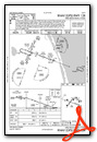
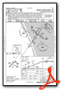
Nearby Airports with Instrument Procedures
| ID | Name | Heading / Distance | ||
|---|---|---|---|---|
 |
KFPR | Treasure Coast International Airport | 165° | 9.8 |
|
X26 | Sebastian Municipal Airport | 336° | 10.3 |
|
X59 | Valkaria Airport | 337° | 19.7 |
|
KMLB | Melbourne Orlando International Airport | 335° | 29.4 |
|
KSUA | Witham Field Airport | 159° | 30.2 |
|
KOBE | Okeechobee County Airport | 224° | 32.8 |
|
KCOF | Patrick Space Force Base Airport | 343° | 36.1 |
|
KCOI | Merritt Island Airport | 340° | 43.4 |
|
06FA | William P Gwinn Airport | 173° | 45.0 |
|
KXMR | Cape Canaveral Space Force Station Skid Strip Airport | 350° | 49.2 |
|
F45 | North Palm Beach County General Aviation Airport | 167° | 49.6 |
|
KSEF | Sebring Regional Airport | 256° | 50.7 |
Fuel Providers

Airport Images
Do you have a recent image of this airport? Upload it here!


Comments
Wonderful restaurant
Wonderful restaurant