Login
Register


X23
Umatilla Municipal Airport
Official FAA Data Effective 2026-01-22 0901Z
Chart Supplement

VFR Chart of X23
Sectional Charts at SkyVector.com
IFR Chart of X23
Enroute Charts at SkyVector.com
Location Information for X23
Coordinates: N28°55.48' / W81°39.11'Located 01 miles E of Umatilla, Florida on 65 acres of land. View all Airports in Florida.
Surveyed Elevation is 106 feet MSL.
Operations Data
|
|
Airport Communications
| ORLANDO APPROACH: | 135.3 351.9 |
|---|---|
| ORLANDO DEPARTURE: | 135.3 351.9 |
| CTAF: | 122.900 |
| ATIS at LEE (10.3 SW): | 134.325 |
| ASOS at LEE (10.4 SW): | 352-787-1565 |
| AWOS-3 at DED (21.0 NE): | 119.575 386-740-5811 |
Nearby Navigation Aids
|
| ||||||||||||||||||||||||||||||||||||||||||


Runway 01/19
| Dimensions: | 2876 x 60 feet / 877 x 18 meters | |
|---|---|---|
| Surface: | Asphalt in Excellent Condition | |
| Weight Limits: | 8 /F/A/Y/T, S-31, D-48 | |
| Edge Lighting: | Medium Intensity | |
| Runway 01 | Runway 19 | |
| Coordinates: | N28°55.25' / W81°39.12' | N28°55.72' / W81°39.09' |
| Elevation: | 100.6 | 105.7 |
| Traffic Pattern: | Left | Left |
| Runway Heading: | 3° True | 183° True |
| Displaced Threshold: | 201 Feet | |
| Markings: | Non-Precision Instrument in good condition. | Non-Precision Instrument in good condition. |
| Glide Slope Indicator | P2R (3.50° Glide Path Angle) | P2L (3.50° Glide Path Angle) |
| Obstacles: | 37 ft Trees 380 ft from runway, 125 ft left of center RWY 01 APCH SLP 16:1 TO DTHR. |
16 ft Brush 340 ft from runway, 30 ft left of center RWY 19 APCH SLP 24:1 TO DTHR. |
Services Available
| Fuel: | 100 (green), 100LL (blue) |
|---|---|
| Transient Storage: | Tiedowns |
| Airframe Repair: | NONE |
| Engine Repair: | NONE |
| Bottled Oxygen: | NONE |
| Bulk Oxygen: | NONE |
| Other Services: | PILOT INSTRUCTION |
Ownership Information
| Ownership: | Publicly owned | |
|---|---|---|
| Owner: | CITY OF UMATILLA | |
| PO BOX 2286 | ||
| UMATILLA, FL 32784-2286 | ||
| 352-669-3125 | ||
| Manager: | AARON MERCER | |
| PO BOX 2286 | AIRPORT PHYSICAL ADDRESS: 1 UMATILLA AIRPORT WAY, UMATILLA, FL 32784 | |
| UMATILLA, FL 32784-2286 | ||
| 352-669-3125 | ||
Other Remarks
- FOR CD OR TO CNL IFR CTC ORLANDO APCH AT 407-852-7500.
- UNLGTD OBSTRUCTIONS IN THE APPRCH TO RWY 01 DUE TO TREES 380 FT BFR AER.
- ACTVT PAPI RWY 01 & 19; MIRL RWY 01/19- CTAF.
Weather Minimums
Instrument Approach Procedure (IAP) Charts


Nearby Airports with Instrument Procedures
| ID | Name | Heading / Distance | ||
|---|---|---|---|---|
 |
KLEE | Leesburg International Airport | 233° | 10.3 |
|
X04 | Orlando Apopka Airport | 164° | 13.6 |
|
KDED | Deland Municipal-Sidney H Taylor Field Airport | 066° | 21.2 |
|
KSFB | Orlando Sanford International Airport | 111° | 23.7 |
|
KORL | Orlando Exec Airport | 143° | 28.2 |
|
7FL6 | Spruce Creek Airport | 073° | 33.2 |
|
KOCF | Ocala International-Jim Taylor Field Airport | 296° | 33.5 |
|
KDAB | Daytona Beach International Airport | 063° | 34.8 |
|
KMCO | Orlando International Airport | 148° | 34.7 |
|
KINF | Inverness Airport | 258° | 35.9 |
|
KOMN | Ormond Beach Municipal Airport | 051° | 36.2 |
|
KEVB | New Smyrna Beach Municipal (Jack Bolt Field) Airport | 077° | 37.8 |
Airport Images
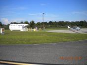
By: ULP11550


Comments
A big thank you to the City
A big thank you to the City of Umatilla for a great airfield and reasonably priced Avgas!! Thank you!