Login
Register


XS30
Burress Airport
Official FAA Data Effective 2025-12-25 0901Z
VFR Chart of XS30
Sectional Charts at SkyVector.com
IFR Chart of XS30
Enroute Charts at SkyVector.com
Location Information for XS30
Coordinates: N33°36.31' / W95°28.91'Located 03 miles SE of Paris, Texas. View all Airports in Texas.
Estimated Elevation is 484 feet MSL.
Operations Data
|
|
Airport Communications
| AWOS-3PT at PRX (2.5 NE): | 119.675 903-737-8784 |
|---|---|
| AWOS-3 at HHW (25.8 N): | 119.025 580-326-2134 |
| AWOS-3 at SLR (27.6 S): | 118.35 903-885-9605 |
Nearby Navigation Aids
|
| ||||||||||||||||||||||||||||||||||||||||||||||||||||||||||||


Runway 17/35
| Dimensions: | 2100 x 50 feet / 640 x 15 meters | |
|---|---|---|
| Surface: | Turf | |
| Runway 17 | Runway 35 | |
| Traffic Pattern: | Right | |
Ownership Information
| Ownership: | Privately Owned | |
|---|---|---|
| Owner: | JOE BURRESS | |
| 275 COUNTY ROAD 12200 | ||
| PARIS, TX 75462 | ||
| (903) 517-5583 | ||
| Manager: | JOE BURRESS | |
| 275 COUNTY ROAD 12200 | ||
| PARIS, TX 75462 | ||
| (903) 517-5583 | ||
Other Remarks
- FOR CD CTC FORT WORTH ARTCC AT 817-858-7584.
Nearby Airports with Instrument Procedures
| ID | Name | Heading / Distance | ||
|---|---|---|---|---|
 |
KPRX | Cox Field Airport | 039° | 2.4 |
|
KHHW | Stan Stamper Municipal Airport | 353° | 25.8 |
|
F53 | Franklin County Airport | 152° | 26.4 |
|
KSLR | Sulphur Springs Municipal Airport | 194° | 27.6 |
|
2F7 | Commerce Municipal Airport | 228° | 28.0 |
|
F00 | Jones Field Airport | 270° | 35.0 |
|
4O4 | Mc Curtain County Regional Airport | 059° | 36.1 |
|
80F | Antlers Municipal Airport | 346° | 36.2 |
|
KOSA | Mount Pleasant Regional Airport | 139° | 40.1 |
|
F51 | Winnsboro Municipal Airport | 165° | 41.2 |
|
KGVT | Majors Airport | 222° | 43.5 |
|
KDUA | Durant Regional/Eaker Field Airport | 293° | 49.9 |
Airport Images
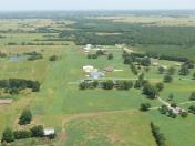
By: scgarrett3037


