Login
Register


08N
Keller Brothers Airport
Official FAA Data Effective 2026-02-19 0901Z
Chart Supplement

VFR Chart of 08N
Sectional Charts at SkyVector.com
IFR Chart of 08N
Enroute Charts at SkyVector.com
Location Information for 08N
Coordinates: N40°17.49' / W76°19.72'Located 05 miles SE of Lebanon, Pennsylvania on 25 acres of land. View all Airports in Pennsylvania.
Estimated Elevation is 550 feet MSL.
Operations Data
|
|
Airport Communications
| HARRISBURG APPROACH: | 126.45 281.525 |
|---|---|
| HARRISBURG DEPARTURE: | 126.45 281.525 |
| CTAF: | 122.900 |
| AWOS-2 at 9D4 (3.7 N): | 118.45 717-866-2906 |
| ASOS at LNS (10.3 S): | 125.675 717-568-6942 |
| ATIS at LNS (10.3 S): | 125.675 |
Nearby Navigation Aids
|
| ||||||||||||||||||||||||||||||||||||||||||||||||||||||||||||


Runway 07/25
THLDS AND DSPLCD THLDS MARKED WITH LGTS. | ||
| Dimensions: | 2692 x 120 feet / 821 x 37 meters | |
|---|---|---|
| Surface: | Turf in Good Condition | |
| Edge Lighting: | Non-Standard NSTD LIRL; RWY ENDS IDENTIFIED BY 2 STROBE LGTS & NSTD THLD LGT FIXTURES. | |
| Runway 07 | Runway 25 | |
| Coordinates: | N40°17.37' / W76°19.97' | N40°17.62' / W76°19.48' |
| Elevation: | 548.1 | 542.8 |
| Traffic Pattern: | Left | Left |
| Runway Heading: | 56° True | 236° True |
| Displaced Threshold: | 701 Feet | 793 Feet |
| Obstacles: | 26 ft Trees 64 ft from runway, 64 ft right of center APCH SLOPE 29:1 TO DTHR. |
45 ft Tree 28 ft from runway, 202 ft right of center CTLNG OBSTN EXCEEDS A 45 DEG SLP. |
Services Available
| Fuel: | 100LL (blue) |
|---|---|
| Transient Storage: | Tiedowns |
| Airframe Repair: | NONE |
| Engine Repair: | NONE |
| Bottled Oxygen: | NONE |
| Bulk Oxygen: | NONE |
Ownership Information
| Ownership: | Privately Owned | |
|---|---|---|
| Owner: | KELLER BROS ARPT INC | |
| 600 REXMONT RD | ||
| LEBANON, PA 17042 | ||
| 717-598-0057 | ||
| Manager: | CALEB KELLER | |
| 341 LAKEVIEW DR | ||
| LITITZ, PA 17543 | ||
| 717-598-0057 | ||
Other Remarks
- FOR CD CTC HARRISBURG APCH AT 800-932-0712.
- 0LL 100LL SELF SERVE
- ACTVT LIRL RWY 07/25 - 121.9.
- ACTVT ROTG BCN - 121.9.
Weather Minimums
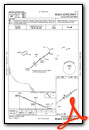
Instrument Approach Procedure (IAP) Charts

Nearby Airports with Instrument Procedures
| ID | Name | Heading / Distance | ||
|---|---|---|---|---|
 |
9D4 | Deck Airport | 359° | 3.6 |
|
KLNS | Lancaster Airport | 171° | 10.3 |
|
58N | Reigle Field Airport | 268° | 11.4 |
|
N71 | Donegal Springs Airpark Airport | 223° | 16.4 |
|
KRDG | Reading Regional/Carl A Spaatz Field Airport | 072° | 17.5 |
|
74N | Bendigo Airport | 326° | 19.2 |
|
KMDT | Harrisburg International Airport | 253° | 20.8 |
|
KCXY | Capital City Airport | 259° | 24.4 |
|
KZER | Schuylkill County/Joe Zerbey Airport | 355° | 25.0 |
|
KMQS | Chester County G O Carlson Airport | 131° | 28.4 |
|
N47 | Pottstown Municipal Airport | 093° | 30.3 |
|
KTHV | York Airport | 228° | 33.6 |


