Login
Register


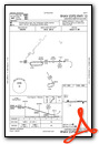
13C
Lakeview/Griffith Field Airport
Official FAA Data Effective 2026-02-19 0901Z
Chart Supplement

VFR Chart of 13C
Sectional Charts at SkyVector.com
IFR Chart of 13C
Enroute Charts at SkyVector.com
Location Information for 13C
Coordinates: N43°27.13' / W85°15.88'Located 01 miles NE of Lakeview, Michigan on 74 acres of land. View all Airports in Michigan.
Surveyed Elevation is 968 feet MSL.
Operations Data
|
|
Airport Communications
| GREAT LAKES APPROACH: | 124.6 257.6 |
|---|---|
| GREAT LAKES DEPARTURE: | 124.6 257.6 |
| CTAF: | 122.800 |
| UNICOM: | 122.800 |
| AWOS-3P at RQB (19.3 NW): | 125.875 231-796-0884 |
| AWOS-3P at MOP (24.9 NE): | 133.025 989-773-2885 |
| AWOS-3P at AMN (26.4 E): | 124.175 989-463-3433 |
- APCH/DEP SVC PRVDD BY CHICAGO ARTCC (ZAU) ON FREQS 132.275/254.35 (MUSKEGON RCAG) WHEN GREAT LAKES APCH CTL CLSD.
Nearby Navigation Aids
|
| ||||||||||||||||||||||||||||||||||||||||||||||||||||||


Runway 10/28
| Dimensions: | 3499 x 75 feet / 1066 x 23 meters | |
|---|---|---|
| Surface: | Asphalt in Good Condition | |
| Weight Limits: | S-12 | |
| Edge Lighting: | Medium Intensity | |
| Runway 10 | Runway 28 | |
| Coordinates: | N43°27.13' / W85°16.27' | N43°27.14' / W85°15.48' |
| Elevation: | 963.0 | 967.0 |
| Traffic Pattern: | Left | Left |
| Runway Heading: | 89° True | 269° True |
| Markings: | Non-Precision Instrument in good condition. | Non-Precision Instrument in good condition. |
| Glide Slope Indicator | P2L (3.00° Glide Path Angle) | P2L (3.00° Glide Path Angle) |
| REIL: | Yes | Yes |
| Obstacles: | 50 ft Tree 956 ft from runway, 380 ft left of center | |
Services Available
| Fuel: | 100LL (blue) |
|---|---|
| Transient Storage: | Tiedowns |
| Airframe Repair: | MAJOR |
| Engine Repair: | MAJOR |
| Bottled Oxygen: | NONE |
| Bulk Oxygen: | NONE |
| Other Services: | CROP DUSTING SERVICES |
Ownership Information
| Ownership: | Publicly owned | |
|---|---|---|
| Owner: | VILLAGE OF LAKEVIEW | |
| 208 S LINCOLN AVE, PO BOX 30 | ||
| LAKEVIEW, MI 48850-0030 | ||
| 989-352-6322 | ||
| Manager: | DARIN DOOD | |
| 208 S LINCOLN AVE, PO BOX 30 | ||
| LAKEVIEW, MI 48850-0030 | ||
| 989-289-3110 | CELL. | |
Other Remarks
- EXTSV AGRICULTURAL OPS.
- DEER & LRG BIRDS ON & INVOF ARPT.
- FOR CD CTC GREAT LAKES APCH AT 269-459-3344, WHEN APCH CLSD CTC CHICAGO ARTCC AT 630-906-8921.
- ACTVT REIL RWY 10 & 28; PAPI RWY 10 & 28; MIRL RWY 10/28 - CTAF.
Weather Minimums

Instrument Approach Procedure (IAP) Charts

Nearby Airports with Instrument Procedures
| ID | Name | Heading / Distance | ||
|---|---|---|---|---|
 |
6D6 | Greenville Municipal Airport | 178° | 18.6 |
|
KRQB | Roben-Hood Airport | 327° | 19.3 |
|
KMOP | Mount Pleasant Municipal Airport | 065° | 25.2 |
|
KAMN | Gratiot Community Airport | 106° | 26.4 |
|
8D4 | Paul C Miller/Sparta Airport | 223° | 26.6 |
|
KFFX | Fremont Municipal Airport | 268° | 31.9 |
|
Y70 | Ionia County Airport | 163° | 32.1 |
|
48D | Clare Municipal Airport | 044° | 32.4 |
|
7D3 | Baldwin Municipal Airport | 315° | 35.7 |
|
KGRR | Gerald R Ford International Airport | 198° | 36.1 |
|
KIKW | Jack Barstow Airport | 073° | 45.6 |
|
KMKG | Muskegon County Airport | 248° | 45.8 |
Airport Images
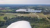
By: sunmanav8
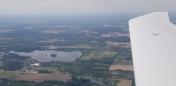
By: 15zenderb


