Login
Register


Y70
Ionia County Airport
Official FAA Data Effective 2025-11-27 0901Z
Chart Supplement

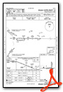
VFR Chart of Y70
Sectional Charts at SkyVector.com
IFR Chart of Y70
Enroute Charts at SkyVector.com
Location Information for Y70
Coordinates: N42°56.28' / W85°3.63'Located 03 miles S of Ionia, Michigan on 360 acres of land. View all Airports in Michigan.
Surveyed Elevation is 817 feet MSL.
Operations Data
|
|
Airport Communications
| AWOS-3: | 118.9 Tel. 616-523-1852 |
|---|---|
| GREAT LAKES APPROACH: | 118.65 226.4 |
| GREAT LAKES DEPARTURE: | 118.65 226.4 |
| UNICOM: | 122.800 |
| CTAF: | 122.800 |
| ASOS at GRR (20.6 W): | 616-986-5029 |
| ATIS at GRR (20.6 W): | 118.725 |
| ASOS at LAN (22.5 SE): | 517-908-8494 |
- APCH/DEP SVC PRVDD BY CHICAGO ARTCC (ZAU) ON FREQS 128.4 (GRAND RAPIDS RCAG) WHEN GREAT LAKES APCH CTL CLSD.
Nearby Navigation Aids
|
| ||||||||||||||||||||||||||||||||||||||||||||||||||||||


Runway 10/28
| Dimensions: | 4298 x 75 feet / 1310 x 23 meters | |
|---|---|---|
| Surface: | Asphalt in Fair Condition | |
| Weight Limits: | S-19 | |
| Edge Lighting: | Medium Intensity | |
| Runway 10 | Runway 28 | |
| Coordinates: | N42°56.28' / W85°4.26' | N42°56.27' / W85°3.30' |
| Elevation: | 813.8 | 802.4 |
| Traffic Pattern: | Left | Left |
| Runway Heading: | 91° True | 271° True |
| Markings: | Non-Precision Instrument in good condition. | Non-Precision Instrument in good condition. |
| Glide Slope Indicator | P4L (3.00° Glide Path Angle) | P4L (3.00° Glide Path Angle) |
| REIL: | Yes | |
Runway 18/36
RWY 18/36 MKD WITH 3 FT YELLOW CONES. | ||
| Dimensions: | 4261 x 340 feet / 1299 x 104 meters | |
|---|---|---|
| Surface: | Turf in Fair Condition | |
| Runway 18 | Runway 36 | |
| Coordinates: | N42°56.63' / W85°3.48' | N42°55.93' / W85°3.48' |
| Elevation: | 803.5 | 817.6 |
| Traffic Pattern: | Left | Left |
| Runway Heading: | 180° True | 0 |
| Obstacles: | 82 ft Tree 1242 ft from runway, 225 ft left of center | 73 ft Tree 986 ft from runway, 220 ft right of center ALSO +33 FT PLINE, 1015 FT DIST, 30:1. |
Services Available
| Fuel: | 100LL (blue) |
|---|---|
| Transient Storage: | Hangars,Tiedowns FOR HNGR AVBLTY CALL AMGR. |
| Airframe Repair: | MAJOR |
| Engine Repair: | MAJOR |
| Bottled Oxygen: | HIGH/LOW |
| Bulk Oxygen: | NONE |
| Other Services: | GLIDER SERVICE,PILOT INSTRUCTION,AIRCRAFT RENTAL,GLIDER TOWING SERVICES |
Ownership Information
| Ownership: | Publicly owned | |
|---|---|---|
| Owner: | IONIA COUNTY | |
| COURT HOUSE, 100 W MAIN ST | ||
| IONIA, MI 48846-1651 | ||
| 616-527-5300 | ||
| Manager: | MATT KUHNS | |
| 468 E SPRAGUE RD | ||
| IONIA, MI 48846 | ||
| 616-902-2281 | ||
Other Remarks
- EXTENSIVE SOARING ACTIVITY.
- GLDR OPS CONDUCTED S OF RWY 10/28 & WEST OF RWY 18/36; USE FREQ 123.3 IN PRACTICE AREA. GLDRS USE CTAF IN TFC PAT.
- TREES OBST VIEW BTWN RWY END 18 WITH RWY END 10 & 28.
- HOSPITAL & HOSPITAL HELI ADJ SOUTH OF RWY 10/28.
- FOR CD CTC GREAT LAKES APCH AT 269-459-3345, WHEN APCH CLSD CTC CHICAGO ARTCC AT 630-906-8921.
- 3 FT YELLOW CONES.
- ACTVT REIL RWY 28; PAPI RWY 10 & 28; MIRL RWY 10/28 - CTAF.
Weather Minimums


Instrument Approach Procedure (IAP) Charts

Nearby Airports with Instrument Procedures
| ID | Name | Heading / Distance | ||
|---|---|---|---|---|
 |
6D6 | Greenville Municipal Airport | 325° | 14.9 |
|
4D0 | Abrams Municipal Airport | 123° | 17.4 |
|
KGRR | Gerald R Ford International Airport | 260° | 20.7 |
|
9D9 | Hastings Airport | 217° | 20.7 |
|
KLAN | Capital Region International Airport | 114° | 23.0 |
|
KFPK | Fitch H Beach Airport | 153° | 24.4 |
|
KAMN | Gratiot Community Airport | 035° | 28.3 |
|
8D4 | Paul C Miller/Sparta Airport | 292° | 29.5 |
|
13C | Lakeview/Griffith Field Airport | 343° | 32.1 |
|
KTEW | Mason Jewett Field Airport | 128° | 35.9 |
|
KBTL | Battle Creek Exec At Kellogg Field Airport | 192° | 38.8 |
|
Z98 | Ottawa Exec Airport | 259° | 38.9 |
Airport Images

By: jimthepilotguy


