Login
Register


2CA4
Blackinton Airport
Official FAA Data Effective 2025-12-25 0901Z
VFR Chart of 2CA4
Sectional Charts at SkyVector.com
IFR Chart of 2CA4
Enroute Charts at SkyVector.com
Location Information for 2CA4
Coordinates: N33°15.54' / W117°5.54'Located 04 miles NW of Valley Center, California. View all Airports in California.
Estimated Elevation is 1156 feet MSL.
Operations Data
|
|
Airport Communications
| AWOS-3P at L18 (9.8 NW): | 118.425 760-723-6073 |
|---|---|
| ASOS at CRQ (12.1 SW): | 760-930-0864 |
| ATIS at CRQ (12.3 SW): | 120.15 |
Nearby Navigation Aids
|
| ||||||||||||||||||||||||||||||||||||||||||


Runway 17/35
| Dimensions: | 2200 x 50 feet / 671 x 15 meters | |
|---|---|---|
| Surface: | Asphalt in Good Condition | |
| Runway 17 | Runway 35 | |
| Displaced Threshold: | 130 Feet | |
| Markings: | Non-Precision Instrument | Non-Precision Instrument |
| Obstacles: | ft Power Lines Road ft from runway | |
Ownership Information
| Ownership: | Privately Owned | |
|---|---|---|
| Owner: | BLACKINTON AIRPORT HOA | |
| 30114 AIRFLIGHT DRIVE | ||
| VALLEY CENTER, CA 92082 | ||
| (760) 533-6077 | ||
| Manager: | PETER GORMAN | |
| 30210 AIRFLIGHT DRIVE | ||
| VALLEY CENTER, CA 92082 | ||
| (760) 533-6077 | ||
Other Remarks
- <LAND RWY 35, TKOF RWY 17.
- FOR CD CTC LOS ANGELES ARTCC AT 661-575-2079.
Nearby Airports with Instrument Procedures
| ID | Name | Heading / Distance | ||
|---|---|---|---|---|
 |
KCRQ | Mc Clellan-Palomar Airport | 230° | 12.3 |
|
KOKB | Bob Maxwell Memorial Airfield Airport | 259° | 13.3 |
|
KNFG | Camp Pendleton MCAS (Munn Field) Airport | 280° | 13.5 |
|
KRNM | Ramona Airport | 145° | 15.9 |
|
F70 | French Valley Airport | 354° | 19.0 |
|
KNKX | Miramar MCAS (Joe Foss Field) Airport | 186° | 23.5 |
|
KSEE | Gillespie Field Airport | 166° | 26.6 |
|
KMYF | Montgomery-Gibbs Exec Airport | 185° | 26.6 |
|
KHMT | Hemet-Ryan Airport | 007° | 28.7 |
|
KSAN | San Diego International Airport | 188° | 31.8 |
|
KNZY | North Island NAS (Halsey Field) Airport | 190° | 34.1 |
|
KRIV | March Arb Airport | 347° | 38.2 |
Airport Images
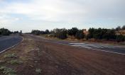
By: gvadiku
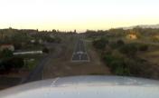
By: gvadiku


