Login
Register
F70
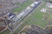
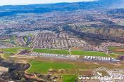
French Valley Airport
Official FAA Data Effective 2026-02-19 0901Z
VFR Chart of F70
Sectional Charts at SkyVector.com
IFR Chart of F70
Enroute Charts at SkyVector.com
Location Information for F70
Coordinates: N33°34.45' / W117°7.71'Located 02 miles NE of Murrieta/Temecula, California on 261 acres of land. View all Airports in California.
Surveyed Elevation is 1349 feet MSL.
Operations Data
|
|
Airport Communications
| AWOS-3: | 119.025 Tel. 951-696-1018 |
|---|---|
| MARCH APPROACH: | 133.5 306.975 134.0 278.3 |
| MARCH DEPARTURE: | 133.5 306.975 134.0 278.3 |
| UNICOM: | 122.800 |
| CTAF: | 122.800 |
| AWOS-3PT at HMT (10.7 NE): | 118.375 951-925-6886 |
| AWOS-3P at L18 (14.5 SW): | 118.425 760-723-6073 |
| ATIS at RIV (19.6 N): | 134.75 |
- MARCH (RIV) PROVIDES GROUND CONTROL APPROACH (GCA) RADAR.
Nearby Navigation Aids
|
| ||||||||||||||||||||||||||||||||||||||||||
Runway 18/36
| Dimensions: | 6000 x 75 feet / 1829 x 23 meters | |
|---|---|---|
| Surface: | Asphalt in Good Condition | |
| Weight Limits: | S-30, D-58 | |
| Edge Lighting: | Medium Intensity | |
| Runway 18 | Runway 36 | |
| Coordinates: | N33°34.93' / W117°7.58' | N33°33.97' / W117°7.84' |
| Elevation: | 1349.5 | 1339.5 |
| Traffic Pattern: | Right | |
| Runway Heading: | 192° True | 12° True |
| Markings: | Non-Precision Instrument in good condition. | Basic in good condition. |
| Glide Slope Indicator | P2L (3.00° Glide Path Angle) | P2L (3.00° Glide Path Angle) |
| REIL: | Yes | Yes |
| Obstacles: | 5 ft Road 425 ft from runway | |
Services Available
| Fuel: | 100LL (blue), Jet-A |
|---|---|
| Transient Storage: | Tiedowns |
| Airframe Repair: | MAJOR |
| Engine Repair: | MAJOR |
| Bottled Oxygen: | LOW |
| Bulk Oxygen: | NOT AVAILABLE |
| Other Services: | AIR AMBULANCE SERVICES,AVIONICS,CHARTER SERVICE,PILOT INSTRUCTION,AIRCRAFT RENTAL |
Ownership Information
| Ownership: | Publicly owned | |
|---|---|---|
| Owner: | COUNTY OF RIVERSIDE | |
| 4080 LEMON STREET, 14TH FLOOR | ||
| RIVERSIDE, CA 92501 | ||
| 951-955-9722 | ||
| Manager: | ANGELA JAMISON | |
| 4080 LEMON STREET, 14TH FLOOR | ||
| RIVERSIDE, CA 92501 | ||
| 951-955-9418 | ||
Other Remarks
- ALL DEPS - NOISE SENSITIVE AREAS IN VCNTY OF ARPT. BEST ROC RCMDD TO TFC PAT ALT BFR DEPARTING THE PAT. CALM WIND RWY 18.
- FOR CD CTC MARCH APCH AT 951-655-2355; WHEN MARCH APCH CLSD CTC SOCAL APCH AT 800-448-3724.
- 0LL SELF SERVICE 100LL FUEL AVAILABLE.
- FOR FUEL AFT HRS CALL 951-200-1706.
- ACTVT REIL RWY 18 & 36; PAPI RWY 18 & 36; MIRL RWY 18/36; TWY LGTS - CTAF.
Weather Minimums
Instrument Approach Procedure (IAP) Charts
Nearby Airports with Instrument Procedures
| ID | Name | Heading / Distance | ||
|---|---|---|---|---|
 |
KHMT | Hemet-Ryan Airport | 029° | 11.0 |
 |
KRIV | March Arb Airport | 340° | 19.6 |
 |
KNFG | Camp Pendleton MCAS (Munn Field) Airport | 214° | 19.9 |
 |
KOKB | Bob Maxwell Memorial Airfield Airport | 207° | 24.1 |
 |
KRAL | Riverside Airport | 325° | 27.6 |
 |
KCRQ | Mc Clellan-Palomar Airport | 195° | 27.8 |
 |
KRIR | Flabob Airport | 330° | 28.5 |
 |
KAJO | Corona Municipal Airport | 309° | 30.6 |
 |
KREI | Redlands Municipal Airport | 358° | 30.6 |
 |
KSBD | San Bernardino International Airport | 350° | 31.7 |
 |
KRNM | Ramona Airport | 161° | 33.8 |
 |
KPSP | Palm Springs International Airport | 063° | 34.7 |


