Login
Register
2CN4
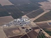
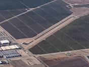
Wonderful Pistachios & Almonds Airport
Official FAA Data Effective 2025-11-27 0901Z
VFR Chart of 2CN4
Sectional Charts at SkyVector.com
IFR Chart of 2CN4
Enroute Charts at SkyVector.com
Location Information for 2CN4
Coordinates: N35°39.98' / W119°53.78'Located 10 miles NW of Lost Hills, California. View all Airports in California.
Estimated Elevation is 617 feet MSL.
Operations Data
|
|
Airport Communications
| AWOS-3P at DLO (32.4 E): | 119.55 661-721-2668 |
|---|---|
| AWOS-3 at C80 (35.5 NW): | 119.275 559-935-5960 |
| ASOS at PRB (35.6 W): | 120.125 805-239-3593 |
Nearby Navigation Aids
|
| ||||||||||||||||||||||||||||||||||||||||||||||||
Runway 13/31
| Dimensions: | 5002 x 60 feet / 1525 x 18 meters | |
|---|---|---|
| Surface: | Asphalt | |
| Edge Lighting: | Low Intensity | |
| Runway 13 | Runway 31 | |
| Glide Slope Indicator | V2L | V2L |
Ownership Information
| Ownership: | Privately Owned | |
|---|---|---|
| Owner: | WONDERFUL PISTACHIOS & ALMONDS | |
| 13646 HWY 33 | ||
| LOST HILLS, CA 93249 | ||
| 661-797-6505 | ||
| Manager: | DANIEL LEE | |
| 13646 HWY 33 | ||
| LOST HILLS, CA 93249 | ||
| 661-797-6505 | ||
Other Remarks
- 30 FT PLINE ONE HALF NM E OF RY.
- FOR CD CTC LOS ANGELES ARTCC AT 661-575-2079.
- DUSK-2200
Nearby Airports with Instrument Procedures
| ID | Name | Heading / Distance | ||
|---|---|---|---|---|
 |
KDLO | Delano Municipal Airport | 081° | 32.6 |
 |
C80 | New Coalinga Municipal Airport | 326° | 35.5 |
 |
KPRB | Paso Robles Municipal Airport | 270° | 35.7 |
 |
KMIT | Shafter-Minter Field Airport | 105° | 35.8 |
 |
KTLR | Mefford Field Airport | 043° | 40.4 |
 |
KHJO | Hanford Municipal Airport | 018° | 41.1 |
 |
KBFL | Meadows Field Airport | 108° | 43.4 |
 |
KSBP | San Luis Obispo County Regional Airport | 235° | 44.7 |
 |
KPTV | Porterville Municipal Airport | 061° | 46.1 |
 |
KVIS | Visalia Municipal Airport | 031° | 46.1 |
 |
L45 | Bakersfield Municipal Airport | 114° | 48.6 |
 |
KSMX | Santa Maria Pub/Capt G Allan Hancock Field Airport | 211° | 53.6 |


