Login
Register


C80
New Coalinga Municipal Airport
Official FAA Data Effective 2025-12-25 0901Z
Chart Supplement

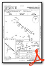
VFR Chart of C80
Sectional Charts at SkyVector.com
IFR Chart of C80
Enroute Charts at SkyVector.com
Location Information for C80
Coordinates: N36°9.73' / W120°17.69'Located 03 miles E of Coalinga, California on 1002 acres of land. View all Airports in California.
Estimated Elevation is 624 feet MSL.
Operations Data
|
|
Airport Communications
| AWOS-3: | 119.275 Tel. 559-935-5960 |
|---|---|
| UNICOM: | 122.700 |
| CTAF: | 122.700 |
| AWOS-3 at NLC (19.2 NE): | 121.575 559-998-2336 |
| ATIS at NLC (19.5 NE): | 121.575 |
| ASOS at PRB (33.5 SW): | 120.125 805-239-3593 |
- APCH/DEP CTLSVC PRVDD BY OAKLAND ARTCC (ZOA) ON 128.7/307.0 (PRIEST RCAG).
Nearby Navigation Aids
|
| ||||||||||||||||||||||||||||||||||||||||||||||||


Runway 12/30
| Dimensions: | 5000 x 100 feet / 1524 x 30 meters | |
|---|---|---|
| Surface: | Asphalt in Fair Condition | |
| Weight Limits: | S-30 | |
| Edge Lighting: | Medium Intensity | |
| Runway 12 | Runway 30 | |
| Coordinates: | N36°10.06' / W120°18.01' | N36°9.52' / W120°17.24' |
| Elevation: | 624.8 | 601.8 |
| Traffic Pattern: | Right | |
| Runway Heading: | 131° True | 311° True |
| Markings: | Non-Precision Instrument in fair condition. | Non-Precision Instrument in fair condition. |
| Glide Slope Indicator | P2L (3.00° Glide Path Angle) | P2L (3.00° Glide Path Angle) RWY 30 VGSI OTS. |
| REIL: | Yes | Yes |
Runway 01/19
RWY CLSD. | ||
| Dimensions: | 2471 x 60 feet / 753 x 18 meters | |
|---|---|---|
| Surface: | Asphalt-Gravel in Failed Condition RWY SFC FAILED WITH POTHOLES AND BRUSH. | |
| Weight Limits: | S-12 | |
| Runway 01 | Runway 19 | |
| Coordinates: | N36°9.39' / W120°17.86' | N36°9.79' / W120°17.76' |
| Elevation: | 606.9 | 608.0 |
| Traffic Pattern: | Right | |
| Runway Heading: | 12° True | 192° True |
| Markings: | Basic in poor condition. | Basic in poor condition. |
Helipad H1
| Dimensions: | 50 x 50 feet / 15 x 15 meters | |
|---|---|---|
| Surface: | Asphalt in Good Condition | |
| Edge Lighting: | Perimeter | |
| Coordinates: | N36°9.73' / W120°17.69' | N0°0.00' / E0°0.00' |
| Elevation: | 606.0 | |
| Markings: | Basic in good condition. | |
Services Available
| Fuel: | NONE |
|---|---|
| Transient Storage: | Tiedowns |
| Airframe Repair: | NOT AVAILABLE |
| Engine Repair: | NOT AVAILABLE |
| Bottled Oxygen: | NOT AVAILABLE |
| Bulk Oxygen: | NOT AVAILABLE |
Ownership Information
| Ownership: | Publicly owned | |
|---|---|---|
| Owner: | CITY OF COALINGA | |
| CITY HALL 155 W DURIAN | ||
| COALINGA, CA 93210 | ||
| 559-935-1533 | ||
| Manager: | MERCEDES GARCIA | MGARCIA@COALINGA.COM |
| THE CITY OF COALINGA, 155 W DURIAN | ||
| COALINGA, CA 93210-1911 | ||
| 559-246-6243 | ||
Other Remarks
- FOR CD CTC OAKLAND ARTCC AT 510-745-3380.
- AWOS OTS.
- REIL RWYS 12 & 30; MIRL RWY 12/30; PERIMETER LGTS H1 ON DUSK-0000; AFTER 0000 ACTVT - CTAF. PAPI RWYS 12 & 30 OPR CONSLY.
- DUSK-DAWN.
Weather Minimums
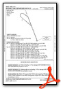
Instrument Approach Procedure (IAP) Charts
Departure Procedure Obstacles (DPO) Charts
Nearby Airports with Instrument Procedures
| ID | Name | Heading / Distance | ||
|---|---|---|---|---|
 |
KPRB | Paso Robles Municipal Airport | 209° | 33.5 |
|
KHJO | Hanford Municipal Airport | 073° | 33.7 |
|
KKIC | Mesa Del Rey Airport | 275° | 40.3 |
|
KFCH | Fresno Chandler Exec Airport | 033° | 41.2 |
|
F34 | Firebaugh Airport | 348° | 42.6 |
|
KVIS | Visalia Municipal Airport | 077° | 44.8 |
|
KFAT | Fresno Yosemite International Airport | 036° | 46.2 |
|
KTLR | Mefford Field Airport | 090° | 47.0 |
|
KMAE | Madera Municipal Airport | 010° | 50.3 |
|
O32 | Reedley Municipal Airport | 053° | 51.0 |
|
KDLO | Delano Municipal Airport | 115° | 57.3 |
|
KSBP | San Luis Obispo County Regional Airport | 197° | 58.0 |


