Login
Register
5Y2
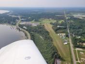
Houghton Lake State Airport
Official FAA Data Effective 2025-12-25 0901Z
VFR Chart of 5Y2
Sectional Charts at SkyVector.com
IFR Chart of 5Y2
Enroute Charts at SkyVector.com
Location Information for 5Y2
Coordinates: N44°19.87' / W84°47.46'Located 01 miles W of Houghton Lake Heights, Michigan on 121 acres of land. View all Airports in Michigan.
Surveyed Elevation is 1165 feet MSL.
Operations Data
|
|
Airport Communications
| CTAF: | 122.900 |
|---|---|
| ASOS at HTL (5.3 E): | 118.05 989-200-3352 |
| ATIS at GOV (21.1 N): | 119.075 |
| ASOS at GOV (21.1 N): | 989-348-3127 |
Nearby Navigation Aids
|
| ||||||||||||||||||||||||||||||||||||||||||||||||||||||||||||
Runway 16/34
| Dimensions: | 2750 x 104 feet / 838 x 32 meters | |
|---|---|---|
| Surface: | Turf in Good Condition | |
| Runway 16 | Runway 34 | |
| Coordinates: | N44°20.09' / W84°47.57' | N44°19.66' / W84°47.35' |
| Elevation: | 1165.0 | 1165.0 |
| Traffic Pattern: | Left | Left |
| Runway Heading: | 160° True | 340° True |
| Displaced Threshold: | 550 Feet | 900 Feet |
| Obstacles: | 53 ft Tree 0 ft from runway, 77 ft left of center CTLG OBSTN EXCEEDS A 45 DEG SLP. APCH RATIO 20:1 TO DTHR. |
23 ft Trees 64 ft from runway, 60 ft left of center APCH RATIO 18:1 TO DTHR OVR +88 FT TREES, 1795 FT DIST, 20 FT L. |
Services Available
| Fuel: | NONE |
|---|---|
| Transient Storage: | Tiedowns PILOTS MUST SUP ROPES. |
| Airframe Repair: | NONE |
| Engine Repair: | NONE |
| Bottled Oxygen: | NONE |
| Bulk Oxygen: | NONE |
Ownership Information
| Ownership: | Publicly owned | |
|---|---|---|
| Owner: | STATE OF MICHIGAN | |
| 2700 PORT LANSING RD | ||
| LANSING, MI 48906-2172 | ||
| 517-335-9681 | ||
| Manager: | CHRIS AMBROSE | |
| 125 CRISTI LN | ||
| HOUGHTON LAKE, MI 48629-9683 | ||
| 616-540-1324 | ||
Other Remarks
- SNOW REMOVAL IREG - CTC AMGR AT 616-540-1324 TO VFY CONDS.
- DEER & LRG BIRDS ON & INVOF ARPT.
- FOR CD CTC MINNEAPOLIS ARTCC AT 651-463-5588.
- RWY & DTHR MKD WITH 3 FT YELLOW CONES.
- RWY & DTHR MKD WITH 3 FT YELLOW CONES.
Nearby Airports with Instrument Procedures
| ID | Name | Heading / Distance | ||
|---|---|---|---|---|
 |
KHTL | Roscommon County/Blodgett Memorial Airport | 071° | 5.5 |
 |
KGOV | Grayling AAF Airport | 007° | 21.1 |
 |
KGDW | Gladwin Zettel Memorial Airport | 147° | 25.6 |
 |
Y31 | West Branch Community Airport | 100° | 26.8 |
 |
KCAD | Wexford County Airport | 263° | 27.3 |
 |
48D | Clare Municipal Airport | 175° | 29.9 |
 |
KGLR | Gaylord Regional Airport | 005° | 41.1 |
 |
KTVC | Cherry Capital Airport | 306° | 41.9 |
 |
KMOP | Mount Pleasant Municipal Airport | 176° | 42.6 |
 |
KACB | Antrim County Airport | 336° | 43.1 |
 |
KIKW | Jack Barstow Airport | 150° | 46.2 |
 |
KRQB | Roben-Hood Airport | 220° | 47.8 |


