Login
Register


GDW
Gladwin Zettel Memorial Airport
Official FAA Data Effective 2026-01-22 0901Z
Chart Supplement

VFR Chart of KGDW
Sectional Charts at SkyVector.com
IFR Chart of KGDW
Enroute Charts at SkyVector.com
Location Information for KGDW
Coordinates: N43°58.24' / W84°28.50'Located 01 miles SE of Gladwin, Michigan on 300 acres of land. View all Airports in Michigan.
Surveyed Elevation is 774 feet MSL.
Operations Data
|
|
Airport Communications
| GREAT LAKES APPROACH: | 126.45 235.625 |
|---|---|
| GREAT LAKES DEPARTURE: | 126.45 235.625 |
| UNICOM: | 122.800 |
| CTAF: | 122.800 |
| AWOS-3 at IKW (20.6 SE): | 119.525 989-835-5841 |
| AWOS-3P at Y31 (20.7 NE): | 119.575 989-787-1100 |
| AWOS-3 at MOP (23.8 SW): | 133.025 989-773-2885 |
- APCH/DEP SVC PRVDD BY CLEVELAND ARTCC (ZOB) ON FREQS 127.7/290.425 (FREELAND RCAG) WHEN GREAT LAKES APCH CTL CLSD.
Nearby Navigation Aids
|
| ||||||||||||||||||||||||||||||||||||||||||||||||||||||||||||


Runway 09/27
| Dimensions: | 4699 x 75 feet / 1432 x 23 meters | |
|---|---|---|
| Surface: | Asphalt in Good Condition | |
| Weight Limits: | S-44, D-60, ST-90 | |
| Edge Lighting: | Medium Intensity | |
| Runway 09 | Runway 27 | |
| Coordinates: | N43°58.30' / W84°28.97' | N43°58.34' / W84°27.90' |
| Elevation: | 771.3 | 772.7 |
| Traffic Pattern: | Left | Left |
| Runway Heading: | 88° True | 268° True |
| Markings: | Non-Precision Instrument in good condition. | Non-Precision Instrument in good condition. |
| Glide Slope Indicator | P4L (3.75° Glide Path Angle) | P4L (3.00° Glide Path Angle) |
| REIL: | Yes | Yes |
| Obstacles: | 34 ft Tree 856 ft from runway, 343 ft left of center | |
Runway 15/33
CLSD WHEN SNOW COVD EXC FOR SKI EQUIPPED ACFT. | ||
| Dimensions: | 2580 x 150 feet / 786 x 46 meters | |
|---|---|---|
| Surface: | Turf in Fair Condition | |
| Runway 15 | Runway 33 | |
| Coordinates: | N43°58.28' / W84°28.73' | N43°57.89' / W84°28.50' |
| Elevation: | 772.7 | 764.3 |
| Traffic Pattern: | Left | Left |
| Runway Heading: | 157° True | 337° True |
| Obstacles: | 9 ft Tree 93 ft from runway, 133 ft left of center | |
Services Available
| Fuel: | 100LL (blue), Jet A+ |
|---|---|
| Transient Storage: | Tiedowns |
| Airframe Repair: | NOT AVAILABLE |
| Engine Repair: | NOT AVAILABLE |
| Bottled Oxygen: | NOT AVAILABLE |
| Bulk Oxygen: | NOT AVAILABLE |
Ownership Information
| Ownership: | Publicly owned | |
|---|---|---|
| Owner: | CITY/CO OF GLADWIN | |
| 1000 W CEDAR AVE | ||
| GLADWIN, MI 48624-1814 | ||
| 989-426-9231 | CITY HALL. | |
| Manager: | MICHAEL HARGRAVE | |
| 735 S STATE ST | ||
| GLADWIN, MI 48624-2258 | ||
| 989-426-4201 | CELL 989-578-2174. | |
Other Remarks
- DEER & LRG BIRDS ON & INVOF ARPT.
- UAS OPR WEST OF RWY 15/33.
- TRML BLDG ACES: 5-3-2-1-*.
- FOR CD CTC GREAT LAKES APCH AT 269-459-3345, WHEN APCH CLSD CTC CLEVELAND ARTCC AT 440-774-0224/0490.
- 3 FT YELLOW CONES.
- 3 FT YELLOW CONES.
- 0LL 100LL AVBL H24 SELF SVC VIA CREDIT CARD. JET A+ AVBL FULL SVC DURG BUS HRS OR BY ARNGMT.
- ACTVT REIL RWY 09 & 27; PAPI RWY 09 & 27; MIRL RWY 09/27 - CTAF.
Weather Minimums

Instrument Approach Procedure (IAP) Charts
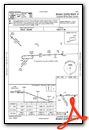
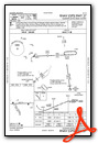
Nearby Airports with Instrument Procedures
| ID | Name | Heading / Distance | ||
|---|---|---|---|---|
 |
48D | Clare Municipal Airport | 234° | 14.1 |
|
KIKW | Jack Barstow Airport | 153° | 20.7 |
|
Y31 | West Branch Community Airport | 037° | 20.8 |
|
KMOP | Mount Pleasant Municipal Airport | 208° | 23.8 |
|
KHTL | Roscommon County/Blodgett Memorial Airport | 340° | 24.8 |
|
KMBS | Mbs International Airport | 146° | 31.4 |
|
3CM | James Clements Municipal Airport | 135° | 35.8 |
|
KAMN | Gratiot Community Airport | 193° | 40.0 |
|
KHYX | Saginaw County/H W Browne Airport | 140° | 41.8 |
|
KGOV | Grayling AAF Airport | 345° | 44.0 |
|
KCAD | Wexford County Airport | 294° | 44.7 |
|
13C | Lakeview/Griffith Field Airport | 228° | 46.3 |
Airport Images
Do you have a recent image of this airport? Upload it here!


