Login
Register
HTL
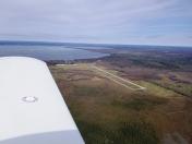
Roscommon County/Blodgett Memorial Airport
Official FAA Data Effective 2026-01-22 0901Z
VFR Chart of KHTL
Sectional Charts at SkyVector.com
IFR Chart of KHTL
Enroute Charts at SkyVector.com
Location Information for KHTL
Coordinates: N44°21.59' / W84°40.17'Located 05 miles NE of Houghton Lake, Michigan on 419 acres of land. View all Airports in Michigan.
Surveyed Elevation is 1149 feet MSL.
Operations Data
|
|
Airport Communications
| ASOS: | 118.05 Tel. 989-200-3352 |
|---|---|
| UNICOM: | 122.800 |
| CTAF: | 122.800 |
| ATIS at GOV (19.4 N): | 119.075 |
| ASOS at GOV (19.4 N): | 989-348-3127 |
| AWOS-3P at Y31 (22.2 E): | 119.575 989-787-1100 |
- APCH/DEP SVC PRVDD BY MINNEAPOLIS ARTCC ON 125.475/269.45 (ALPENA RCAG).
Nearby Navigation Aids
|
| ||||||||||||||||||||||||||||||||||||||||||||||||||||||||||||
Runway 09/27
| Dimensions: | 4000 x 75 feet / 1219 x 23 meters | |
|---|---|---|
| Surface: | Asphalt in Good Condition | |
| Weight Limits: | S-24 | |
| Edge Lighting: | High Intensity | |
| Runway 09 | Runway 27 | |
| Coordinates: | N44°21.67' / W84°40.44' | N44°21.69' / W84°39.52' |
| Elevation: | 1147.8 | 1144.7 |
| Traffic Pattern: | Left | Left |
| Runway Heading: | 89° True | 269° True |
| Markings: | Non-Precision Instrument in good condition. | Non-Precision Instrument in good condition. |
| Glide Slope Indicator | P4L (3.50° Glide Path Angle) | P4R (3.50° Glide Path Angle) |
| REIL: | Yes | Yes |
| Obstacles: | 65 ft Trees 1545 ft from runway, 120 ft right of center | 12 ft Brush 315 ft from runway, 130 ft left of center |
Runway 18/36
CLSD WHEN SNOW COVD EXC FOR SKI EQUIPPED ACFT. | ||
| Dimensions: | 2200 x 100 feet / 671 x 30 meters | |
|---|---|---|
| Surface: | Turf in Good Condition | |
| Runway 18 | Runway 36 | |
| Coordinates: | N44°21.61' / W84°40.52' | N44°21.25' / W84°40.51' |
| Elevation: | 1148.3 | 1144.3 |
| Traffic Pattern: | Left | Left |
| Runway Heading: | 178° True | 358° True |
| Displaced Threshold: | 200 Feet | |
| Obstacles: | 99 ft Tree 1815 ft from runway, 324 ft left of center | 23 ft Tree 0 ft from runway, 156 ft right of center CTLG OBSTN EXCEEDS A 45 DEG SLP. APCH RATIO 13:1 TO DTHR OVR 23 FT TREE, 248 FT DIST, 156 FT R. |
Services Available
| Fuel: | 100LL (blue) |
|---|---|
| Transient Storage: | Tiedowns |
| Airframe Repair: | MAJOR |
| Engine Repair: | MAJOR |
| Bottled Oxygen: | NONE |
| Bulk Oxygen: | NONE |
| Other Services: | PILOT INSTRUCTION |
Ownership Information
| Ownership: | Publicly owned | |
|---|---|---|
| Owner: | ROSCOMMON COUNTY | |
| 500 LAKE ST | ||
| ROSCOMMON, MI 48653-7664 | ||
| 989-275-8021 | ||
| Manager: | ERIC J JAROCH | |
| 5220 E HOUGHTON LAKE DR | ||
| HOUGHTON LAKE, MI 48629-8313 | ||
| 989-366-7660 | ||
Other Remarks
- DEER & LRG BIRDS ON & INVOF ARPT.
- 2203 FT MSL (883 AGL) TOWER 4.2 NM SW OF ARPT.
- FOR CD CTC MINNEAPOLIS ARTCC AT 651-463-5588.
- 3 FT YELLOW CONES.
- 3 FT YELLOW CONES.
- ACTVT OR INCR INTST REIL RWY 09 & 27; PAPI RWY 09 & 27; HIRL RWY 09/27 - CTAF. HIRL RWY 09/27 PRESET LOW INTST DUSK-2100.
Weather Minimums
Instrument Approach Procedure (IAP) Charts
Nearby Airports with Instrument Procedures
| ID | Name | Heading / Distance | ||
|---|---|---|---|---|
 |
KGOV | Grayling AAF Airport | 352° | 19.4 |
 |
Y31 | West Branch Community Airport | 107° | 22.2 |
 |
KGDW | Gladwin Zettel Memorial Airport | 160° | 24.8 |
 |
48D | Clare Municipal Airport | 185° | 31.7 |
 |
KCAD | Wexford County Airport | 261° | 32.7 |
 |
KGLR | Gaylord Regional Airport | 357° | 39.2 |
 |
KACB | Antrim County Airport | 329° | 44.0 |
 |
KMOP | Mount Pleasant Municipal Airport | 183° | 44.4 |
 |
KTVC | Cherry Capital Airport | 300° | 45.4 |
 |
KIKW | Jack Barstow Airport | 156° | 45.4 |
 |
KBFA | Boyne Mountain Airport | 347° | 49.6 |
 |
KRQB | Roben-Hood Airport | 223° | 52.6 |


