Login
Register
9W8
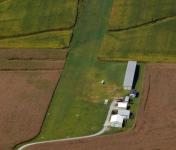
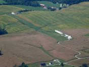
Baublitz Commercial Airport
Official FAA Data Effective 2026-01-22 0901Z
VFR Chart of 9W8
Sectional Charts at SkyVector.com
IFR Chart of 9W8
Enroute Charts at SkyVector.com
Location Information for 9W8
Coordinates: N39°51.14' / W76°29.18'Located 01 miles S of Brogue, Pennsylvania on 12 acres of land. View all Airports in Pennsylvania.
Estimated Elevation is 750 feet MSL.
Operations Data
|
|
Airport Communications
| CTAF: | 122.900 |
|---|---|
| ASOS at THV (18.2 W): | 119.275 717-792-5529 |
| ATIS at LNS (18.5 NE): | 125.675 |
| ASOS at LNS (18.5 NE): | 125.675 717-568-6942 |
Nearby Navigation Aids
|
| ||||||||||||||||||||||||||||||||||||||||||||||||||||||||||||
Runway 10/28
| Dimensions: | 2493 x 100 feet / 760 x 30 meters | |
|---|---|---|
| Surface: | Turf in Good Condition RWY 28 AT W END LAST 400 FT SLOPES DOWNWARD 16 FT. | |
| Runway 10 | Runway 28 | |
| Traffic Pattern: | Left | Left |
| Displaced Threshold: | 476 Feet RWY 10 DSPLCD THLD MKD BY 3 W FLUSH MKRS EACH SIDE OF RWY. |
200 Feet RWY 28 DSPLCD THLD MKD BY 3 W FLUSH MKRS EACH SIDE OF RWY. |
| Obstacles: | 45 ft Pole 34 ft from runway, 111 ft left of center CTLNG OBSTN EXCEEDS A 45 DEG SLP. |
10 ft Road 6 ft from runway RD TRAVERSING AER 28 IS A PVT GRVL RD WITH VEHICLES CONTROLLED BY STOP SIGNS. RWY 28 APCH RATIO 20:1 TO DSPLCD THLD. |
Services Available
| Fuel: | 100LL (blue) |
|---|---|
| Transient Storage: | Tiedowns |
| Airframe Repair: | MINOR |
| Engine Repair: | MINOR |
| Bottled Oxygen: | NONE |
| Bulk Oxygen: | NONE |
| Other Services: | PILOT INSTRUCTION |
Ownership Information
| Ownership: | Privately Owned | |
|---|---|---|
| Owner: | CHANCEFORD AVIATION | |
| 3354 WARNER RD | ||
| BROGUE, PA 17309 | ||
| 717-870-4076 | ||
| Manager: | BRUCE EVELER | |
| 3354 WARNER RD | ||
| BROGUE, PA 17309 | ||
| (717) 870-4076 | ||
Other Remarks
- NO WINTER SNOW REMOVAL.
- FOR CD CTC POTOMAC APCH AT 866-429-5882.
- RWY 10/28 EDGES AND RWY ENDS MKD BY W FLUSH PAINTED MKRS CO-LOCATED WITH ORANGE CONES.
Nearby Airports with Instrument Procedures
| ID | Name | Heading / Distance | ||
|---|---|---|---|---|
 |
N71 | Donegal Springs Airpark Airport | 344° | 14.9 |
 |
KTHV | York Airport | 282° | 18.3 |
 |
KLNS | Lancaster Airport | 028° | 18.5 |
 |
0W3 | Harford County Airport | 142° | 21.4 |
 |
KMDT | Harrisburg International Airport | 328° | 24.1 |
 |
58N | Reigle Field Airport | 350° | 26.4 |
 |
08N | Keller Brothers Airport | 015° | 27.3 |
 |
KCXY | Capital City Airport | 322° | 27.6 |
 |
KDMW | Carroll County Regional/Jack B Poage Field Airport | 238° | 28.2 |
 |
KMQS | Chester County G O Carlson Airport | 074° | 29.7 |
 |
9D4 | Deck Airport | 013° | 30.8 |
 |
KMTN | Martin State Airport | 173° | 31.8 |


