Login
Register


AFM
Ambler Airport
Official FAA Data Effective 2025-12-25 0901Z
Chart Supplement

VFR Chart of PAFM
Sectional Charts at SkyVector.com
IFR Chart of PAFM
Enroute Charts at SkyVector.com
Location Information for PAFM
Coordinates: N67°6.37' / W157°51.43'Located 01 miles N of Ambler, Alaska on 272 acres of land. View all Airports in Alaska.
Surveyed Elevation is 292 feet MSL.
Operations Data
|
|
Airport Communications
| AWOS-3P: | 132.1 Tel. 907-445-2146 |
|---|---|
| CTAF: | 122.700 |
| AWOS-3P at SHG (20.9 SE): | 118.525 907-560-7612 |
- APCH/DEP SVC PRVDD BY ANCHORAGE ARTCC FREQS 119.2/263.0 (KOTZEBUE RCAG).
- COMMUNICATIONS PRVDD BY KOTZEBUE FSS ON FREQ 122.0 (AMBLER RCO).
Nearby Navigation Aids
|
| ||||||||||||
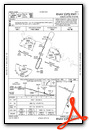
Runway 01/19
CROWNS IN CENTER & NO LINE OF SIGHT BTW RWY ENDS. | ||
| Dimensions: | 4000 x 75 feet / 1219 x 23 meters | |
|---|---|---|
| Surface: | Gravel-Dirt in Good Condition RWY SURFACE IS COMPACTED GRAVEL, ROCK AND DIRT. SURFACE TYPE LISTED AS GRAVEL-DIRT. | |
| Edge Lighting: | Medium Intensity | |
| Runway 01 | Runway 19 | |
| Coordinates: | N67°6.00' / W157°51.64' | N67°6.60' / W157°50.99' |
| Elevation: | 248.5 | 268.3 |
| Traffic Pattern: | Left | Left |
| Runway Heading: | 23° True | 203° True |
| Markings: | Non-Precision Instrument in fair condition. | Non-Precision Instrument in fair condition. |
| Glide Slope Indicator | P4R (3.00° Glide Path Angle) | |
| Obstacles: | 10 ft Trees 315 ft from runway, 140 ft right of center | 13 ft Trees 0 ft from runway, 180 ft right of center |
Runway 10/28
RWY SLOPES UPHILL EAST TO WEST APPX 80 FT. | ||
| Dimensions: | 2400 x 60 feet / 732 x 18 meters | |
|---|---|---|
| Surface: | Gravel-Dirt in Good Condition RWY SURFACE IS COMPACTED GRAVEL, ROCK AND DIRT. SURFACE TYPE LISTED AS GRAVEL-DIRT. | |
| Edge Lighting: | Medium Intensity | |
| Runway 10 | Runway 28 | |
| Coordinates: | N67°6.57' / W157°52.08' | N67°6.42' / W157°51.15' |
| Elevation: | 292.6 | 267.3 |
| Runway Heading: | 113° True | 293° True |
| Markings: | Basic in fair condition. | Basic in fair condition. |
Services Available
| Fuel: | NONE |
|---|---|
| Transient Storage: | NONE |
| Airframe Repair: | NONE |
| Engine Repair: | NONE |
| Bottled Oxygen: | NONE |
| Bulk Oxygen: | NONE |
Ownership Information
| Ownership: | Publicly owned | |
|---|---|---|
| Owner: | ALASKA DOT&PF NORTHERN REGION | |
| 2301 PEGER ROAD | ||
| FAIRBANKS, AK 99709 | ||
| 907-451-2200 | ||
| Manager: | ALVIN WERNEKE | |
| BOX 55 | ||
| KOTZEBUE, AK 99752 | ||
| 907-442-3147 | ||
Other Remarks
- CARIBOU INVOF RY.
- RY CONDITIONS NOT MONITORED; RECOMMEND VISUAL INSPECTION PRIOR TO LANDING.
- WX CAMERA AVBL ON INTERNET AT HTTPS://WEATHERCAMS.FAA.GOV
- COLD TEMPERATURE AIRPORT. ALTITUDE CORRECTION REQUIRED AT OR BELOW -36C.
- ACTVT PAPI RWY 01; MIRL RWY 01/19 & 10/28; WINDSOCK LIGHTS - CTAF.
- ACTVT ROTG BCN - CTAF.
Weather Minimums

Instrument Approach Procedure (IAP) Charts
Nearby Airports with Instrument Procedures
| ID | Name | Heading / Distance | ||
|---|---|---|---|---|
 |
PAGH | Shungnak Airport | 128° | 21.0 |
|
PAOB | Kobuk Airport | 116° | 25.4 |
|
PASK | Selawik Airport | 239° | 58.9 |
|
PAIK | Bob Baker Memorial Airport | 263° | 61.2 |
|
PAHL | Huslia Airport | 156° | 92.2 |
Airport Images
Do you have a recent image of this airport? Upload it here!


