Login
Register


SHG
Shungnak Airport
Official FAA Data Effective 2026-01-22 0901Z
Chart Supplement

VFR Chart of PAGH
Sectional Charts at SkyVector.com
IFR Chart of PAGH
Enroute Charts at SkyVector.com
Location Information for PAGH
Coordinates: N66°53.28' / W157°9.75'Located 00 miles NW of Shungnak, Alaska. View all Airports in Alaska.
Surveyed Elevation is 205 feet MSL.
Operations Data
|
|
Airport Communications
| AWOS-3P: | 118.525 Tel. 907-560-7612 |
|---|---|
| CTAF: | 122.700 |
| AWOS-3P at AFM (20.9 NW): | 132.1 907-621-7610 |
- APCH/DEP SVC PRVDD BY ANCHORAGE ARTCC (ZAN) ON FREQ 119.2 (KOTZEBUE RCAG).
- COMMUNICATIONS PRVDD BY KOTZEBUE FSS ON FREQ 122.0 (AMBLER RCO).
Nearby Navigation Aids
|
| ||||||||||||
Runway 10/28
RWY 10 SLOPES UPHILL BEFORE APRON ENTRY | ||
| Dimensions: | 4001 x 60 feet / 1220 x 18 meters | |
|---|---|---|
| Surface: | Gravel in Fair Condition RWY 10/28 WATER PONDS OR PUDDLES ON SURFACE WHEN WET. | |
| Edge Lighting: | Medium Intensity | |
| Runway 10 | Runway 28 | |
| Coordinates: | N66°53.43' / W157°10.49' | N66°53.14' / W157°9.00' |
| Elevation: | 174.0 | 205.0 |
| Traffic Pattern: | Left | Left |
| Runway Heading: | 117° True | 297° True |
| Glide Slope Indicator | P4R (3.00° Glide Path Angle) | |
| Obstacles: | 5 ft Brush 0 ft from runway, 50 ft right of center | 5 ft Brush 0 ft from runway, 62 ft right of center |
Services Available
| Fuel: | NONE |
|---|---|
| Transient Storage: | NONE |
| Airframe Repair: | NONE |
| Engine Repair: | NONE |
| Bottled Oxygen: | NONE |
| Bulk Oxygen: | NONE |
Ownership Information
| Ownership: | Publicly owned | |
|---|---|---|
| Owner: | ALASKA DOT&PF NORTHERN REGION | |
| 2301 PEGER ROAD | ||
| FAIRBANKS, AK 99709 | ||
| (907) 451-2200 | ||
| Manager: | ALVIN WERNEKE | |
| PO BOX 55 | ||
| KOTZEBUE, AK 99752 | ||
| 907-442-3147 | ||
Other Remarks
- RWY CONDITION NOT MONITORED; RECOMMEND VISUAL INSPECTION PRIOR TO LANDING.
- WX CAMERA AVBL ON INTERNET AT HTTPS://WEATHERCAMS.FAA.GOV
- COLD TEMPERATURE AIRPORT. ALTITUDE CORRECTION REQUIRED AT OR BELOW -32C.
- RWY 10/28 MARKED WITH LIGHTS AND PLASTIC MARKERS.
- NORTHWEST ARCTIC BOROUGH
- ACTVT PAPI RWY 10; MIRL RWY 10/28 - CTAF.
Weather Minimums


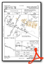
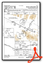
Instrument Approach Procedure (IAP) Charts
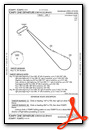
Departure Procedure Obstacles (DPO) Charts
Nearby Airports with Instrument Procedures
| ID | Name | Heading / Distance | ||
|---|---|---|---|---|
 |
PAOB | Kobuk Airport | 076° | 6.4 |
|
PAFM | Ambler Airport | 309° | 21.0 |
|
PASK | Selawik Airport | 256° | 69.4 |
|
PAHL | Huslia Airport | 164° | 74.3 |
|
PAHU | Hughes Airport | 124° | 86.5 |
Airport Images
Do you have a recent image of this airport? Upload it here!


