Login
Register


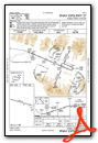
OBU
Kobuk Airport
Official FAA Data Effective 2026-02-19 0901Z
Chart Supplement

VFR Chart of PAOB
Sectional Charts at SkyVector.com
IFR Chart of PAOB
Enroute Charts at SkyVector.com
Location Information for PAOB
Coordinates: N66°54.74' / W156°53.84'Located 00 miles N of Kobuk, Alaska on 167 acres of land. View all Airports in Alaska.
Surveyed Elevation is 142 feet MSL.
Operations Data
|
|
Airport Communications
| CTAF: | 122.700 |
|---|---|
| AWOS-3P at SHG (6.4 W): | 118.525 907-560-7612 |
| AWOS-3P at AFM (25.4 NW): | 132.1 907-621-7610 |
- COMMUNICATIONS PRVDD BY KOTZEBUE FSS ON FREQ 122.0 (AMBLER RCO).
- APCH/DEP SVC PRVDD BY ANCHORAGE ARTCC (ZAN) ON FREQ 119.2/263.0 (KOTZEBUE RCAG).
Nearby Navigation Aids
|
| ||||||||||||||||||

Runway 09/27
PARL PWR LINE N. | ||
| Dimensions: | 4020 x 75 feet / 1225 x 23 meters | |
|---|---|---|
| Surface: | Gravel in Good Condition | |
| Edge Lighting: | Medium Intensity | |
| Runway 09 | Runway 27 | |
| Coordinates: | N66°54.83' / W156°54.65' | N66°54.65' / W156°53.03' |
| Elevation: | 140.0 | 137.8 |
| Traffic Pattern: | Left | Left |
| Runway Heading: | 106° True | 286° True |
| Obstacles: | 6 ft Brush 0 ft from runway, 126 ft right of center | 25 ft Brush 0 ft from runway, 126 ft right of center |
Ownership Information
| Ownership: | Publicly owned | |
|---|---|---|
| Owner: | ALASKA DOT&PF NORTHERN REGION | |
| 2301 PEGER ROAD | ||
| FAIRBANKS, AK 99709 | ||
| 907-451-2200 | ||
| Manager: | ALVIN WERNEKE | |
| BOX 55 | ||
| KOTZUBUE, AK 99752 | ||
| 907-442-3147 | ||
Other Remarks
- RWY COND UNMNT; RCMD VISUAL INSP BFR LNDG.
- FLOAT PLANE OPS ON LAKE.
- WX CAMERA AVBL ON INTERNET AT HTTPS://WEATHERCAMS.FAA.GOV
- COLD TEMPERATURE AIRPORT. ALTITUDE CORRECTION REQUIRED AT OR BELOW -37C.
- DIP ABEAM SLOUGH.
- ACTVT MIRL RWY 09/27 - CTAF.
Weather Minimums

Instrument Approach Procedure (IAP) Charts

Nearby Airports with Instrument Procedures
| ID | Name | Heading / Distance | ||
|---|---|---|---|---|
 |
PAGH | Shungnak Airport | 257° | 6.4 |
|
PAFM | Ambler Airport | 297° | 25.4 |
|
PAHL | Huslia Airport | 169° | 74.3 |
|
PAHU | Hughes Airport | 128° | 82.3 |
Airport Images
Do you have a recent image of this airport? Upload it here!


