Login
Register
ANP
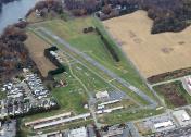
Lee Airport
Official FAA Data Effective 2026-01-22 0901Z
VFR Chart of KANP
Sectional Charts at SkyVector.com
IFR Chart of KANP
Enroute Charts at SkyVector.com
Location Information for KANP
Coordinates: N38°56.57' / W76°34.10'Located 05 miles SW of Annapolis, Maryland on 79 acres of land. View all Airports in Maryland.
Estimated Elevation is 34 feet MSL.
Operations Data
|
|
Airport Communications
| POTOMAC APPROACH: | 119.7 290.475 |
|---|---|
| POTOMAC DEPARTURE: | 119.7 290.475 |
| CTAF: | 122.900 |
| AWOS-3 at W29 (11.4 E): | 120.575 410-643-8795 |
| AWOS-3 at FME (12.3 NW): | 123.925 |
| ASOS at BWI (14.7 N): | 227-217-0474 |
Nearby Navigation Aids
|
| ||||||||||||||||||||||||||||||||||||||||||||||||||||||||||||
Runway 12/30
| Dimensions: | 2505 x 48 feet / 764 x 15 meters | |
|---|---|---|
| Surface: | Asphalt in Fair Condition MINOR PAVEMENT CRACKS FULL LENGTH. | |
| Edge Lighting: | Low Intensity | |
| Runway 12 | Runway 30 | |
| Coordinates: | N38°56.63' / W76°34.36' | N38°56.51' / W76°33.85' |
| Elevation: | 30.6 | 31.3 |
| Traffic Pattern: | Left | Left |
| Runway Heading: | 108° True | 288° True |
| Displaced Threshold: | 476 Feet | 326 Feet |
| Markings: | Basic in good condition. | Non-Precision Instrument in good condition. |
| Glide Slope Indicator | P2L (5.75° Glide Path Angle) VGSI APCHS TO BE FLOWN. RWY 12 VGSI RELIABLE ON CNTLRN ONLY. | P2R (4.25° Glide Path Angle) |
| Obstacles: | 72 ft Trees 284 ft from runway, 115 ft right of center RWY 12 APCH RATIO 20:1 TO DSPLCD THR & CNTRLN. 6 FT FENCE ACROSS APCH END MARKED. 10 FT ROAD 156 FT FM THLD. |
64 ft Trees 819 ft from runway, 86 ft right of center RWY 30 APCH RATIO 20:1 TO THE DSPLCD THR AND CNTRLN. +6 FT FENCE ACROSS APCH END MKD. +15 FT PUBLIC ROAD AT THLD, R OF CNTRLN. |
Services Available
| Fuel: | 100LL (blue) |
|---|---|
| Transient Storage: | Tiedowns |
| Airframe Repair: | MAJOR |
| Engine Repair: | MAJOR |
| Bottled Oxygen: | NOT AVAILABLE |
| Bulk Oxygen: | NOT AVAILABLE |
| Other Services: | PILOT INSTRUCTION,AIRCRAFT RENTAL |
Ownership Information
| Ownership: | Privately Owned | |
|---|---|---|
| Owner: | LEE AIRPORT AUTHORITY LLC | CORPORATION ESTABLISHED BY MARY C. LEE |
| P.O. BOX 2342 | ||
| ANNAPOLIS, MD 21401 | ||
| 410-956-1280 | ||
| Manager: | LEE RUNWAY MANAGER LLC | |
| P.O. BOX 2342 | ||
| ANNAPOLIS, MD 21401 | ||
| 410-956-1280 | ||
Other Remarks
- NO LANDING ON GRASS. LDG FEE AFTER ONE HOUR OR OVERNIGHT.
- TOUCH & GO OPNS PROHIBITED.
- NO TAKE-OFFS AFTER 2200 DAILY.
- NO GRASS CROSSOVER FM RWY 12/30 TO TWY ROLLOUT TO THE END OF RWY.
- HVY BIRD AND WILDLIFE ACT ON AND INVOF ARPT.
- ARPT CLSD 2200-0700 LCL, CTC ARPT MANAGER FOR DETAILS.
- FOR CD CTC POTOMAC APCH AT 866-429-5882.
- ACTVT LIRL RWY 12/30 - CTAF. LIGHTING INOP BTW 2200-0700.
- DUSK-2200.
Weather Minimums
Instrument Approach Procedure (IAP) Charts
Nearby Airports with Instrument Procedures
| ID | Name | Heading / Distance | ||
|---|---|---|---|---|
 |
W00 | Freeway Airport | 269° | 9.5 |
 |
W29 | Bay Bridge Airport | 079° | 11.3 |
 |
KFME | Fort Meade Exec Airport | 313° | 12.4 |
 |
KBWI | Baltimore/Washington International Thurgood Marshall Airport | 341° | 14.7 |
 |
KADW | Joint Base Andrews Airport | 240° | 16.1 |
 |
KCGS | College Park Airport | 277° | 16.7 |
 |
KVKX | Potomac Airfield Airport | 237° | 21.6 |
 |
KDCA | Ronald Reagan Washington Ntl Airport | 256° | 22.7 |
 |
KMTN | Martin State Airport | 017° | 24.1 |
 |
KESN | Easton/Newnam Field Airport | 109° | 24.8 |
 |
KGAI | Montgomery County Airpark Airport | 296° | 31.0 |
 |
2W5 | Maryland Airport | 228° | 31.5 |


