Login
Register
W00
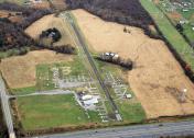
Freeway Airport
Official FAA Data Effective 2025-12-25 0901Z
VFR Chart of W00
Sectional Charts at SkyVector.com
IFR Chart of W00
Enroute Charts at SkyVector.com
Location Information for W00
Coordinates: N38°56.48' / W76°46.34'Located 02 miles NW of Bowie, Maryland on 100 acres of land. View all Airports in Maryland.
Surveyed Elevation is 168 feet MSL.
Operations Data
|
|
Airport Communications
| POTOMAC APPROACH: | 128.0 ;DC SFRA 335.5 |
|---|---|
| POTOMAC DEPARTURE: | 128.0 ;DC SFRA 335.5 |
| TIKEE STAR: | 120.45 306.925 |
| UNICOM: | 123.075 |
| CTAF: | 123.075 |
| IRONS STAR: | 126.4 282.375 |
| AWOS-3 at CGS (7.4 W): | 121.225 301-864-5497 |
| AWOS-3 at FME (8.6 N): | 123.925 |
| D-ATIS at ADW (9.0 SW): | 133.675 |
Nearby Navigation Aids
|
| ||||||||||||||||||||||||||||||||||||||||||||||||||||||||||||
Runway 18/36
| Dimensions: | 2420 x 40 feet / 738 x 12 meters | |
|---|---|---|
| Surface: | Asphalt in Fair Condition | |
| Edge Lighting: | Medium Intensity | |
| Runway 18 | Runway 36 | |
| Coordinates: | N38°56.68' / W76°46.39' | N38°56.29' / W76°46.30' |
| Elevation: | 168.1 | 151.6 |
| Traffic Pattern: | Left | Right |
| Runway Heading: | 170° True | 350° True |
| Displaced Threshold: | 230 Feet | |
| Markings: | Non-Precision Instrument in fair condition. | Non-Precision Instrument in fair condition. |
| Glide Slope Indicator | P2R (6.00° Glide Path Angle) | P2L (5.50° Glide Path Angle) |
| Obstacles: | 67 ft Trees 848 ft from runway, 164 ft left of center +7 FT ROAD AT 115 FT OUT, OB. |
48 ft Trees 569 ft from runway, 90 ft left of center APCH RATIO 15:1 TO DSPLCD THR AT CNTRLN. +18 FT TREES AT 175 FT OUT, 22 FT R. |
Services Available
| Fuel: | 100LL (blue) |
|---|---|
| Transient Storage: | Tiedowns |
| Airframe Repair: | MAJOR |
| Engine Repair: | MAJOR |
| Bottled Oxygen: | NONE |
| Bulk Oxygen: | NONE |
| Other Services: | CHARTER SERVICE,PILOT INSTRUCTION,AIRCRAFT RENTAL |
Ownership Information
| Ownership: | Privately Owned | |
|---|---|---|
| Owner: | FREEWAY AIRPORT INC. | |
| 3900 CHURCH RD | ||
| BOWIE, MD 20721 | ||
| 301-390-6424 | ||
| Manager: | MATTHEW LINDQUIST | |
| 3900 CHURCH RD | ||
| MITCHELLVILLE, MD 20716 | ||
| 301-390-6424 | ||
Other Remarks
- TPA 1000 FT MSL (832 FT AGL) FOR ACFT LESS THAN 4000 LBS MAX GWT; TPA 1200 FT MSL (1032 FT AGL) FOR ACFT GREATER THAN 4000 LBS.
- -15 FT DROP 80 FT FROM APCH TO RWY 36.
- -7 FT DROP 50 FT FM APCH END RWY 18.
- UNLGTD ANTENNA 135 FT AGL 600 FT NW AER 18.
- FOR CD CTC POTOMAC APCH AT 866-599-3874.
- TWY RUNUP AREA FOR RWY 36 CLSD.
- 0LL 100LL AVBL WHEN ATNDD.
- ACTVT PAPI RWYS 18 & 36; MIRL RWY 18/36 - CTAF.
Weather Minimums
Standard Terminal Arrival (STAR) Charts
Instrument Approach Procedure (IAP) Charts
Nearby Airports with Instrument Procedures
| ID | Name | Heading / Distance | ||
|---|---|---|---|---|
 |
KCGS | College Park Airport | 288° | 7.4 |
 |
KFME | Tipton Airport | 004° | 8.7 |
 |
KADW | Joint Base Andrews Airport | 209° | 9.0 |
 |
KANP | Lee Airport | 089° | 9.5 |
 |
KDCA | Ronald Reagan Washington Ntl Airport | 246° | 13.5 |
 |
KVKX | Potomac Airfield Airport | 216° | 14.4 |
 |
KBWI | Baltimore/Washington International Thurgood Marshall Airport | 018° | 14.9 |
 |
W29 | Bay Bridge Airport | 084° | 20.8 |
 |
KGAI | Montgomery County Airpark Airport | 306° | 22.9 |
 |
KDAA | Davison AAF Airport | 234° | 23.5 |
 |
2W5 | Maryland Airport | 214° | 25.0 |
 |
W50 | Davis Airport | 315° | 25.3 |


