Login
Register


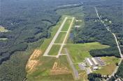
2W5
Maryland Airport
Official FAA Data Effective 2026-01-22 0901Z
Chart Supplement

VFR Chart of 2W5
Sectional Charts at SkyVector.com
IFR Chart of 2W5
Enroute Charts at SkyVector.com
Location Information for 2W5
Coordinates: N38°35.82' / W77°4.35'Located 04 miles E of Indian Head, Maryland on 314 acres of land. View all Airports in Maryland.
Estimated Elevation is 175 feet MSL.
Operations Data
|
|
Airport Communications
| POTOMAC APPROACH: | 118.95 ;DC SFRA 124.7 ;DC SFRA 257.2 338.2 ;DC-SFRA |
|---|---|
| POTOMAC DEPARTURE: | 118.95 ;DC SFRA 124.7 ;DC SFRA 257.2 338.2 ;DC-SFRA |
| TIKEE STAR: | 120.45 306.925 |
| IRONS STAR: | 126.4 282.375 |
| UNICOM: | 122.700 |
| CTAF: | 122.700 |
| ATIS at DAA (8.7 NW): | 128.175 |
| ATIS at NYG (12.3 SW): | 263.15 |
| D-ATIS at DCA (15.4 N): | 132.65 |
Nearby Navigation Aids
|
| ||||||||||||||||||||||||||||||||||||||||||||||||||||||||||||


Runway 02/20
| Dimensions: | 3740 x 75 feet / 1140 x 23 meters | |
|---|---|---|
| Surface: | Asphalt in Good Condition | |
| Edge Lighting: | Medium Intensity | |
| Runway 02 | Runway 20 | |
| Coordinates: | N38°35.52' / W77°4.38' | N38°36.13' / W77°4.32' |
| Elevation: | 156.1 | 175.0 |
| Traffic Pattern: | Left | Left |
| Runway Heading: | 5° True | 185° True |
| Markings: | Non-Precision Instrument in good condition. | Basic in good condition. |
| Glide Slope Indicator | P4L (3.00° Glide Path Angle) | |
| REIL: | Yes | |
| Obstacles: | 85 ft Trees 2236 ft from runway, 195 ft left of center | 67 ft Trees 1712 ft from runway, 240 ft left of center |
Services Available
| Fuel: | 100LL (blue), Jet-A |
|---|---|
| Transient Storage: | Tiedowns |
| Airframe Repair: | MINOR |
| Engine Repair: | MINOR |
| Bottled Oxygen: | NONE |
| Bulk Oxygen: | NONE |
| Other Services: | AVIONICS,PILOT INSTRUCTION AME AVBL BY APPOINTMENT. |
Ownership Information
| Ownership: | Privately Owned | |
|---|---|---|
| Owner: | PSM AVIATION LLC | |
| 3900 LIVINGSTON RD, | ||
| INDIAN HEAD, MD 20640 | ||
| 301-283-6202 | ||
| Manager: | SHEEL PATEL | |
| 3900 LIVINGSTON RD | ||
| INDIAN HEAD, MD 20640 | ||
| 301-283-6202 | ||
Other Remarks
- BIRDS & WILDLIFE ON & INVOF ARPT.
- FOR CD CTC POTOMAC APCH AT 866-599-3874.
- ACTVT REIL RWY 02; PAPI RWY 02; MIRL RWY 02/20 - CTAF. ARPT DEACTIVATES PAPI RWY 02 WHEN WINDS FAVOR RWY 20.
Weather Minimums
Standard Terminal Arrival (STAR) Charts
Instrument Approach Procedure (IAP) Charts

Nearby Airports with Instrument Procedures
| ID | Name | Heading / Distance | ||
|---|---|---|---|---|
 |
KDAA | Davison AAF Airport | 324° | 8.7 |
|
KVKX | Potomac Airfield Airport | 031° | 10.6 |
|
KNYG | Quantico Mcaf (Turner Field) Airport | 242° | 12.3 |
|
KDCA | Ronald Reagan Washington Ntl Airport | 006° | 15.3 |
|
KADW | Joint Base Andrews Airport | 036° | 16.0 |
|
KRMN | Stafford Regional Airport | 236° | 21.6 |
|
KHEF | Manassas Regional/Harry P Davis Field Airport | 289° | 22.1 |
|
KCGS | College Park Airport | 017° | 24.0 |
|
W00 | Freeway Airport | 034° | 25.0 |
|
KEZF | Shannon Airport | 222° | 26.6 |
|
KIAD | Washington Dulles International Airport | 319° | 27.8 |
|
2W6 | St Mary's County Regional Airport | 124° | 29.8 |