Login
Register
APT
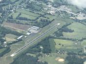
Marion County/Brown Field Airport
Official FAA Data Effective 2026-01-22 0901Z
VFR Chart of KAPT
Sectional Charts at SkyVector.com
IFR Chart of KAPT
Enroute Charts at SkyVector.com
Location Information for KAPT
Coordinates: N35°3.64' / W85°35.12'Located 04 miles SE of Jasper, Tennessee on 86 acres of land. View all Airports in Tennessee.
Surveyed Elevation is 641 feet MSL.
Operations Data
|
|
Airport Communications
| CHATTANOOGA APPROACH: | 119.2 323.075 |
|---|---|
| CHATTANOOGA DEPARTURE: | 119.2 323.075 |
| CTAF: | 122.800 |
| UNICOM: | 122.800 |
| ATIS at CHA (18.8 E): | 119.85 |
| ASOS at CHA (18.9 E): | 119.85 423-668-0530 |
| AWOS-3 at BGF (24.7 W): | 121.675 931-967-8445 |
- APCH/DEP SVC PRVDD BY ATLANTA ARTCC ON FREQS 132.05/354.025 (CHATTANOOGA RCAG) WHEN CHATTANOOGA APCH CTL CLSD.
Nearby Navigation Aids
|
| ||||||||||||||||||||||||||||||||||||||||||||||||
Runway 04/22
| Dimensions: | 3498 x 75 feet / 1066 x 23 meters | |
|---|---|---|
| Surface: | Asphalt in Excellent Condition | |
| Weight Limits: | S-30 | |
| Edge Lighting: | Medium Intensity | |
| Runway 04 | Runway 22 | |
| Coordinates: | N35°3.41' / W85°35.33' | N35°3.87' / W85°34.90' |
| Elevation: | 641.0 | 640.8 |
| Traffic Pattern: | Left | Right |
| Runway Heading: | 38° True | 218° True |
| Markings: | Non-Precision Instrument in good condition. | Non-Precision Instrument in good condition. |
| Glide Slope Indicator | P2L (3.50° Glide Path Angle) | P2L (3.50° Glide Path Angle) |
| REIL: | Yes | Yes |
| Obstacles: | 41 ft Tree 895 ft from runway, 188 ft left of center | |
Services Available
| Fuel: | 100LL (blue), Jet A+, Automotive Gasoline |
|---|---|
| Transient Storage: | Hangars,Tiedowns |
| Airframe Repair: | NOT AVAILABLE |
| Engine Repair: | NOT AVAILABLE |
| Bottled Oxygen: | NOT AVAILABLE |
| Bulk Oxygen: | NOT AVAILABLE |
| Other Services: | PARACHUTE JUMP ACTIVITY DSGND LNDG AREA IN GRASS AT CESSNA LN ONLY. |
Ownership Information
| Ownership: | Publicly owned | |
|---|---|---|
| Owner: | MARION COUNTY | |
| 31 COURTHOUSE SQUARE | ||
| JASPER, TN 37347 | ||
| 423-942-2552 | ||
| Manager: | WILLIAM NEAL | |
| 300 AIRPORT RD | ||
| JASPER, TN 37347 | ||
| 423-432-6627 | ||
Other Remarks
- ULTRALIGHT ACT & DEER ON & INVOF ARPT.
- FOR CD CTC CHATTANOOGA APCH AT 423-855-6478. WHEN APCH CLSD FOR CD CTC MEMPHIS ARTCC AT 901-368-8453/8449.
- GAS 87 OCTANE
- ACTVT REIL RWY 04 & 22; PAPI RWY 4 & 22; MIRL RWY 4/22 - CTAF.
Weather Minimums
Instrument Approach Procedure (IAP) Charts
Nearby Airports with Instrument Procedures
| ID | Name | Heading / Distance | ||
|---|---|---|---|---|
 |
KCHA | Lovell Field Airport | 094° | 18.9 |
 |
KBGF | Winchester Municipal Airport | 286° | 24.7 |
 |
9A5 | Barwick Lafayette Airport | 146° | 26.6 |
 |
4A6 | Scottsboro Municipal-Word Field Airport | 223° | 30.5 |
 |
4A9 | Isbell Field Airport | 190° | 35.8 |
 |
KTHA | Tullahoma Regional/Wm Northern Field Airport | 300° | 37.7 |
 |
KRZR | Cleveland Regional Jetport Airport | 076° | 39.7 |
 |
KRNC | Warren County Memorial Airport | 341° | 40.3 |
 |
KDNN | Dalton Municipal Airport | 119° | 40.7 |
 |
2A0 | Mark Anton Airport | 051° | 41.0 |
 |
KRMG | Richard B Russell Regional - J H Towers Field Airport | 153° | 47.4 |
 |
KFYM | Fayetteville Municipal Airport | 270° | 48.2 |


