Login
Register


RNC
Warren County Memorial Airport
Official FAA Data Effective 2026-01-22 0901Z
Chart Supplement

VFR Chart of KRNC
Sectional Charts at SkyVector.com
IFR Chart of KRNC
Enroute Charts at SkyVector.com
Location Information for KRNC
Coordinates: N35°41.92' / W85°50.63'Located 03 miles W of Mc Minnville, Tennessee on 353 acres of land. View all Airports in Tennessee.
Surveyed Elevation is 1031 feet MSL.
Operations Data
|
|
Airport Communications
| AWOS-3: | 135.525 Tel. 931-668-7056 |
|---|---|
| UNICOM: | 123.050 |
| CTAF: | 123.050 |
| AWOS-3P at SRB (26.0 NE): | 128.25 931-738-3111 |
| AWOS-3 at THA (27.3 SW): | 128.325 931-454-2052 |
| AWOS-3 at MBT (28.2 NW): | 133.975 615-849-2622 |
- APCH/DEP SVC PRVDD BY MEMPHIS ARTCC ON FREQS 128.15/323.125 (SHELBYVILLE RCAG).
Nearby Navigation Aids
|
| ||||||||||||||||||||||||||||||||||||||||||||||||||||||


Runway 05/23
| Dimensions: | 5000 x 100 feet / 1524 x 30 meters | |
|---|---|---|
| Surface: | Asphalt in Good Condition | |
| Weight Limits: | 39 /F/C/X/T, S-100, D-139 | |
| Edge Lighting: | Medium Intensity | |
| Runway 05 | Runway 23 | |
| Coordinates: | N35°41.66' / W85°51.02' | N35°42.18' / W85°50.24' |
| Elevation: | 1031.9 | 1027.1 |
| Traffic Pattern: | Left | Left |
| Runway Heading: | 51° True | 231° True |
| Markings: | Non-Precision Instrument in good condition. | Non-Precision Instrument in good condition. |
| Glide Slope Indicator | P4L (4.00° Glide Path Angle) PAPI UNUSBL BYD 7 DEGS LEFT OF CNTRLN. | P4L (3.00° Glide Path Angle) |
| REIL: | Yes | Yes |
| Obstacles: | 107 ft Trees 1797 ft from runway, 349 ft right of center | OBSTN CLNC SLOPE 40:1 AT DTHR. |
Services Available
| Fuel: | 100LL (blue), Jet A+ |
|---|---|
| Transient Storage: | Hangars,Tiedowns |
| Airframe Repair: | MAJOR |
| Engine Repair: | MAJOR |
| Bottled Oxygen: | NOT AVAILABLE |
| Bulk Oxygen: | NOT AVAILABLE |
Ownership Information
| Ownership: | Publicly owned | |
|---|---|---|
| Owner: | WARREN COUNTY | |
| WARREN COUNTY COURTHOUSE, 201 LOCUST STREET | ||
| MCMINNVILLE, TN 37110 | ||
| 931-473-2505 | ||
| Manager: | JIM DYER | |
| 48 WEST AIRPORT ROAD | ||
| MC MINNVILLE, TN 37110 | ||
| 931-668-7050 | ||
Other Remarks
- FOR CD CTC MEMPHIS ARTCC AT 901-368-8453/8449.
- ACTVT REIL RWY 05 & 23; PAPI RWY 05 & 23; MIRL RWY 05/23 - CTAF. MIRL RWY 05/23 PRESET LOW INTST; INCR INTST - CTAF.
Weather Minimums


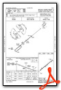
Instrument Approach Procedure (IAP) Charts

Nearby Airports with Instrument Procedures
| ID | Name | Heading / Distance | ||
|---|---|---|---|---|
 |
0A3 | Smithville Municipal Airport | 005° | 17.3 |
|
KSRB | Upper Cumberland Regional Airport | 035° | 26.3 |
|
KTHA | Tullahoma Regional/Wm Northern Field Airport | 226° | 27.5 |
|
KMBT | Murfreesboro Municipal Airport | 292° | 28.2 |
|
KSYI | Bomar Field/Shelbyville Municipal Airport | 254° | 30.4 |
|
KBGF | Winchester Municipal Airport | 199° | 33.1 |
|
M54 | Lebanon Municipal Airport | 322° | 37.4 |
|
KMQY | Smyrna Airport | 299° | 37.9 |
|
KCSV | Crossville Memorial-Whitson Field Airport | 067° | 40.0 |
|
KAPT | Marion County/Brown Field Airport | 161° | 40.3 |
|
2A0 | Mark Anton Airport | 105° | 46.4 |
|
KBNA | Nashville International Airport | 302° | 48.0 |


