Login
Register


4A6
Scottsboro Municipal-Word Field Airport
Official FAA Data Effective 2025-12-25 0901Z
Chart Supplement

VFR Chart of 4A6
Sectional Charts at SkyVector.com
IFR Chart of 4A6
Enroute Charts at SkyVector.com
Location Information for 4A6
Coordinates: N34°41.32' / W86°0.36'Located 02 miles NE of Scottsboro, Alabama on 49 acres of land. View all Airports in Alabama.
Surveyed Elevation is 650 feet MSL.
Operations Data
|
|
Airport Communications
| AWOS-3PT: | 120.125 Tel. 256-259-1148 |
|---|---|
| UNICOM: | 123.000 |
| CTAF: | 123.000 |
| AWOS-3PT at 4A9 (19.1 SE): | 119.025 256-845-5397 |
| AWOS-3PT at 8A1 (21.7 SW): | 121.125 |
| AWOS-3PT at MDQ (29.1 W): | 120.000 256-829-1242 |
- APCH/DEP SVC PRVDD BY ATLANTA ARTCC ON FREQS 124.5/270.325 (GADSDEN RCAG).
Nearby Navigation Aids
|
| ||||||||||||||||||||||||||||||||||||||||||


Runway 04/22
| Dimensions: | 5240 x 80 feet / 1597 x 24 meters | |
|---|---|---|
| Surface: | Asphalt in Good Condition | |
| Weight Limits: | S-15 | |
| Edge Lighting: | Medium Intensity | |
| Runway 04 | Runway 22 | |
| Coordinates: | N34°40.98' / W86°0.67' | N34°41.67' / W86°0.04' |
| Elevation: | 650.5 | 630.4 |
| Traffic Pattern: | Right | Left |
| Runway Heading: | 37° True | 217° True |
| Displaced Threshold: | 230 Feet RWY 22 LGTD THRS DSPLCD FOR NGT OPNS. |
|
| Markings: | Non-Precision Instrument in good condition. | Non-Precision Instrument in good condition. |
| Glide Slope Indicator | P4L (3.00° Glide Path Angle) OTS INDEFLY. | P4L (3.00° Glide Path Angle) |
| REIL: | Yes | Yes |
| Obstacles: | 55 ft Tree 1163 ft from runway, 211 ft right of center | 31 ft Tree 503 ft from runway, 248 ft right of center APCH SLOPE 20:1 FM DSPLCD THR. |
Services Available
| Fuel: | 100LL (blue), Jet-A |
|---|---|
| Transient Storage: | Tiedowns |
| Airframe Repair: | MAJOR |
| Engine Repair: | MAJOR REPAIRS AVBL ON CALL 256-259-3702. |
| Bottled Oxygen: | NONE |
| Bulk Oxygen: | NONE |
| Other Services: | PILOT INSTRUCTION |
Ownership Information
| Ownership: | Publicly owned | |
|---|---|---|
| Owner: | CITY OF SCOTTSBORO | |
| 316 BROAD ST | ||
| SCOTTSBORO, AL 35768 | ||
| 256-574-3100 | ||
| Manager: | COREY PORTER | |
| 86 AVIATION CIRCLE | ||
| SCOTTSBORO, AL 35768 | ||
| 256-259-3702 | ||
Other Remarks
- RED LGTD TV TWR 1 MILE SW.
- TWY LGTS FOR TWY TURNOFF ONLY.
- FOR CD CTC ATLANTA ARTCC AT 770-210-7692.
- FOR SVC AFT HRS CALL 256-603-5723.
- MIRL RWY 04/22 PRESET LOW INTST; TO INCR INTST ACTVT- CTAF. TO ACTVT REIL RWY 04 & 22 - CTAF. PAPI RWY 04 & 22 OPR CONSLY.
Weather Minimums
Instrument Approach Procedure (IAP) Charts

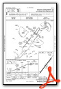
Nearby Airports with Instrument Procedures
| ID | Name | Heading / Distance | ||
|---|---|---|---|---|
 |
4A9 | Isbell Field Airport | 132° | 19.1 |
|
8A1 | Guntersville Municipal/Joe Starnes Field Airport | 216° | 21.1 |
|
KMDQ | Huntsville Exec Tom Sharp Jr Field Airport | 290° | 29.1 |
|
KBGF | Winchester Municipal Airport | 354° | 29.4 |
|
KBFZ | Albertville Regional/Thomas J Brumlik Field Airport | 204° | 30.2 |
|
KAPT | Marion County/Brown Field Airport | 042° | 30.5 |
|
9A5 | Barwick Lafayette Airport | 089° | 35.4 |
|
KFYM | Fayetteville Municipal Airport | 309° | 35.4 |
|
KHSV | Huntsville International-Carl T Jones Field Airport | 265° | 38.2 |
|
KPYP | Centre Piedmont/Cherokee County Regional Airport | 151° | 40.9 |
|
KTHA | Tullahoma Regional/Wm Northern Field Airport | 344° | 43.1 |
|
KGAD | Northeast Alabama Regional Airport | 185° | 43.2 |
Airport Images

By: GCA7SKY

By: GCA7SKY


